Property Information
mobile view
| Serial Number: 66:696:0023 |
Serial Life: 2020... |
|
|
 Total Photos: 2
|
| |
|
|
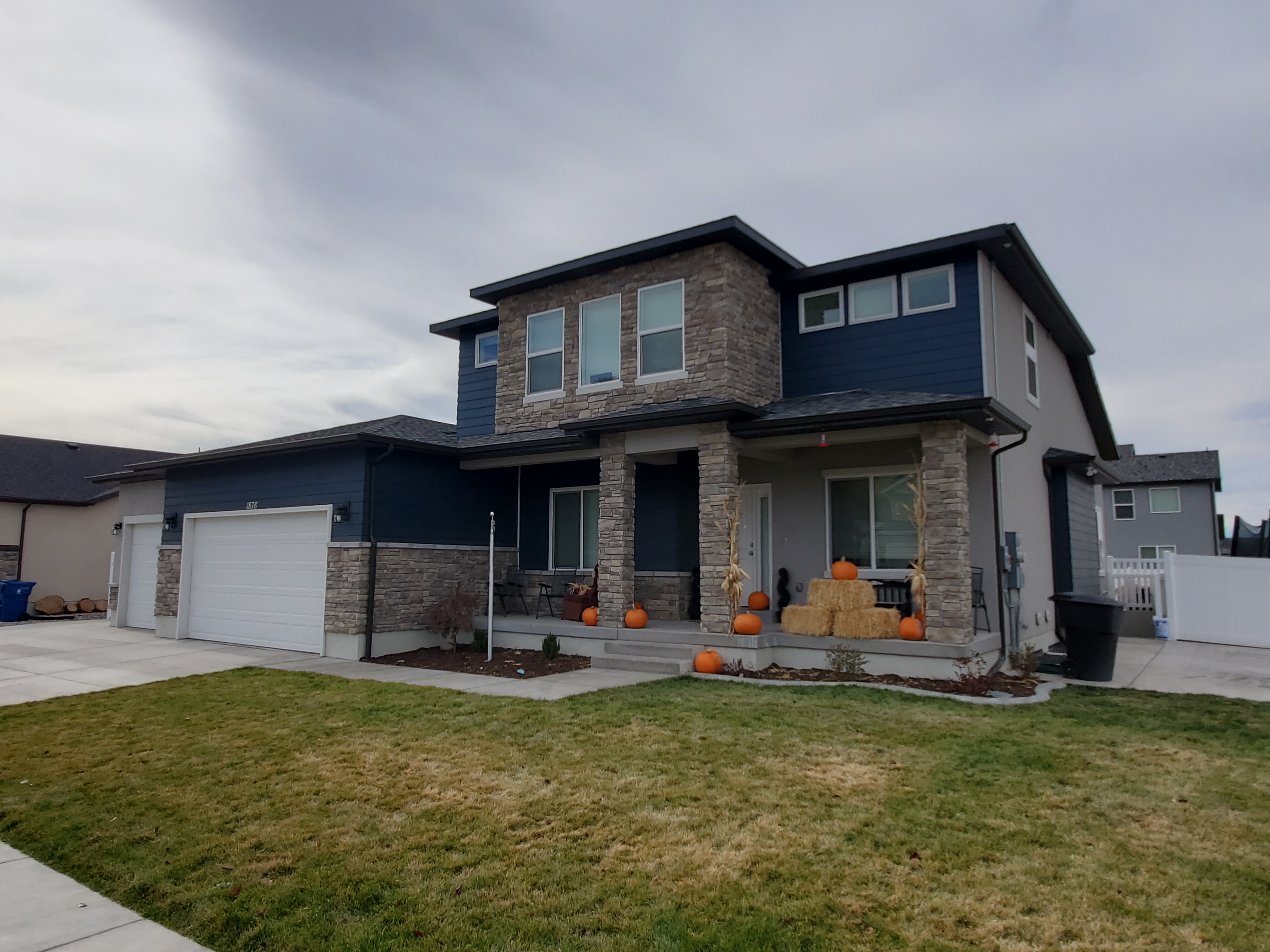
| Property Address: 1876 S 550 WEST - PAYSON
more see "Addrs" tab below..
|
|
| Mailing Address: 1876 S 550 W PAYSON, UT 84651-8736 |
|
| Acreage: 0.266177 |
|
| Last Document:
39781-2020
|
|
| Subdivision Map Filing |
|
| Taxing Description:
LOT 23, PLAT H, SPRINGSIDE MEADOWS SUB AREA 0.266 AC.
*Taxing description NOT FOR LEGAL DOCUMENTS
|
|
- Owner Names
- Value History
- Tax History
- Location
- Photos
- Documents
- Aerial Image
- Addrs
| |
----- Real Estate Values ----- |
---Improvements--- |
---Greenbelt--- |
Total |
| Year |
Com |
Res |
Agr |
Tot |
Com |
Res |
Agr |
Tot |
Land |
Homesite |
Tot |
Market Value |
| 2024 |
$0 |
$156,500 |
$0 |
$156,500 |
$0 |
$496,500 |
$0 |
$496,500 |
$0 |
$0 |
$0 |
$653,000 |
| 2023 |
$0 |
$156,500 |
$0 |
$156,500 |
$0 |
$518,900 |
$0 |
$518,900 |
$0 |
$0 |
$0 |
$675,400 |
| 2022 |
$0 |
$166,900 |
$0 |
$166,900 |
$0 |
$433,500 |
$0 |
$433,500 |
$0 |
$0 |
$0 |
$600,400 |
| 2021 |
$0 |
$119,200 |
$0 |
$119,200 |
$0 |
$355,800 |
$0 |
$355,800 |
$0 |
$0 |
$0 |
$475,000 |
| 2020 |
$0 |
$108,400 |
$0 |
$108,400 |
$0 |
$0 |
$0 |
$0 |
$0 |
$0 |
$0 |
$108,400 |
| Year |
General Taxes |
Adjustments |
Net Taxes |
Fees |
Payments |
Tax Balance* |
Balance Due |
Tax District |
| 2025 |
$0.00 |
$0.00 |
$0.00 |
$0.00 |
|
$0.00
|
$0.00 |
170 - PAYSON CITY |
| 2024 |
$3,529.01 |
$0.00 |
$3,529.01 |
$0.00 |
|
$0.00
|
$0.00 |
170 - PAYSON CITY |
| 2023 |
$3,640.03 |
$0.00 |
$3,640.03 |
$0.00 |
|
$0.00
|
$0.00 |
170 - PAYSON CITY |
| 2022 |
$3,289.98 |
$0.00 |
$3,289.98 |
$0.00 |
|
$0.00
|
$0.00 |
170 - PAYSON CITY |
| 2021 |
$2,950.56 |
$0.00 |
$2,950.56 |
$0.00 |
|
$0.00
|
$0.00 |
170 - PAYSON CITY |
| 2020 |
$1,251.37 |
$0.00 |
$1,251.37 |
$0.00 |
|
$0.00
|
$0.00 |
170 - PAYSON CITY |
* Note: Original tax amount (Does not include applicable interest and/or fees).
| Entry # |
Date |
Recorded |
Type |
Party1 (Grantor) |
Party2 (Grantee) |
| 49036-2021 |
02/02/2021 |
03/15/2021 |
REC |
CENTRAL BANK TEE |
RIDING SIDING CONSTRUCTION LLC |
| 39783-2020 |
03/27/2020 |
03/27/2020 |
WD |
ADAMS, ERIC GOLDEN |
ADAMS, ERIC GOLDEN & CASSANDRA LYNN |
| 39782-2020 |
03/27/2020 |
03/27/2020 |
D TR |
ADAMS, ERIC GOLDEN |
SECURITYNATIONAL MORTGAGE COMPANY |
| 39781-2020 |
03/27/2020 |
03/27/2020 |
WD |
RIDING SIDING CONSTRUCTION LLC |
ADAMS, ERIC GOLDEN |
| 8722-2020 |
01/21/2020 |
01/23/2020 |
REC |
COTTONWOOD TITLE INSURANCE AGENCY INC TEE |
RIDING SIDING CONSTRUCTION LLC |
| 1580-2020 |
12/20/2019 |
01/06/2020 |
P REC |
COTTONWOOD TITLE INSURANCE AGENCY INC TEE |
RIDING SIDING CONSTRUCTION LLC |
| 1504-2020 |
01/06/2020 |
01/06/2020 |
REC |
COTTONWOOD TITLE INSURANCE AGENCY INC TEE |
SALISBURY LAND DEVELOPMENT LLC |
| 134454-2019 |
12/16/2019 |
12/18/2019 |
REC |
COTTONWOOD TITLE INSURANCE AGENCY INC TEE |
RIDING SIDING CONSTRUCTION LLC |
| 125210-2019 |
11/25/2019 |
11/26/2019 |
D TR |
RIDING SIDING CONSTRUCTION LLC |
CENTRAL BANK |
| 108798-2019 |
10/04/2019 |
10/22/2019 |
REC |
COTTONWOOD TITLE INSURANCE AGENCY INC TEE |
RIDING SIDING CONSTRUCTION LLC |
| 95699-2019 |
09/24/2019 |
09/25/2019 |
D TR |
RIDING SIDING CONSTRUCTION LLC |
SECURITY NATIONAL LIFE INSURANCE COMPANY |
| 90470-2019 |
02/20/2019 |
09/13/2019 |
S PLAT |
RIDING SIDING CONSTRUCTION LLC |
SPRINGSIDE MEADOWS PLAT H |
1876 S 550 WEST - PAYSON
569 W 1870 SOUTH - PAYSON
Main Menu Comments or Concerns on Value/Appraisal - Assessor's Office
Documents/Owner/Parcel information - Recorder's Office
Address Change for Tax Notice
This page was created on 2/16/2025 5:50:12 PM |
