Property Information
mobile view
| Serial Number: 08:076:0007 |
Serial Life: 1981... |
|
|
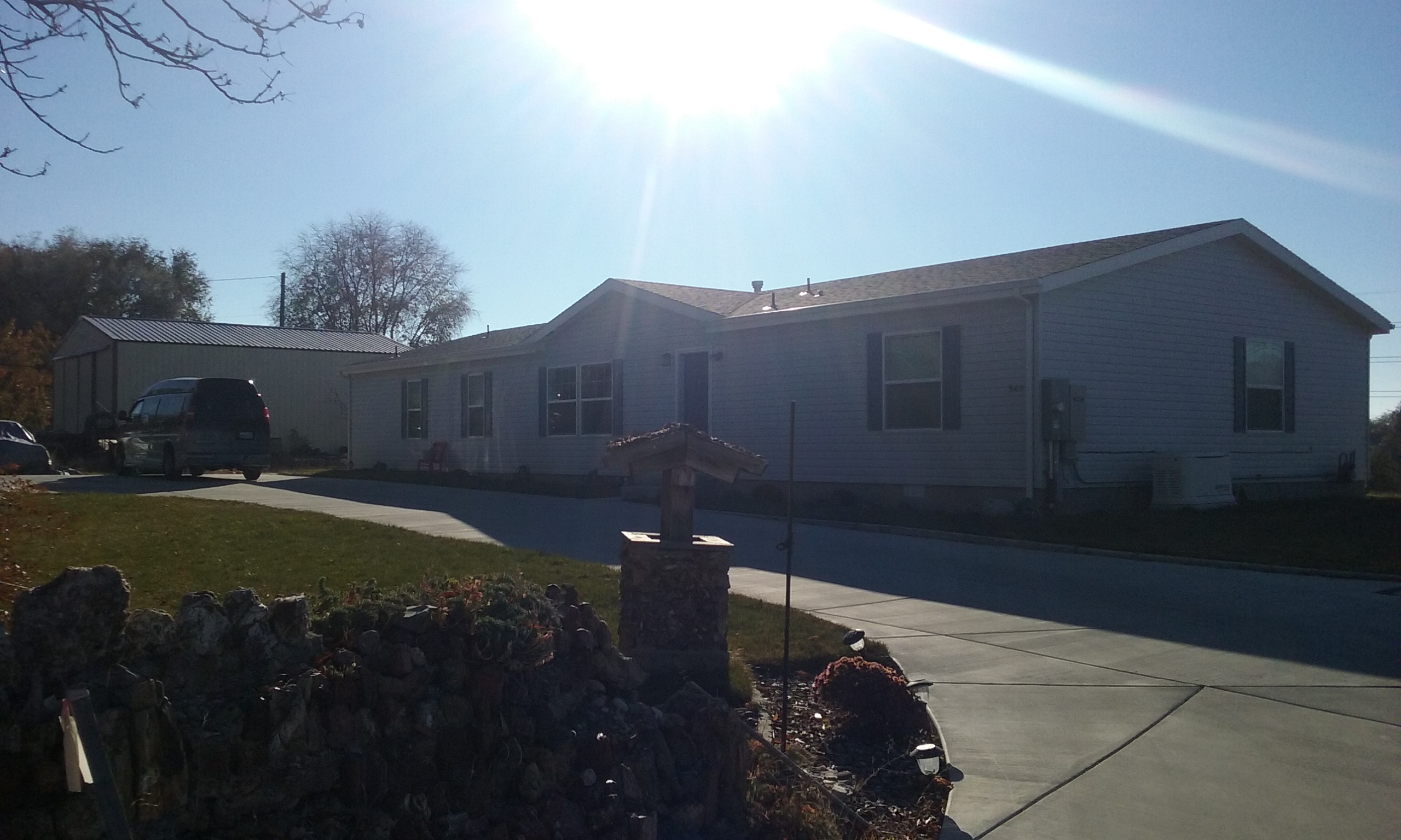 Total Photos: 5
|
| |
|
|
| Property Address: 540 E 100 SOUTH - PAYSON |
|
| Mailing Address: 540 E 100 S PAYSON, UT 84651-2303 |
|
| Acreage: 0.44 |
|
| Last Document:
72497-2017
|
|
| Subdivision Map Filing |
|
| Taxing Description:
COM E 85 FT FR SW COR LOT 3, BLK 7, PLAT K, PAYSON; N 198 FT; E 96 FT; S 198 FT; W 96 FT TO BEG. AREA .44 ACRES.
*Taxing description NOT FOR LEGAL DOCUMENTS
|
|
- Owner Names
- Value History
- Tax History
- Location
- Photos
- Documents
- Aerial Image
| 2018... |
|
BLACK, JEFF |
|
| 2018... |
|
BLACK, LISA |
|
| 2018... |
|
MANWILL, LOUISE |
|
| 2018NV |
|
BLACK, JEFF |
|
| 2018NV |
|
BLACK, JERRY E |
|
| 2018NV |
|
EWELL, PEGGY |
|
| 2018NV |
|
MANWILL, LOUISE |
|
| 2017 |
|
BLACK, DALE H |
|
| 2017 |
|
BLACK, JEFF |
|
| 2017 |
|
BLACK, JERRY E |
|
| 2017 |
|
EWELL, PEGGY |
|
| 2017 |
|
MANWILL, LOUISE |
|
| 2017NV |
|
BLACK, DALE |
|
| 2017NV |
|
BLACK, HAROLD |
|
| 2017NV |
|
FRANKS, BONNIE |
|
| 2017NV |
|
JOHNSON, MARIE |
|
| 2017NV |
|
LUCAS, FERN |
|
| 2017NV |
|
MANWILL, LOUISE |
|
| 1984-2016 |
|
BLACK, DALE |
|
| 1984-2016 |
|
MANWILL, LOUISE |
|
| 1983 |
|
BLACK, DALE |
|
| 1983 |
|
MANWILL, LOUISE |
|
| 1981-1982 |
|
BLACK, DALE |
|
| 1981-1982 |
|
MANWILL, LOUISE |
|
| |
----- Real Estate Values ----- |
---Improvements--- |
---Greenbelt--- |
Total |
| Year |
Com |
Res |
Agr |
Tot |
Com |
Res |
Agr |
Tot |
Land |
Homesite |
Tot |
Market Value |
| 2024 |
$0 |
$109,500 |
$0 |
$109,500 |
$0 |
$313,000 |
$0 |
$313,000 |
$0 |
$0 |
$0 |
$422,500 |
| 2023 |
$0 |
$109,500 |
$0 |
$109,500 |
$0 |
$260,400 |
$0 |
$260,400 |
$0 |
$0 |
$0 |
$369,900 |
| 2022 |
$0 |
$116,800 |
$0 |
$116,800 |
$0 |
$260,400 |
$0 |
$260,400 |
$0 |
$0 |
$0 |
$377,200 |
| 2021 |
$0 |
$93,400 |
$0 |
$93,400 |
$0 |
$260,400 |
$0 |
$260,400 |
$0 |
$0 |
$0 |
$353,800 |
| 2020 |
$0 |
$84,900 |
$0 |
$84,900 |
$0 |
$218,800 |
$0 |
$218,800 |
$0 |
$0 |
$0 |
$303,700 |
| 2019 |
$0 |
$79,300 |
$0 |
$79,300 |
$0 |
$204,500 |
$0 |
$204,500 |
$0 |
$0 |
$0 |
$283,800 |
| 2018 |
$0 |
$66,800 |
$0 |
$66,800 |
$0 |
$150,600 |
$0 |
$150,600 |
$0 |
$0 |
$0 |
$217,400 |
| 2017 |
$0 |
$64,300 |
$0 |
$64,300 |
$0 |
$149,100 |
$0 |
$149,100 |
$0 |
$0 |
$0 |
$213,400 |
| 2016 |
$0 |
$50,100 |
$0 |
$50,100 |
$0 |
$142,000 |
$0 |
$142,000 |
$0 |
$0 |
$0 |
$192,100 |
| 2015 |
$0 |
$50,100 |
$0 |
$50,100 |
$0 |
$8,800 |
$0 |
$8,800 |
$0 |
$0 |
$0 |
$58,900 |
| 2014 |
$0 |
$50,100 |
$0 |
$50,100 |
$0 |
$9,000 |
$0 |
$9,000 |
$0 |
$0 |
$0 |
$59,100 |
| 2013 |
$0 |
$43,000 |
$0 |
$43,000 |
$0 |
$65,900 |
$0 |
$65,900 |
$0 |
$0 |
$0 |
$108,900 |
| 2012 |
$0 |
$42,100 |
$0 |
$42,100 |
$0 |
$75,100 |
$0 |
$75,100 |
$0 |
$0 |
$0 |
$117,200 |
| 2011 |
$0 |
$42,600 |
$0 |
$42,600 |
$0 |
$78,900 |
$0 |
$78,900 |
$0 |
$0 |
$0 |
$121,500 |
| 2010 |
$0 |
$46,814 |
$0 |
$46,814 |
$0 |
$82,335 |
$0 |
$82,335 |
$0 |
$0 |
$0 |
$129,149 |
| 2009 |
$0 |
$63,100 |
$0 |
$63,100 |
$0 |
$74,300 |
$0 |
$74,300 |
$0 |
$0 |
$0 |
$137,400 |
| 2008 |
$0 |
$63,100 |
$0 |
$63,100 |
$0 |
$81,800 |
$0 |
$81,800 |
$0 |
$0 |
$0 |
$144,900 |
| 2007 |
$0 |
$65,000 |
$0 |
$65,000 |
$0 |
$84,300 |
$0 |
$84,300 |
$0 |
$0 |
$0 |
$149,300 |
| 2006 |
$0 |
$40,100 |
$0 |
$40,100 |
$0 |
$35,600 |
$0 |
$35,600 |
$0 |
$0 |
$0 |
$75,700 |
| 2005 |
$0 |
$38,164 |
$0 |
$38,164 |
$0 |
$33,860 |
$0 |
$33,860 |
$0 |
$0 |
$0 |
$72,024 |
| 2004 |
$0 |
$38,164 |
$0 |
$38,164 |
$0 |
$33,860 |
$0 |
$33,860 |
$0 |
$0 |
$0 |
$72,024 |
| 2003 |
$0 |
$38,164 |
$0 |
$38,164 |
$0 |
$33,860 |
$0 |
$33,860 |
$0 |
$0 |
$0 |
$72,024 |
| 2002 |
$0 |
$38,164 |
$0 |
$38,164 |
$0 |
$33,860 |
$0 |
$33,860 |
$0 |
$0 |
$0 |
$72,024 |
| 2001 |
$0 |
$43,867 |
$0 |
$43,867 |
$0 |
$30,782 |
$0 |
$30,782 |
$0 |
$0 |
$0 |
$74,649 |
| 2000 |
$0 |
$40,997 |
$0 |
$40,997 |
$0 |
$26,786 |
$0 |
$26,786 |
$0 |
$0 |
$0 |
$67,783 |
| 1999 |
$0 |
$40,997 |
$0 |
$40,997 |
$0 |
$26,786 |
$0 |
$26,786 |
$0 |
$0 |
$0 |
$67,783 |
| 1998 |
$0 |
$40,997 |
$0 |
$40,997 |
$0 |
$26,786 |
$0 |
$26,786 |
$0 |
$0 |
$0 |
$67,783 |
| 1997 |
$0 |
$40,997 |
$0 |
$40,997 |
$0 |
$26,786 |
$0 |
$26,786 |
$0 |
$0 |
$0 |
$67,783 |
| 1996 |
$0 |
$31,815 |
$0 |
$31,815 |
$0 |
$20,787 |
$0 |
$20,787 |
$0 |
$0 |
$0 |
$52,602 |
| 1995 |
$0 |
$28,923 |
$0 |
$28,923 |
$0 |
$20,787 |
$0 |
$20,787 |
$0 |
$0 |
$0 |
$49,710 |
| 1994 |
$0 |
$16,914 |
$0 |
$16,914 |
$0 |
$16,764 |
$0 |
$16,764 |
$0 |
$0 |
$0 |
$33,678 |
| 1993 |
$0 |
$16,914 |
$0 |
$16,914 |
$0 |
$16,764 |
$0 |
$16,764 |
$0 |
$0 |
$0 |
$33,678 |
| 1992 |
$0 |
$15,517 |
$0 |
$15,517 |
$0 |
$15,380 |
$0 |
$15,380 |
$0 |
$0 |
$0 |
$30,897 |
| 1991 |
$0 |
$13,611 |
$0 |
$13,611 |
$0 |
$13,491 |
$0 |
$13,491 |
$0 |
$0 |
$0 |
$27,102 |
| 1990 |
$0 |
$13,611 |
$0 |
$13,611 |
$0 |
$13,491 |
$0 |
$13,491 |
$0 |
$0 |
$0 |
$27,102 |
| 1989 |
$0 |
$13,611 |
$0 |
$13,611 |
$0 |
$13,491 |
$0 |
$13,491 |
$0 |
$0 |
$0 |
$27,102 |
| 1988 |
$0 |
$13,612 |
$0 |
$13,612 |
$0 |
$13,492 |
$0 |
$13,492 |
$0 |
$0 |
$0 |
$27,104 |
| 1987 |
$0 |
$14,033 |
$0 |
$14,033 |
$0 |
$13,908 |
$0 |
$13,908 |
$0 |
$0 |
$0 |
$27,941 |
| 1986 |
$0 |
$14,034 |
$0 |
$14,034 |
$0 |
$13,909 |
$0 |
$13,909 |
$0 |
$0 |
$0 |
$27,943 |
| 1985 |
$0 |
$14,033 |
$0 |
$14,033 |
$0 |
$13,908 |
$0 |
$13,908 |
$0 |
$0 |
$0 |
$27,941 |
| 1984 |
$0 |
$14,175 |
$0 |
$14,175 |
$0 |
$14,050 |
$0 |
$14,050 |
$0 |
$0 |
$0 |
$28,225 |
| Year |
General Taxes |
Adjustments |
Net Taxes |
Fees |
Payments |
Tax Balance* |
Balance Due |
Tax District |
| 2025 |
$0.00 |
$0.00 |
$0.00 |
$0.00 |
|
$0.00
|
$0.00 |
170 - PAYSON CITY |
| 2024 |
$2,283.32 |
$0.00 |
$2,283.32 |
$0.00 |
|
$0.00
|
$0.00 |
170 - PAYSON CITY |
| 2023 |
$1,993.56 |
$0.00 |
$1,993.56 |
$0.00 |
|
$0.00
|
$0.00 |
170 - PAYSON CITY |
| 2022 |
$2,066.92 |
$0.00 |
$2,066.92 |
$0.00 |
|
$0.00
|
$0.00 |
170 - PAYSON CITY |
| 2021 |
$2,197.70 |
$0.00 |
$2,197.70 |
$0.00 |
|
$0.00
|
$0.00 |
170 - PAYSON CITY |
| 2020 |
$1,928.25 |
$0.00 |
$1,928.25 |
$0.00 |
|
$0.00
|
$0.00 |
170 - PAYSON CITY |
| 2019 |
$1,757.57 |
$0.00 |
$1,757.57 |
$0.00 |
|
$0.00
|
$0.00 |
170 - PAYSON CITY |
| 2018 |
$1,396.94 |
$0.00 |
$1,396.94 |
$0.00 |
|
$0.00
|
$0.00 |
170 - PAYSON CITY |
| 2017 |
$1,402.22 |
$0.00 |
$1,402.22 |
$0.00 |
|
$0.00
|
$0.00 |
170 - PAYSON CITY |
| 2016 |
$1,270.61 |
$0.00 |
$1,270.61 |
$0.00 |
|
$0.00
|
$0.00 |
170 - PAYSON CITY |
| 2015 |
$713.22 |
$0.00 |
$713.22 |
$0.00 |
|
$0.00
|
$0.00 |
170 - PAYSON CITY |
| 2014 |
$710.50 |
$0.00 |
$710.50 |
$0.00 |
|
$0.00
|
$0.00 |
170 - PAYSON CITY |
| 2013 |
$753.72 |
$0.00 |
$753.72 |
$0.00 |
|
$0.00
|
$0.00 |
170 - PAYSON CITY |
| 2012 |
$823.41 |
$0.00 |
$823.41 |
$0.00 |
|
$0.00
|
$0.00 |
170 - PAYSON CITY |
| 2011 |
$833.37 |
$0.00 |
$833.37 |
$0.00 |
|
$0.00
|
$0.00 |
170 - PAYSON CITY |
| 2010 |
$863.75 |
$0.00 |
$863.75 |
$0.00 |
|
$0.00
|
$0.00 |
170 - PAYSON CITY |
| 2009 |
$870.34 |
$0.00 |
$870.34 |
$0.00 |
|
$0.00
|
$0.00 |
170 - PAYSON CITY |
| 2008 |
$853.77 |
$0.00 |
$853.77 |
$0.00 |
|
$0.00
|
$0.00 |
170 - PAYSON CITY |
| 2007 |
$872.55 |
$0.00 |
$872.55 |
$0.00 |
|
$0.00
|
$0.00 |
170 - PAYSON CITY |
| 2006 |
$491.58 |
$0.00 |
$491.58 |
$0.00 |
|
$0.00
|
$0.00 |
170 - PAYSON CITY |
| 2005 |
$497.90 |
$0.00 |
$497.90 |
$0.00 |
|
$0.00
|
$0.00 |
170 - PAYSON CITY |
| 2004 |
$499.28 |
$0.00 |
$499.28 |
$0.00 |
|
$0.00
|
$0.00 |
170 - PAYSON CITY |
| 2003 |
$453.17 |
$0.00 |
$453.17 |
$0.00 |
|
$0.00
|
$0.00 |
170 - PAYSON CITY |
| 2002 |
$442.32 |
$0.00 |
$442.32 |
$0.00 |
|
$0.00
|
$0.00 |
170 - PAYSON CITY |
| 2001 |
$466.94 |
$0.00 |
$466.94 |
$0.00 |
|
$0.00
|
$0.00 |
170 - PAYSON CITY |
| 2000 |
$419.44 |
$0.00 |
$419.44 |
$0.00 |
|
$0.00
|
$0.00 |
170 - PAYSON CITY |
| 1999 |
$398.19 |
$0.00 |
$398.19 |
$0.00 |
|
$0.00
|
$0.00 |
170 - PAYSON CITY |
| 1998 |
$388.35 |
$0.00 |
$388.35 |
$0.00 |
|
$0.00
|
$0.00 |
170 - PAYSON CITY |
| 1997 |
$428.35 |
$0.00 |
$428.35 |
$0.00 |
|
$0.00
|
$0.00 |
170 - PAYSON CITY |
| 1996 |
$327.47 |
$0.00 |
$327.47 |
$0.00 |
|
$0.00
|
$0.00 |
170 - PAYSON CITY |
| 1995 |
$309.31 |
$0.00 |
$309.31 |
$0.00 |
|
$0.00
|
$0.00 |
170 - PAYSON CITY |
| 1994 |
$322.28 |
$0.00 |
$322.28 |
$0.00 |
|
$0.00
|
$0.00 |
170 - PAYSON CITY |
| 1993 |
$292.69 |
$0.00 |
$292.69 |
$0.00 |
|
$0.00
|
$0.00 |
170 - PAYSON CITY |
| 1992 |
$262.20 |
$0.00 |
$262.20 |
$0.00 |
|
$0.00
|
$0.00 |
170 - PAYSON CITY |
| 1991 |
$242.13 |
$0.00 |
$242.13 |
$0.00 |
|
$0.00
|
$0.00 |
170 - PAYSON CITY |
| 1990 |
$242.42 |
$0.00 |
$242.42 |
$0.00 |
|
$0.00
|
$0.00 |
170 - PAYSON CITY |
| 1989 |
$243.69 |
$0.00 |
$243.69 |
$0.00 |
|
$0.00
|
$0.00 |
170 - PAYSON CITY |
| 1988 |
$243.69 |
$0.00 |
$243.69 |
$0.00 |
|
$0.00
|
$0.00 |
170 - PAYSON CITY |
| 1987 |
$251.94 |
$0.00 |
$251.94 |
$0.00 |
|
$0.00
|
$0.00 |
170 - PAYSON CITY |
| 1986 |
$238.58 |
$0.00 |
$238.58 |
$0.00 |
|
$0.00
|
$0.00 |
170 - PAYSON CITY |
| 1985 |
$232.26 |
$0.00 |
$232.26 |
$0.00 |
|
$0.00
|
$0.00 |
170 - PAYSON CITY |
| 1984 |
$219.48 |
$0.00 |
$219.48 |
$0.00 |
|
$0.00
|
$0.00 |
170 - PAYSON CITY |
* Note: Original tax amount (Does not include applicable interest and/or fees).
| Entry # |
Date |
Recorded |
Type |
Party1 (Grantor) |
Party2 (Grantee) |
| 72497-2017 |
07/20/2017 |
07/27/2017 |
WD |
BLACK, JERRY E (ET AL) |
BLACK, JEFF & LISA |
| 72496-2017 |
07/20/2017 |
07/27/2017 |
AF DC |
MANWILL, ROSETTA LOUISE BLACK GREENHALCH & LOUISE AKA (ET AL) |
WHOM OF INTEREST |
| 10131-2016 |
03/26/1991 |
02/05/2016 |
WD |
JOHNSON, MARIE (ET AL) |
BLACK, DALE H & JERRY E (ET AL) |
| 10129-2016 |
11/17/1960 |
02/05/2016 |
WD |
BLACK, SYLVIA |
GREENHALGH, ROSETTA LOUISE B (ET AL) |
| 3187-2015 |
12/04/2014 |
01/14/2015 |
QCD |
UNITED STATES OF AMERICA |
SOUTH UTAH VALLEY ELECTRIC SERVICE DISTRICT |
| 114949-2008 |
10/20/2008 |
10/22/2008 |
CT |
STATE OF UTAH |
WHOM OF INTEREST |
| 107508-2008 |
09/30/2008 |
09/30/2008 |
RESOL |
BOARD OF COUNTY COMMISSIONERS UTAH COUNTY |
WHOM OF INTEREST |
| 5855-1983 |
02/23/1983 |
03/03/1983 |
WD |
LUCAS, FERN (ET AL) |
LUCAS, JOSEPH B & FERN B |
| 5854-1983 |
02/23/1983 |
03/03/1983 |
WD |
LUCAS, FERN B & FERN (ET AL) |
BLACK, DALE H & JERRY E |
Main Menu Comments or Concerns on Value/Appraisal - Assessor's Office
Documents/Owner/Parcel information - Recorder's Office
Address Change for Tax Notice
This page was created on 4/22/2025 3:27:38 PM |


