Property Information
| Serial Number: 14:020:0141 |
Serial Life: 2005-2011 |
|
|
Total Photos: 1
|
| |
|
|
| Property Address: |
|
| Mailing Address: 1288 N 990 W PLEASANT GROVE, UT 84062-9147 |
|
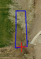
| Acreage: 0.032 |
|
| Last Document:
139593-2004
|
|
| Subdivision Map Filing |
|
| Legal Description:
COM N 67.98 FT & W 120.03 FT FR SE COR. SEC. 18, T5S, R2E, SLB&M.; W 19.22 FT; N 3 DEG 37' 28" E 48.17 FT; N 2 DEG 7' 6" E 19.09 FT; N 1 DEG 25' 38" E 16.67 FT; S 83 DEG 59' 14" E 15.14 FT; S 82.23 FT TO BEG. AREA 0.032 AC. |
|
- Owner Names
- Value History
- Tax History
- Location
- Photos
- Documents
- Aerial Image
| |
----- Real Estate Values ----- |
---Improvements--- |
---Greenbelt--- |
Total |
| Year |
Com |
Res |
Agr |
Tot |
Com |
Res |
Agr |
Tot |
Land |
Homesite |
Tot |
Market Value |
| 2011 |
$0 |
$1,800 |
$0 |
$1,800 |
$0 |
$0 |
$0 |
$0 |
$0 |
$0 |
$0 |
$1,800 |
| 2010 |
$0 |
$1,800 |
$0 |
$1,800 |
$0 |
$0 |
$0 |
$0 |
$0 |
$0 |
$0 |
$1,800 |
| 2009 |
$0 |
$1,800 |
$0 |
$1,800 |
$0 |
$0 |
$0 |
$0 |
$0 |
$0 |
$0 |
$1,800 |
| 2008 |
$0 |
$2,000 |
$0 |
$2,000 |
$0 |
$0 |
$0 |
$0 |
$0 |
$0 |
$0 |
$2,000 |
| 2007 |
$0 |
$2,000 |
$0 |
$2,000 |
$0 |
$0 |
$0 |
$0 |
$0 |
$0 |
$0 |
$2,000 |
| 2006 |
$0 |
$1,650 |
$0 |
$1,650 |
$0 |
$0 |
$0 |
$0 |
$0 |
$0 |
$0 |
$1,650 |
| 2005 |
$0 |
$1,650 |
$0 |
$1,650 |
$0 |
$0 |
$0 |
$0 |
$0 |
$0 |
$0 |
$1,650 |
| Year |
General Taxes |
Adjustments |
Net Taxes |
Fees |
Payments |
Tax Balance* |
Balance Due |
Tax District |
| 2011 |
$23.17 |
$0.00 |
$23.17 |
$0.00 |
|
$0.00
|
$0.00 |
070 - PLEASANT GROVE CITY |
| 2010 |
$21.68 |
$0.00 |
$21.68 |
$0.00 |
|
$0.00
|
$0.00 |
070 - PLEASANT GROVE CITY |
| 2009 |
$20.00 |
$0.00 |
$20.00 |
$0.00 |
|
$0.00
|
$0.00 |
070 - PLEASANT GROVE CITY |
| 2008 |
$20.55 |
$0.00 |
$20.55 |
$0.00 |
|
$0.00
|
$0.00 |
070 - PLEASANT GROVE CITY |
| 2007 |
$19.74 |
$0.00 |
$19.74 |
$0.00 |
|
$0.00
|
$0.00 |
070 - PLEASANT GROVE CITY |
| 2006 |
$17.43 |
$0.00 |
$17.43 |
$0.00 |
|
$0.00
|
$0.00 |
070 - PLEASANT GROVE CITY |
| 2005 |
$20.22 |
$0.00 |
$20.22 |
$0.00 |
|
$0.00
|
$0.00 |
070 - PLEASANT GROVE CITY |
|
*The visual representation is a sum of taxes for the year(s) selected and is for reference only and no liability is assumed for any inaccuracies, incorrect data or variations.
|
|
* Note: Original tax amount (Does not include applicable interest and/or fees).
| Entry # |
Date |
Recorded |
Type |
Party1 (Grantor) |
Party2 (Grantee) |
| 82750-2011 |
08/16/2011 |
11/17/2011 |
S PLAT |
WIGNALL, ANDREW H & GLENNA F (ET AL) |
AUTUMN GROVE PLAT C |
| 82569-2011 |
11/10/2011 |
11/16/2011 |
WD |
HANSGEN, CHRISTINE A & HOWARD H |
HANSGEN, STEVEN |
| 104230-2006 |
06/22/2006 |
08/14/2006 |
QCD |
HULLINGER, ARVIN JAY & LUANA M TEE (ET AL) |
BECKER, JOSH (ET AL) |
| 104052-2006 |
08/03/2006 |
08/11/2006 |
W FARM |
HULLINGER, ARVIN J & LUANA M TEE |
WHOM OF INTEREST |
| 139593-2004 |
12/09/2004 |
12/13/2004 |
WD |
L H PERRY INVESTMENTS LTD |
HANSGEN, CHRISTINE A & HOWARD H |
Main Menu Comments or Concerns on Value/Appraisal - Assessor's Office
Documents/Owner/Parcel information - Recorder's Office
Address Change for Tax Notice
This page was created on 3/9/2025 8:56:06 PM |
