Property Information
| Serial Number: 03:062:0057 |
Serial Life: 2009-2015 |
|
|
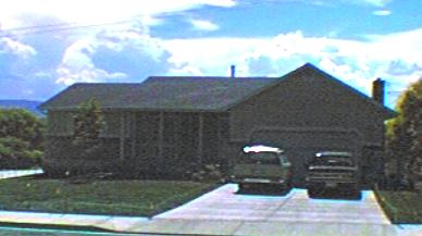
Total Photos: 1
|
| |
|
|
| Property Address: 397 N 700 EAST - PLEASANT GROVE |
|
| Mailing Address: 397 N 700 E PLEASANT GROVE, UT 84062-2447 |
|
| Acreage: 0.366908 |
|
| Last Document:
36513-2008
|
|
| Subdivision Map Filing |
|
| Legal Description:
COM W 30.3 FT & S 0 DEG 33' 0" W 359.9 FT FR INTERSECTION MON. AT 5TH N & 7TH E, PLAT A, PLEASANT GROVE CITY SURVEY; S 0 DEG 33' 0" W 90 FT; N 89 DEG 28' 13" W 111.2 FT; N 0 DEG 45' 18" E 1.89 FT; S 89 DEG 58' 58" W 67.56 FT; N 0 DEG 33' 0" E 88.76 FT; S 89 DEG 28' 13" E 178.75 FT TO BEG. AREA 0.367 AC. |
|
- Owner Names
- Value History
- Tax History
- Location
- Photos
- Documents
- Aerial Image
| |
----- Real Estate Values ----- |
---Improvements--- |
---Greenbelt--- |
Total |
| Year |
Com |
Res |
Agr |
Tot |
Com |
Res |
Agr |
Tot |
Land |
Homesite |
Tot |
Market Value |
| 2015 |
$0 |
$88,200 |
$0 |
$88,200 |
$0 |
$160,200 |
$0 |
$160,200 |
$0 |
$0 |
$0 |
$248,400 |
| 2014 |
$0 |
$85,800 |
$0 |
$85,800 |
$0 |
$152,600 |
$0 |
$152,600 |
$0 |
$0 |
$0 |
$238,400 |
| 2013 |
$0 |
$59,200 |
$0 |
$59,200 |
$0 |
$152,600 |
$0 |
$152,600 |
$0 |
$0 |
$0 |
$211,800 |
| 2012 |
$0 |
$60,500 |
$0 |
$60,500 |
$0 |
$143,500 |
$0 |
$143,500 |
$0 |
$0 |
$0 |
$204,000 |
| 2011 |
$0 |
$54,100 |
$0 |
$54,100 |
$0 |
$158,300 |
$0 |
$158,300 |
$0 |
$0 |
$0 |
$212,400 |
| 2010 |
$0 |
$64,873 |
$0 |
$64,873 |
$0 |
$165,563 |
$0 |
$165,563 |
$0 |
$0 |
$0 |
$230,436 |
| 2009 |
$0 |
$91,800 |
$0 |
$91,800 |
$0 |
$143,700 |
$0 |
$143,700 |
$0 |
$0 |
$0 |
$235,500 |
| Year |
General Taxes |
Adjustments |
Net Taxes |
Fees |
Payments |
Tax Balance* |
Balance Due |
Tax District |
| 2015 |
$1,581.92 |
$0.00 |
$1,581.92 |
$0.00 |
|
$0.00
|
$0.00 |
070 - PLEASANT GROVE CITY |
| 2014 |
$1,532.66 |
$0.00 |
$1,532.66 |
$0.00 |
|
$0.00
|
$0.00 |
070 - PLEASANT GROVE CITY |
| 2013 |
$1,475.81 |
$0.00 |
$1,475.81 |
$0.00 |
|
$0.00
|
$0.00 |
070 - PLEASANT GROVE CITY |
| 2012 |
$1,453.10 |
$0.00 |
$1,453.10 |
$0.00 |
|
$0.00
|
$0.00 |
070 - PLEASANT GROVE CITY |
| 2011 |
$1,503.94 |
$0.00 |
$1,503.94 |
$0.00 |
|
$0.00
|
$0.00 |
070 - PLEASANT GROVE CITY |
| 2010 |
$1,526.71 |
$0.00 |
$1,526.71 |
$0.00 |
|
$0.00
|
$0.00 |
070 - PLEASANT GROVE CITY |
| 2009 |
$1,439.15 |
$0.00 |
$1,439.15 |
$0.00 |
|
$0.00
|
$0.00 |
070 - PLEASANT GROVE CITY |
|
*The visual representation is a sum of taxes for the year(s) selected and is for reference only and no liability is assumed for any inaccuracies, incorrect data or variations.
|
|
* Note: Original tax amount (Does not include applicable interest and/or fees).
| Entry # |
Date |
Recorded |
Type |
Party1 (Grantor) |
Party2 (Grantee) |
| 41082-2015 |
05/08/2015 |
05/13/2015 |
QCD |
JOHNSTON, CLARK SHANE |
JOHNSTON, CLARK SHANE |
| 41081-2015 |
05/08/2015 |
05/13/2015 |
D TR |
JOHNSTON, CLARK SHANE |
ACADEMY MORTGAGE CORPORATION |
| 37011-2015 |
04/30/2015 |
04/30/2015 |
QCD |
JOHNSTON, CLARK SHANE |
JOHNSTON, MELINDA L |
| 29781-2015 |
04/10/2015 |
04/10/2015 |
QCD |
JOHNSTON, MELINDA L |
JOHNSTON, CLARK SHANE |
| 25958-2015 |
03/30/2015 |
03/31/2015 |
TR D |
JOHNSTON, CLARK SHANE |
JOHNSTON, IRENE |
| 25957-2015 |
03/20/2015 |
03/31/2015 |
WD |
BUNKER, DARREN H & KERRI L |
JOHNSTON, CLARK SHANE |
| 25956-2015 |
03/20/2015 |
03/31/2015 |
EASABAN |
SCHELLENBERG, MARTIN & KAREN |
WHOM OF INTEREST |
| 36513-2008 |
03/20/2008 |
03/28/2008 |
FLA |
JOHNSTON, MELINDA L |
BUNKER, DARREN H & KERRI L |
Main Menu Comments or Concerns on Value/Appraisal - Assessor's Office
Documents/Owner/Parcel information - Recorder's Office
Address Change for Tax Notice
This page was created on 2/22/2025 6:25:36 PM |
