Property Information
| Serial Number: 41:333:0013 |
Serial Life: 1996... |
|
|
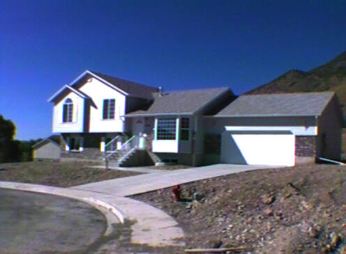
Total Photos: 1
|
| |
|
|
| Property Address: 1756 N 390 EAST - PLEASANT GROVE |
|
| Mailing Address: 1756 N 390 E PLEASANT GROVE, UT 84062-8908 |
|
| Acreage: 0.236 |
|
| Last Document:
50193-2009
|
|
| Subdivision Map Filing |
|
| Legal Description:
LOT 613, PLAT F, HIGH MOUNTAIN MEADOWS SUBDV. AREA 0.236 AC. |
|
- Owner Names
- Value History
- Tax History
- Location
- Photos
- Documents
- Aerial Image
| |
----- Real Estate Values ----- |
---Improvements--- |
---Greenbelt--- |
Total |
| Year |
Com |
Res |
Agr |
Tot |
Com |
Res |
Agr |
Tot |
Land |
Homesite |
Tot |
Market Value |
| 2024 |
$0 |
$234,900 |
$0 |
$234,900 |
$0 |
$268,100 |
$0 |
$268,100 |
$0 |
$0 |
$0 |
$503,000 |
| 2023 |
$0 |
$234,900 |
$0 |
$234,900 |
$0 |
$268,300 |
$0 |
$268,300 |
$0 |
$0 |
$0 |
$503,200 |
| 2022 |
$0 |
$247,800 |
$0 |
$247,800 |
$0 |
$256,700 |
$0 |
$256,700 |
$0 |
$0 |
$0 |
$504,500 |
| 2021 |
$0 |
$154,900 |
$0 |
$154,900 |
$0 |
$203,700 |
$0 |
$203,700 |
$0 |
$0 |
$0 |
$358,600 |
| 2020 |
$0 |
$138,300 |
$0 |
$138,300 |
$0 |
$188,600 |
$0 |
$188,600 |
$0 |
$0 |
$0 |
$326,900 |
| 2019 |
$0 |
$131,000 |
$0 |
$131,000 |
$0 |
$188,600 |
$0 |
$188,600 |
$0 |
$0 |
$0 |
$319,600 |
| 2018 |
$0 |
$123,700 |
$0 |
$123,700 |
$0 |
$173,300 |
$0 |
$173,300 |
$0 |
$0 |
$0 |
$297,000 |
| 2017 |
$0 |
$109,200 |
$0 |
$109,200 |
$0 |
$157,900 |
$0 |
$157,900 |
$0 |
$0 |
$0 |
$267,100 |
| 2016 |
$0 |
$69,100 |
$0 |
$69,100 |
$0 |
$175,400 |
$0 |
$175,400 |
$0 |
$0 |
$0 |
$244,500 |
| 2015 |
$0 |
$69,100 |
$0 |
$69,100 |
$0 |
$159,600 |
$0 |
$159,600 |
$0 |
$0 |
$0 |
$228,700 |
| 2014 |
$0 |
$67,700 |
$0 |
$67,700 |
$0 |
$159,600 |
$0 |
$159,600 |
$0 |
$0 |
$0 |
$227,300 |
| 2013 |
$0 |
$51,900 |
$0 |
$51,900 |
$0 |
$139,700 |
$0 |
$139,700 |
$0 |
$0 |
$0 |
$191,600 |
| 2012 |
$0 |
$75,800 |
$0 |
$75,800 |
$0 |
$102,800 |
$0 |
$102,800 |
$0 |
$0 |
$0 |
$178,600 |
| 2011 |
$0 |
$45,000 |
$0 |
$45,000 |
$0 |
$139,800 |
$0 |
$139,800 |
$0 |
$0 |
$0 |
$184,800 |
| 2010 |
$0 |
$56,236 |
$0 |
$56,236 |
$0 |
$144,160 |
$0 |
$144,160 |
$0 |
$0 |
$0 |
$200,396 |
| 2009 |
$0 |
$69,500 |
$0 |
$69,500 |
$0 |
$132,800 |
$0 |
$132,800 |
$0 |
$0 |
$0 |
$202,300 |
| 2008 |
$0 |
$73,900 |
$0 |
$73,900 |
$0 |
$158,600 |
$0 |
$158,600 |
$0 |
$0 |
$0 |
$232,500 |
| 2007 |
$0 |
$73,900 |
$0 |
$73,900 |
$0 |
$158,600 |
$0 |
$158,600 |
$0 |
$0 |
$0 |
$232,500 |
| 2006 |
$0 |
$38,200 |
$0 |
$38,200 |
$0 |
$168,700 |
$0 |
$168,700 |
$0 |
$0 |
$0 |
$206,900 |
| 2005 |
$0 |
$38,214 |
$0 |
$38,214 |
$0 |
$111,968 |
$0 |
$111,968 |
$0 |
$0 |
$0 |
$150,182 |
| 2004 |
$0 |
$38,214 |
$0 |
$38,214 |
$0 |
$111,968 |
$0 |
$111,968 |
$0 |
$0 |
$0 |
$150,182 |
| 2003 |
$0 |
$38,214 |
$0 |
$38,214 |
$0 |
$111,968 |
$0 |
$111,968 |
$0 |
$0 |
$0 |
$150,182 |
| 2002 |
$0 |
$38,214 |
$0 |
$38,214 |
$0 |
$111,968 |
$0 |
$111,968 |
$0 |
$0 |
$0 |
$150,182 |
| 2001 |
$0 |
$38,214 |
$0 |
$38,214 |
$0 |
$111,968 |
$0 |
$111,968 |
$0 |
$0 |
$0 |
$150,182 |
| 2000 |
$0 |
$35,714 |
$0 |
$35,714 |
$0 |
$98,659 |
$0 |
$98,659 |
$0 |
$0 |
$0 |
$134,373 |
| 1999 |
$0 |
$35,714 |
$0 |
$35,714 |
$0 |
$98,659 |
$0 |
$98,659 |
$0 |
$0 |
$0 |
$134,373 |
| 1998 |
$0 |
$31,605 |
$0 |
$31,605 |
$0 |
$87,309 |
$0 |
$87,309 |
$0 |
$0 |
$0 |
$118,914 |
| 1997 |
$0 |
$31,605 |
$0 |
$31,605 |
$0 |
$87,309 |
$0 |
$87,309 |
$0 |
$0 |
$0 |
$118,914 |
| 1996 |
$0 |
$31,000 |
$0 |
$31,000 |
$0 |
$0 |
$0 |
$0 |
$0 |
$0 |
$0 |
$31,000 |
| Year |
General Taxes |
Adjustments |
Net Taxes |
Fees |
Payments |
Tax Balance* |
Balance Due |
Tax District |
| 2025 |
$0.00 |
$0.00 |
$0.00 |
$0.00 |
|
$0.00
|
$0.00 |
070 - PLEASANT GROVE CITY |
| 2024 |
$2,370.61 |
$0.00 |
$2,370.61 |
$0.00 |
|
$0.00
|
$0.00 |
070 - PLEASANT GROVE CITY |
| 2023 |
$2,265.28 |
($52.58) |
$2,212.70 |
$0.00 |
|
$0.00
|
$0.00 |
070 - PLEASANT GROVE CITY |
| 2022 |
$2,282.51 |
$0.00 |
$2,282.51 |
$0.00 |
|
$0.00
|
$0.00 |
070 - PLEASANT GROVE CITY |
| 2021 |
$1,937.39 |
$0.00 |
$1,937.39 |
$0.00 |
|
$0.00
|
$0.00 |
070 - PLEASANT GROVE CITY |
| 2020 |
$1,801.55 |
$0.00 |
$1,801.55 |
$0.00 |
|
$0.00
|
$0.00 |
070 - PLEASANT GROVE CITY |
| 2019 |
$1,703.13 |
$0.00 |
$1,703.13 |
$0.00 |
|
$0.00
|
$0.00 |
070 - PLEASANT GROVE CITY |
| 2018 |
$1,673.85 |
$0.00 |
$1,673.85 |
$0.00 |
|
$0.00
|
$0.00 |
070 - PLEASANT GROVE CITY |
| 2017 |
$1,555.14 |
$0.00 |
$1,555.14 |
$0.00 |
|
$0.00
|
$0.00 |
070 - PLEASANT GROVE CITY |
| 2016 |
$1,474.52 |
$0.00 |
$1,474.52 |
$0.00 |
|
$0.00
|
$0.00 |
070 - PLEASANT GROVE CITY |
| 2015 |
$1,456.46 |
$0.00 |
$1,456.46 |
$0.00 |
|
$0.00
|
$0.00 |
070 - PLEASANT GROVE CITY |
| 2014 |
$1,461.30 |
$0.00 |
$1,461.30 |
$0.00 |
|
$0.00
|
$0.00 |
070 - PLEASANT GROVE CITY |
| 2013 |
$1,335.06 |
$0.00 |
$1,335.06 |
$0.00 |
|
$0.00
|
$0.00 |
070 - PLEASANT GROVE CITY |
| 2012 |
$1,272.18 |
$0.00 |
$1,272.18 |
$0.00 |
|
$0.00
|
$0.00 |
070 - PLEASANT GROVE CITY |
| 2011 |
$1,308.51 |
$0.00 |
$1,308.51 |
$0.00 |
|
$0.00
|
$0.00 |
070 - PLEASANT GROVE CITY |
| 2010 |
$1,327.69 |
$0.00 |
$1,327.69 |
$0.00 |
|
$0.00
|
$0.00 |
070 - PLEASANT GROVE CITY |
| 2009 |
$1,236.27 |
$0.00 |
$1,236.27 |
$0.00 |
|
$0.00
|
$0.00 |
070 - PLEASANT GROVE CITY |
| 2008 |
$1,314.04 |
$0.00 |
$1,314.04 |
$0.00 |
|
$0.00
|
$0.00 |
070 - PLEASANT GROVE CITY |
| 2007 |
$1,262.00 |
$0.00 |
$1,262.00 |
$0.00 |
|
$0.00
|
$0.00 |
070 - PLEASANT GROVE CITY |
| 2006 |
$1,202.02 |
$0.00 |
$1,202.02 |
$0.00 |
|
$0.00
|
$0.00 |
070 - PLEASANT GROVE CITY |
| 2005 |
$1,012.26 |
$0.00 |
$1,012.26 |
$0.00 |
|
$0.00
|
$0.00 |
070 - PLEASANT GROVE CITY |
| 2004 |
$1,024.98 |
$0.00 |
$1,024.98 |
$0.00 |
|
$0.00
|
$0.00 |
070 - PLEASANT GROVE CITY |
| 2003 |
$1,016.48 |
$0.00 |
$1,016.48 |
$0.00 |
|
$0.00
|
$0.00 |
070 - PLEASANT GROVE CITY |
| 2002 |
$938.91 |
$0.00 |
$938.91 |
$0.00 |
|
$0.00
|
$0.00 |
070 - PLEASANT GROVE CITY |
| 2001 |
$926.69 |
$0.00 |
$926.69 |
$0.00 |
|
$0.00
|
$0.00 |
070 - PLEASANT GROVE CITY |
| 2000 |
$861.29 |
$0.00 |
$861.29 |
$0.00 |
|
$0.00
|
$0.00 |
070 - PLEASANT GROVE CITY |
| 1999 |
$870.75 |
$0.00 |
$870.75 |
$0.00 |
|
$0.00
|
$0.00 |
070 - PLEASANT GROVE CITY |
| 1998 |
$755.54 |
$0.00 |
$755.54 |
$0.00 |
|
$0.00
|
$0.00 |
070 - PLEASANT GROVE CITY |
| 1997 |
$728.26 |
$0.00 |
$728.26 |
$0.00 |
|
$0.00
|
$0.00 |
070 - PLEASANT GROVE CITY |
| 1996 |
$341.06 |
$0.00 |
$341.06 |
$0.00 |
|
$0.00
|
$0.00 |
070 - PLEASANT GROVE CITY |
|
*The visual representation is a sum of taxes for the year(s) selected and is for reference only and no liability is assumed for any inaccuracies, incorrect data or variations.
|
|
* Note: Original tax amount (Does not include applicable interest and/or fees).
| Entry # |
Date |
Recorded |
Type |
Party1 (Grantor) |
Party2 (Grantee) |
| 123435-2022 |
12/08/2022 |
12/08/2022 |
QCD |
WARNICK, KYLE F & MARIA S |
WARNICK, KYLE F & MARIA S TEE (ET AL) |
| 127664-2020 |
08/17/2020 |
08/25/2020 |
RSUBTEE |
MORTGAGE ELECTRONIC REGISTRATION SYSTEMS INC (ET AL) |
WARNICK, KYLE F & MARIA S |
| 100789-2020 |
07/10/2020 |
07/15/2020 |
D TR |
WARNICK, KYLE F & MARIA S |
DATA MORTGAGE INC DBA (ET AL) |
| 74306-2016 |
08/01/2016 |
08/08/2016 |
REC |
CITIBANK TEE |
WARNICK, KYLE F & MARIA S |
| 74305-2016 |
08/01/2016 |
08/08/2016 |
SUB TEE |
MORTGAGE ELECTRONIC REGISTRATION SYSTEMS INC |
CITIBANK SUCTEE |
| 47497-2016 |
05/23/2016 |
05/27/2016 |
D TR |
WARNICK, KYLE F & MARIA S |
SECURITY HOME MORTGAGE LLC |
| 3229-2016 |
01/04/2016 |
01/13/2016 |
REC |
CITIBANK TEE |
WARNICK, KYLE F & MARIA S |
| 3228-2016 |
01/04/2016 |
01/13/2016 |
SUB TEE |
MORTGAGE ELECTRONIC REGISTRATION SYSTEMS INC |
CITIBANK SUCTEE |
| 97754-2015 |
10/19/2015 |
10/28/2015 |
D TR |
WARNICK, KYLE F & MARIA S |
CITIBANK |
| 54913-2009 |
05/13/2009 |
05/18/2009 |
RSUBTEE |
MORTGAGE ELECTRONIC REGISTRATION SYSTEMS INC (ET AL) |
WARNICK, KYLE F & MARIA S |
| 50194-2009 |
04/30/2009 |
05/06/2009 |
D TR |
WARNICK, KYLE F & MARIA S |
PROVIDENT FUNDING ASSOCIATES LP |
| 50193-2009 |
04/30/2009 |
05/06/2009 |
WD |
WARNICK, KYLE F & MARIA S |
WARNICK, KYLE F & MARIA S |
| 52645-2008 |
04/25/2008 |
05/02/2008 |
REC |
CITICORP TRUST BANK TEE |
WARNICK, KYLE F & MARIA S |
| 52644-2008 |
04/25/2008 |
05/02/2008 |
SUB TEE |
MORTGAGE ELECTRONIC REGISTRATION SYSTEMS INC |
CITICORP TRUST BANK SUCTEE |
| 13993-2008 |
01/31/2008 |
02/06/2008 |
D TR |
WARNICK, KYLE F & MARIA S |
PROVIDENT FUNDING ASSOCIATES LP |
| 7265-2006 |
01/13/2006 |
01/20/2006 |
D TR |
WARNICK, KYLE F & MARIA S |
CITIMORTGAGE INC |
| 78750-2004 |
03/29/2004 |
07/09/2004 |
REC |
INWEST TITLE SERVICES INC |
WARNICK, KYLE F & MARIA S |
| 55097-2004 |
05/01/2004 |
05/13/2004 |
RSUBTEE |
NATIONAL CITY MORTGAGE CO (ET AL) |
WARNICK, KYLE F & MARIA S |
| 34403-2004 |
03/23/2004 |
03/29/2004 |
D TR |
WARNICK, KYLE F & MARIA S |
CHEVY CHASE BANK |
| 141861-2002 |
09/27/2002 |
11/25/2002 |
SUB TEE |
GMAC MORTGAGE CORPORATION |
RIVERS, ROD SUCTEE |
| 141860-2002 |
10/28/2002 |
11/25/2002 |
REC |
RIVERS, ROD TEE |
MCFARLAND, KRIST RAY & SHERYL KAY |
| 112696-2002 |
09/20/2002 |
09/25/2002 |
AS |
AMERICAN LENDING NETWORK INC |
NATIONAL CITY MORTGAGE CO |
| 112695-2002 |
09/20/2002 |
09/25/2002 |
D TR |
WARNICK, KYLE F & MARIA S |
AMERICAN LENDING NETWORK INC |
| 137602-1998 |
09/01/1998 |
12/31/1998 |
AS |
ACCU BANC MORTGAGE CORPORATION DBA (ET AL) |
GMAC MORTGAGE CORPORATION |
| 83399-1998 |
08/05/1998 |
08/19/1998 |
REC |
ZIONS FIRST NATIONAL BANK TEE |
WARNICK, KYLE F & MARIA S |
| 54792-1998 |
05/26/1998 |
06/01/1998 |
AS |
SECURITY STATE MORTGAGE (ET AL) |
ACCUBANC MORTGAGE CORPORATION DBA (ET AL) |
| 54791-1998 |
05/27/1998 |
06/01/1998 |
D TR |
WARNICK, KYLE F & MARIA S |
SECURITY STATE MORTGAGE |
| 67645-1996 |
08/09/1996 |
08/19/1996 |
T FN ST |
ZIONS MORTGAGE COMPANY |
WOODSIDE HOMES CORPORATION |
| 67644-1996 |
08/09/1996 |
08/19/1996 |
R ASLS |
ZIONS MORTGAGE COMPANY |
WOODSIDE HOMES CORPORATION |
| 67643-1996 |
08/09/1996 |
08/19/1996 |
REC |
ZIONS FIRST NATIONAL BANK TEE |
WOODSIDE HOMES CORPORATION |
| 67642-1996 |
08/09/1996 |
08/19/1996 |
REC |
ZIONS FIRST NATIONAL BANK TEE |
WOODSIDE HOMES CORPORATION |
| 65599-1996 |
08/07/1996 |
08/09/1996 |
D TR |
WARNICK, KYLE F & MARIA S |
ZIONS MORTGAGE COMPANY |
| 65598-1996 |
06/14/1996 |
08/09/1996 |
WD |
WOODSIDE HOMES CORPORATION |
WARNICK, KYLE F & MARIA S |
| 6572-1996 |
10/20/1996 |
01/25/1996 |
RES COV |
WOODSIDE HOMES CORPORATION |
WHOM OF INTEREST |
| 78399-1995 |
07/18/1995 |
11/14/1995 |
S PLAT |
WOODSIDE HOMES CORP |
HIGH MOUNTAIN MEADOWS PLAT F |
Main Menu Comments or Concerns on Value/Appraisal - Assessor's Office
Documents/Owner/Parcel information - Recorder's Office
Address Change for Tax Notice
This page was created on 2/28/2025 2:19:49 AM |
