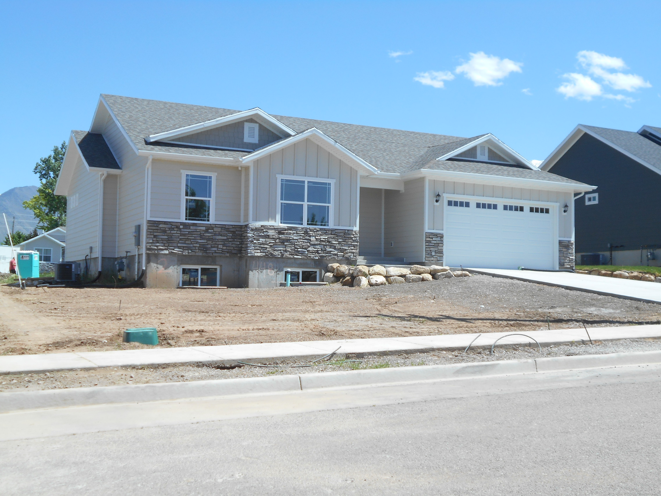
Property Information
| Serial Number: 65:444:0002 |
Serial Life: 2016... |
|
|

Total Photos: 2
|
| |
|
|
| Property Address: 448 N 500 EAST - PAYSON |
|
| Mailing Address: 531 W 465 S SPANISH FORK, UT 84660 |
|
| Acreage: 0.173457 |
|
| Last Document:
64877-2015
|
|
| Subdivision Map Filing |
|
| Legal Description:
LOT 2, PLAT A, COWAN CORNER SUB AREA 0.173 AC. |
|
- Owner Names
- Value History
- Tax History
- Location
- Photos
- Documents
- Aerial Image
| |
----- Real Estate Values ----- |
---Improvements--- |
---Greenbelt--- |
Total |
| Year |
Com |
Res |
Agr |
Tot |
Com |
Res |
Agr |
Tot |
Land |
Homesite |
Tot |
Market Value |
| 2024 |
$0 |
$100,900 |
$0 |
$100,900 |
$0 |
$327,000 |
$0 |
$327,000 |
$0 |
$0 |
$0 |
$427,900 |
| 2023 |
$0 |
$100,800 |
$0 |
$100,800 |
$0 |
$335,800 |
$0 |
$335,800 |
$0 |
$0 |
$0 |
$436,600 |
| 2022 |
$0 |
$107,500 |
$0 |
$107,500 |
$0 |
$293,000 |
$0 |
$293,000 |
$0 |
$0 |
$0 |
$400,500 |
| 2021 |
$0 |
$86,000 |
$0 |
$86,000 |
$0 |
$213,900 |
$0 |
$213,900 |
$0 |
$0 |
$0 |
$299,900 |
| 2020 |
$0 |
$78,200 |
$0 |
$78,200 |
$0 |
$200,300 |
$0 |
$200,300 |
$0 |
$0 |
$0 |
$278,500 |
| 2019 |
$0 |
$70,100 |
$0 |
$70,100 |
$0 |
$185,300 |
$0 |
$185,300 |
$0 |
$0 |
$0 |
$255,400 |
| 2018 |
$0 |
$62,600 |
$0 |
$62,600 |
$0 |
$86,300 |
$0 |
$86,300 |
$0 |
$0 |
$0 |
$148,900 |
| 2016 |
$0 |
$42,200 |
$0 |
$42,200 |
$0 |
$0 |
$0 |
$0 |
$0 |
$0 |
$0 |
$42,200 |
| Year |
General Taxes |
Adjustments |
Net Taxes |
Fees |
Payments |
Tax Balance* |
Balance Due |
Tax District |
| 2025 |
$0.00 |
$0.00 |
$0.00 |
$0.00 |
|
$0.00
|
$0.00 |
170 - PAYSON CITY |
| 2024 |
$2,312.50 |
$0.00 |
$2,312.50 |
$0.00 |
|
$0.00
|
$0.00 |
170 - PAYSON CITY |
| 2023 |
$2,353.03 |
$0.00 |
$2,353.03 |
$0.00 |
|
$0.00
|
$0.00 |
170 - PAYSON CITY |
| 2022 |
$2,194.60 |
$0.00 |
$2,194.60 |
$0.00 |
|
$0.00
|
$0.00 |
170 - PAYSON CITY |
| 2021 |
$1,862.89 |
$0.00 |
$1,862.89 |
$0.00 |
|
$0.00
|
$0.00 |
170 - PAYSON CITY |
| 2020 |
$1,768.25 |
$0.00 |
$1,768.25 |
$0.00 |
|
$0.00
|
$0.00 |
170 - PAYSON CITY |
| 2019 |
$1,581.69 |
$0.00 |
$1,581.69 |
$0.00 |
|
$0.00
|
$0.00 |
170 - PAYSON CITY |
| 2018 |
$956.78 |
$349.35 |
$1,306.13 |
$0.00 |
|
$0.00
|
$0.00 |
170 - PAYSON CITY |
|
*The visual representation is a sum of taxes for the year(s) selected and is for reference only and no liability is assumed for any inaccuracies, incorrect data or variations.
|
|
* Note: Original tax amount (Does not include applicable interest and/or fees).
| Entry # |
Date |
Recorded |
Type |
Party1 (Grantor) |
Party2 (Grantee) |
| 148562-2021 |
08/14/2021 |
08/25/2021 |
RC |
AMERICA FIRST FEDERAL CREDIT UNION |
WHOM OF INTEREST |
| 140589-2021 |
08/10/2021 |
08/11/2021 |
D TR |
BANKS, KAMERON STEVEN HUFF & MECKELLE |
AMERICA FIRST FEDERAL CREDIT UNION |
| 61783-2017 |
06/27/2017 |
06/27/2017 |
REC |
BACKMAN TITLE SERVICES LTD BY TEE (ET AL) |
RURAL HOUSING DEVELOPMENT CORPORATION DBA (ET AL) |
| 61782-2017 |
06/27/2017 |
06/27/2017 |
REC |
BACKMAN TITLE SERVICES LTD BY TEE (ET AL) |
RURAL HOUSING DEVELOPMENT CORPORATION DBA (ET AL) |
| 57025-2017 |
06/12/2017 |
06/13/2017 |
RES COV |
BANKS, KAMERON STEVEN HUFF & MECKELLE |
WHOM OF INTEREST |
| 57024-2017 |
06/12/2017 |
06/13/2017 |
D TR |
BANKS, KAMERON STEVEN HUFF & MECKELLE |
UNITED STATES DEPARTMENT OF AGRICULTURE |
| 57023-2017 |
06/13/2017 |
06/13/2017 |
WD |
RURAL HOUSING DEVELOPMENT CORPORATION DBA (ET AL) |
BANKS, KAMERON STEVEN HUFF & MECKELLE |
| 83356-2016 |
08/30/2016 |
08/30/2016 |
R LN |
STAKER & PARSON COMPANIES |
RURAL HOUSING DEVELOPMENT CORPORATION |
| 25891-2016 |
03/28/2016 |
03/28/2016 |
N LN |
RURAL HOUSING DEVELOPMENT CORPORATION |
STAKER & PARSON COMPANIES |
| 64877-2015 |
07/15/2015 |
07/20/2015 |
S PLAT |
RURAL HOUSING DEVELOPMENT CORPORATION DBA (ET AL) |
COWAN CORNER PLAT A |
Main Menu Comments or Concerns on Value/Appraisal - Assessor's Office
Documents/Owner/Parcel information - Recorder's Office
Address Change for Tax Notice
This page was created on 12/25/2024 6:22:39 AM |