Property Information
| Serial Number: 07:137:0026 |
Serial Life: 2009... |
|
|
Total Photos: 2
|
| |
|
|
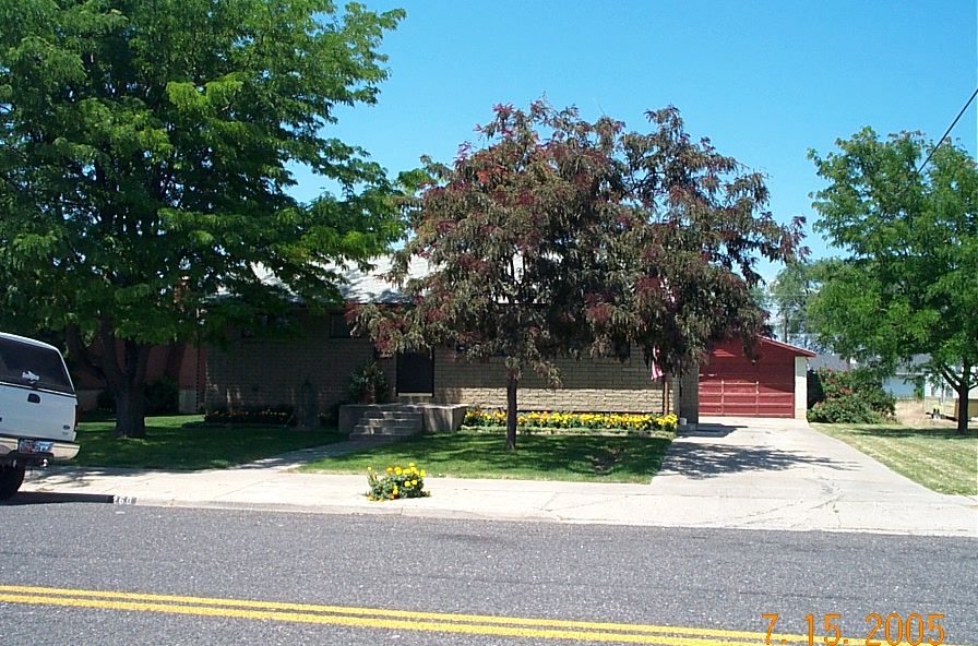
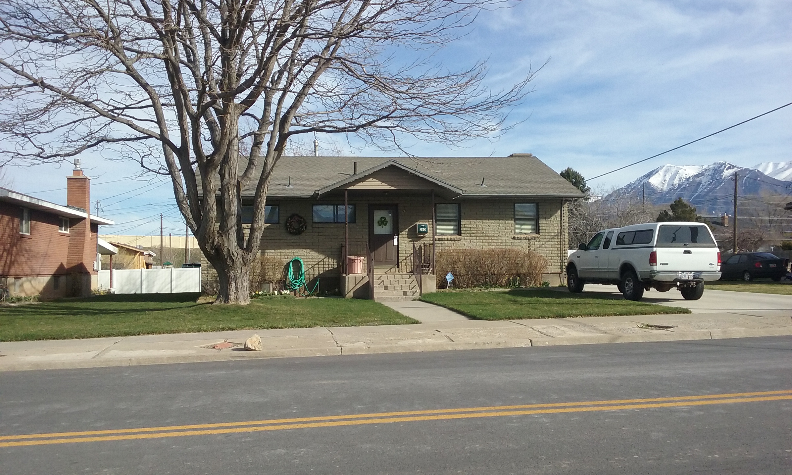
| Property Address: 260 W 800 NORTH - SPANISH FORK |
|
| Mailing Address: 346 S NEBO DR SPANISH FORK, UT 84660-2531 |
|
| Acreage: 0.146685 |
|
| Last Document:
41707-2023
|
|
| Subdivision Map Filing |
|
| Legal Description:
COM N 89 DEG 32' 58" W 199.58 FT FR SE COR. LOT 1, BLK. 137, PLAT A, SPANISH FORK CITY SURVEY; N 89 DEG 32' 58" W 64.42 FT; N 0 DEG 27' 2" E 99 FT; S 89 DEG 32' 58" E 64.67 FT; S 0 DEG 35' 58" W 99 FT TO BEG (ROT. TO BLA BLK BEARING) TO BEG. AREA 0.147 AC. |
|
- Owner Names
- Value History
- Tax History
- Location
- Photos
- Documents
- Aerial Image
| |
----- Real Estate Values ----- |
---Improvements--- |
---Greenbelt--- |
Total |
| Year |
Com |
Res |
Agr |
Tot |
Com |
Res |
Agr |
Tot |
Land |
Homesite |
Tot |
Market Value |
| 2024 |
$0 |
$129,100 |
$0 |
$129,100 |
$0 |
$274,000 |
$0 |
$274,000 |
$0 |
$0 |
$0 |
$403,100 |
| 2023 |
$0 |
$129,100 |
$0 |
$129,100 |
$0 |
$279,100 |
$0 |
$279,100 |
$0 |
$0 |
$0 |
$408,200 |
| 2022 |
$0 |
$137,700 |
$0 |
$137,700 |
$0 |
$266,000 |
$0 |
$266,000 |
$0 |
$0 |
$0 |
$403,700 |
| 2021 |
$0 |
$78,700 |
$0 |
$78,700 |
$0 |
$237,700 |
$0 |
$237,700 |
$0 |
$0 |
$0 |
$316,400 |
| 2020 |
$0 |
$65,600 |
$0 |
$65,600 |
$0 |
$214,100 |
$0 |
$214,100 |
$0 |
$0 |
$0 |
$279,700 |
| 2019 |
$0 |
$65,600 |
$0 |
$65,600 |
$0 |
$191,000 |
$0 |
$191,000 |
$0 |
$0 |
$0 |
$256,600 |
| 2018 |
$0 |
$65,600 |
$0 |
$65,600 |
$0 |
$166,100 |
$0 |
$166,100 |
$0 |
$0 |
$0 |
$231,700 |
| 2017 |
$0 |
$54,400 |
$0 |
$54,400 |
$0 |
$151,800 |
$0 |
$151,800 |
$0 |
$0 |
$0 |
$206,200 |
| 2016 |
$0 |
$38,000 |
$0 |
$38,000 |
$0 |
$151,800 |
$0 |
$151,800 |
$0 |
$0 |
$0 |
$189,800 |
| 2015 |
$0 |
$37,400 |
$0 |
$37,400 |
$0 |
$136,300 |
$0 |
$136,300 |
$0 |
$0 |
$0 |
$173,700 |
| 2014 |
$0 |
$39,300 |
$0 |
$39,300 |
$0 |
$118,500 |
$0 |
$118,500 |
$0 |
$0 |
$0 |
$157,800 |
| 2013 |
$0 |
$39,100 |
$0 |
$39,100 |
$0 |
$101,300 |
$0 |
$101,300 |
$0 |
$0 |
$0 |
$140,400 |
| 2012 |
$0 |
$38,900 |
$0 |
$38,900 |
$0 |
$103,500 |
$0 |
$103,500 |
$0 |
$0 |
$0 |
$142,400 |
| 2011 |
$0 |
$34,600 |
$0 |
$34,600 |
$0 |
$116,000 |
$0 |
$116,000 |
$0 |
$0 |
$0 |
$150,600 |
| 2010 |
$0 |
$37,898 |
$0 |
$37,898 |
$0 |
$125,485 |
$0 |
$125,485 |
$0 |
$0 |
$0 |
$163,383 |
| 2009 |
$0 |
$56,000 |
$0 |
$56,000 |
$0 |
$110,700 |
$0 |
$110,700 |
$0 |
$0 |
$0 |
$166,700 |
| Year |
General Taxes |
Adjustments |
Net Taxes |
Fees |
Payments |
Tax Balance* |
Balance Due |
Tax District |
| 2025 |
$0.00 |
$0.00 |
$0.00 |
$0.00 |
|
$0.00
|
$0.00 |
150 - SPANISH FORK CITY |
| 2024 |
$2,150.98 |
$0.00 |
$2,150.98 |
$0.00 |
|
$0.00
|
$0.00 |
150 - SPANISH FORK CITY |
| 2023 |
$2,175.73 |
$0.00 |
$2,175.73 |
$0.00 |
|
$0.00
|
$0.00 |
150 - SPANISH FORK CITY |
| 2022 |
$2,193.93 |
$0.00 |
$2,193.93 |
$0.00 |
|
$0.00
|
$0.00 |
150 - SPANISH FORK CITY |
| 2021 |
$1,954.24 |
$0.00 |
$1,954.24 |
$0.00 |
|
$0.00
|
$0.00 |
150 - SPANISH FORK CITY |
| 2020 |
$1,776.95 |
$0.00 |
$1,776.95 |
$0.00 |
|
$0.00
|
$0.00 |
150 - SPANISH FORK CITY |
| 2019 |
$1,549.47 |
$0.00 |
$1,549.47 |
$0.00 |
|
$0.00
|
$0.00 |
150 - SPANISH FORK CITY |
| 2018 |
$1,447.41 |
$0.00 |
$1,447.41 |
$0.00 |
|
$0.00
|
$0.00 |
150 - SPANISH FORK CITY |
| 2017 |
$1,318.05 |
$0.00 |
$1,318.05 |
$0.00 |
|
$0.00
|
$0.00 |
150 - SPANISH FORK CITY |
| 2016 |
$1,229.51 |
$0.00 |
$1,229.51 |
$0.00 |
|
$0.00
|
$0.00 |
150 - SPANISH FORK CITY |
| 2015 |
$1,138.78 |
$0.00 |
$1,138.78 |
$0.00 |
|
$0.00
|
$0.00 |
150 - SPANISH FORK CITY |
| 2014 |
$1,030.80 |
$0.00 |
$1,030.80 |
$0.00 |
|
$0.00
|
$0.00 |
150 - SPANISH FORK CITY |
| 2013 |
$961.54 |
$0.00 |
$961.54 |
$0.00 |
|
$0.00
|
$0.00 |
150 - SPANISH FORK CITY |
| 2012 |
$988.01 |
$0.00 |
$988.01 |
$0.00 |
|
$0.00
|
$0.00 |
150 - SPANISH FORK CITY |
| 2011 |
$1,021.63 |
$0.00 |
$1,021.63 |
$0.00 |
|
$0.00
|
$0.00 |
150 - SPANISH FORK CITY |
| 2010 |
$1,080.31 |
$0.00 |
$1,080.31 |
$0.00 |
|
$0.00
|
$0.00 |
150 - SPANISH FORK CITY |
| 2009 |
$1,043.38 |
$0.00 |
$1,043.38 |
$0.00 |
|
$0.00
|
$0.00 |
150 - SPANISH FORK CITY |
|
*The visual representation is a sum of taxes for the year(s) selected and is for reference only and no liability is assumed for any inaccuracies, incorrect data or variations.
|
|
* Note: Original tax amount (Does not include applicable interest and/or fees).
| Entry # |
Date |
Recorded |
Type |
Party1 (Grantor) |
Party2 (Grantee) |
| 41707-2023 |
06/23/2023 |
06/28/2023 |
SP WD |
NELSON, BILL B & DAVID F SUCTEE (ET AL) |
VANAUSDAL, BRET C & ANN N TEE (ET AL) |
| 41706-2023 |
06/23/2023 |
06/28/2023 |
AF DC |
NELSON, MAGGIE LENORE & LENORE B AKA (ET AL) |
NELSON, BILL B & DAVID F SUCTEE (ET AL) |
| 37256-2023 |
06/06/2023 |
06/09/2023 |
SP WD |
NELSON, BILL B & DAVID F SUCTEE (ET AL) |
VANAUSDAL, BRET C & ANN N TEE (ET AL) |
| 37255-2023 |
06/06/2023 |
06/09/2023 |
AF DC |
NELSON, MAGGIE LENORE & LENORE B AKA (ET AL) |
NELSON, BILL B & DAVID F SUCTEE (ET AL) |
| 3187-2015 |
12/04/2014 |
01/14/2015 |
QCD |
UNITED STATES OF AMERICA |
SOUTH UTAH VALLEY ELECTRIC SERVICE DISTRICT |
| 114949-2008 |
10/20/2008 |
10/22/2008 |
CT |
STATE OF UTAH |
WHOM OF INTEREST |
| 107508-2008 |
09/30/2008 |
09/30/2008 |
RESOL |
BOARD OF COUNTY COMMISSIONERS UTAH COUNTY |
WHOM OF INTEREST |
| 88588-2008 |
05/08/2008 |
08/07/2008 |
BLA |
JONES, HEATHER |
JONES, LENORE B TEE (ET AL) |
Main Menu Comments or Concerns on Value/Appraisal - Assessor's Office
Documents/Owner/Parcel information - Recorder's Office
Address Change for Tax Notice
This page was created on 3/8/2025 11:11:28 AM |