Property Information
mobile view
| Serial Number: 10:026:0010 |
Serial Life: 2006... |
|
|
 Total Photos: 3
|
| |
|
|
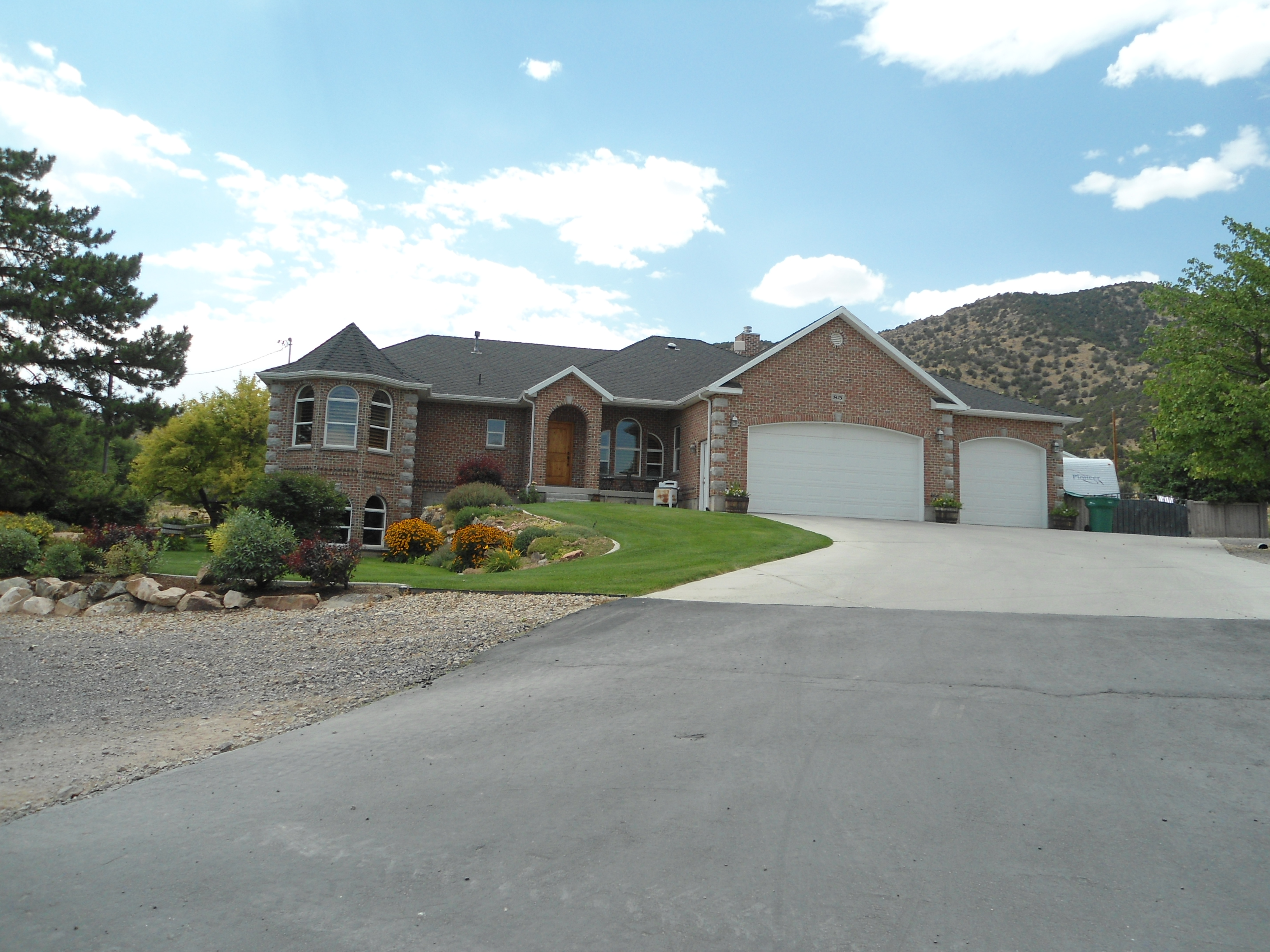
| Property Address: 85 N 100 WEST - CEDAR FORT |
|
| Mailing Address: PO BOX 420 CEDAR VALLEY, UT 84013-0420 |
|
| Acreage: 0.842 |
|
| Last Document:
89696-2005
|
|
| Subdivision Map Filing |
|
| Taxing Description:
COM AT NE COR. BLK. 12, PLAT A, CEDAR FORT CITY SURVEY; S 1 DEG 10' 41" W 135.19 FT; N 89 DEG 5' 45" W 271.23 FT; N 1 DEG 2' 21" E 135.03 FT; S 89 DEG 7' 40" E 271.56 FT TO BEG. AREA 0.842 AC.
*Taxing description NOT FOR LEGAL DOCUMENTS
|
|
- Owner Names
- Value History
- Tax History
- Location
- Photos
- Documents
- Aerial Image
| |
----- Real Estate Values ----- |
---Improvements--- |
---Greenbelt--- |
Total |
| Year |
Com |
Res |
Agr |
Tot |
Com |
Res |
Agr |
Tot |
Land |
Homesite |
Tot |
Market Value |
| 2024 |
$0 |
$154,900 |
$0 |
$154,900 |
$0 |
$612,000 |
$0 |
$612,000 |
$0 |
$0 |
$0 |
$766,900 |
| 2023 |
$0 |
$154,900 |
$0 |
$154,900 |
$0 |
$689,900 |
$0 |
$689,900 |
$0 |
$0 |
$0 |
$844,800 |
| 2022 |
$0 |
$160,200 |
$0 |
$160,200 |
$0 |
$638,900 |
$0 |
$638,900 |
$0 |
$0 |
$0 |
$799,100 |
| 2021 |
$0 |
$114,400 |
$0 |
$114,400 |
$0 |
$554,600 |
$0 |
$554,600 |
$0 |
$0 |
$0 |
$669,000 |
| 2020 |
$0 |
$105,900 |
$0 |
$105,900 |
$0 |
$508,800 |
$0 |
$508,800 |
$0 |
$0 |
$0 |
$614,700 |
| 2019 |
$0 |
$105,900 |
$0 |
$105,900 |
$0 |
$508,800 |
$0 |
$508,800 |
$0 |
$0 |
$0 |
$614,700 |
| 2018 |
$0 |
$67,400 |
$0 |
$67,400 |
$0 |
$508,800 |
$0 |
$508,800 |
$0 |
$0 |
$0 |
$576,200 |
| 2017 |
$0 |
$57,800 |
$0 |
$57,800 |
$0 |
$442,400 |
$0 |
$442,400 |
$0 |
$0 |
$0 |
$500,200 |
| 2016 |
$0 |
$46,200 |
$0 |
$46,200 |
$0 |
$411,400 |
$0 |
$411,400 |
$0 |
$0 |
$0 |
$457,600 |
| 2015 |
$0 |
$40,400 |
$0 |
$40,400 |
$0 |
$357,700 |
$0 |
$357,700 |
$0 |
$0 |
$0 |
$398,100 |
| 2014 |
$0 |
$33,800 |
$0 |
$33,800 |
$0 |
$311,000 |
$0 |
$311,000 |
$0 |
$0 |
$0 |
$344,800 |
| 2013 |
$0 |
$33,600 |
$0 |
$33,600 |
$0 |
$311,000 |
$0 |
$311,000 |
$0 |
$0 |
$0 |
$344,600 |
| 2012 |
$0 |
$26,500 |
$0 |
$26,500 |
$0 |
$345,500 |
$0 |
$345,500 |
$0 |
$0 |
$0 |
$372,000 |
| 2011 |
$0 |
$26,500 |
$0 |
$26,500 |
$0 |
$345,500 |
$0 |
$345,500 |
$0 |
$0 |
$0 |
$372,000 |
| 2010 |
$0 |
$26,500 |
$0 |
$26,500 |
$0 |
$353,098 |
$0 |
$353,098 |
$0 |
$0 |
$0 |
$379,598 |
| 2009 |
$0 |
$26,500 |
$0 |
$26,500 |
$0 |
$46,500 |
$0 |
$46,500 |
$0 |
$0 |
$0 |
$73,000 |
| 2008 |
$0 |
$26,500 |
$0 |
$26,500 |
$0 |
$46,500 |
$0 |
$46,500 |
$0 |
$0 |
$0 |
$73,000 |
| 2007 |
$0 |
$26,500 |
$0 |
$26,500 |
$0 |
$46,500 |
$0 |
$46,500 |
$0 |
$0 |
$0 |
$73,000 |
| 2006 |
$0 |
$23,000 |
$0 |
$23,000 |
$0 |
$42,272 |
$0 |
$42,272 |
$0 |
$0 |
$0 |
$65,272 |
| Year |
General Taxes |
Adjustments |
Net Taxes |
Fees |
Payments |
Tax Balance* |
Balance Due |
Tax District |
| 2025 |
$0.00 |
$0.00 |
$0.00 |
$0.00 |
|
$0.00
|
$0.00 |
050 - CEDAR FORT CITY |
| 2024 |
$0.00 |
$0.00 |
$0.00 |
$0.00 |
|
$0.00
|
$0.00 |
050 - CEDAR FORT CITY |
| 2023 |
$3,343.08 |
$0.00 |
$3,343.08 |
$0.00 |
|
$0.00
|
$0.00 |
050 - CEDAR FORT CITY |
| 2022 |
$3,249.26 |
$0.00 |
$3,249.26 |
$0.00 |
|
$0.00
|
$0.00 |
050 - CEDAR FORT CITY |
| 2021 |
$3,283.22 |
$0.00 |
$3,283.22 |
$0.00 |
|
$0.00
|
$0.00 |
050 - CEDAR FORT CITY |
| 2020 |
$3,067.45 |
$0.00 |
$3,067.45 |
$0.00 |
|
$0.00
|
$0.00 |
050 - CEDAR FORT CITY |
| 2019 |
$2,920.72 |
$0.00 |
$2,920.72 |
$0.00 |
|
$0.00
|
$0.00 |
050 - CEDAR FORT CITY |
| 2018 |
$2,903.21 |
$0.00 |
$2,903.21 |
$0.00 |
|
$0.00
|
$0.00 |
050 - CEDAR FORT CITY |
| 2017 |
$2,602.54 |
$0.00 |
$2,602.54 |
$0.00 |
|
$0.00
|
$0.00 |
050 - CEDAR FORT CITY |
| 2016 |
$2,568.14 |
$0.00 |
$2,568.14 |
$0.00 |
|
$0.00
|
$0.00 |
050 - CEDAR FORT CITY |
| 2015 |
$2,360.12 |
$0.00 |
$2,360.12 |
$0.00 |
|
$0.00
|
$0.00 |
050 - CEDAR FORT CITY |
| 2014 |
$2,053.80 |
$0.00 |
$2,053.80 |
$0.00 |
|
$0.00
|
$0.00 |
050 - CEDAR FORT CITY |
| 2013 |
$2,214.28 |
$0.00 |
$2,214.28 |
$0.00 |
|
$0.00
|
$0.00 |
050 - CEDAR FORT CITY |
| 2012 |
$2,429.63 |
$0.00 |
$2,429.63 |
$0.00 |
|
$0.00
|
$0.00 |
050 - CEDAR FORT CITY |
| 2011 |
$2,421.24 |
$0.00 |
$2,421.24 |
$0.00 |
|
$0.00
|
$0.00 |
050 - CEDAR FORT CITY |
| 2010 |
$2,347.93 |
$0.00 |
$2,347.93 |
$0.00 |
|
$0.00
|
$0.00 |
050 - CEDAR FORT CITY |
| 2009 |
$418.52 |
$0.00 |
$418.52 |
$0.00 |
|
$0.00
|
$0.00 |
050 - CEDAR FORT CITY |
| 2008 |
$392.19 |
$0.00 |
$392.19 |
$0.00 |
|
$0.00
|
$0.00 |
050 - CEDAR FORT CITY |
| 2007 |
$369.10 |
$0.00 |
$369.10 |
$0.00 |
|
$0.00
|
$0.00 |
050 - CEDAR FORT CITY |
| 2006 |
$325.07 |
$0.00 |
$325.07 |
$0.00 |
|
$0.00
|
$0.00 |
050 - CEDAR FORT CITY |
* Note: Original tax amount (Does not include applicable interest and/or fees).
| Entry # |
Date |
Recorded |
Type |
Party1 (Grantor) |
Party2 (Grantee) |
| 94218-2018 |
10/01/2018 |
10/01/2018 |
REC |
BANK OF AMERICAN FORK TEE |
ADAMS, LORI TEE (ET AL) |
| 114949-2008 |
10/20/2008 |
10/22/2008 |
CT |
STATE OF UTAH |
WHOM OF INTEREST |
| 107508-2008 |
09/30/2008 |
09/30/2008 |
RESOL |
BOARD OF COUNTY COMMISSIONERS UTAH COUNTY |
WHOM OF INTEREST |
| 89176-2008 |
08/06/2006 |
08/11/2008 |
D TR |
ADAMS, LORI TEE (ET AL) |
BANK OF AMERICAN FORK |
| 97407-2005 |
09/01/2005 |
09/01/2005 |
R FARM |
UTAH COUNTY TREASURER |
COOK, WILLIAM H & CLYDE H (ET AL) |
| 89696-2005 |
08/11/2005 |
08/15/2005 |
WD |
COOK, CLYDE H & CAROLYN |
ADAMS, LORI TEE (ET AL) |
Main Menu Comments or Concerns on Value/Appraisal - Assessor's Office
Documents/Owner/Parcel information - Recorder's Office
Address Change for Tax Notice
This page was created on 9/10/2024 11:21:04 PM |

