Property Information
mobile view
| Serial Number: 11:037:0326 |
Serial Life: 2011-2019 |
|
|
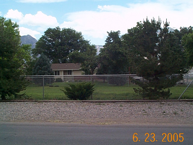
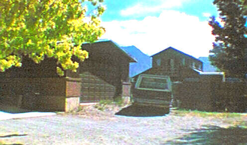
Total Photos: 2
|
| |
|
|
| Property Address: 10460 N 6000 WEST - HIGHLAND |
|
| Mailing Address: 610 WESTFIELD RD ALPINE, UT 84004-1501 |
|
| Acreage: 6.407971 |
|
| Last Document:
1822-2010
|
|
| Subdivision Map Filing |
|
| Taxing Description:
COM N 89 DEG 46' 0" E 580.99 FT FR S 1/4 COR. SEC. 35, T4S, R1E, SLB&M.; N 0 DEG 24' 0" W 211 FT; S 89 DEG 46' 0" W 152 FT; N 0 DEG 24' 0" W 139.5 FT; S 89 DEG 46' 0" W 396 FT; N 0 DEG 24' 0" W 291.1 FT; N 87 DEG 10' 0" E 685.63 FT; S 0 DEG 24' 0" E 672.71 FT; S 89 DEG 46' 0" W 137.01 FT TO BEG. AREA 6.408 AC.
*Taxing description NOT FOR LEGAL DOCUMENTS
|
|
- Owner Names
- Value History
- Tax History
- Location
- Photos
- Documents
- Aerial Image
| |
----- Real Estate Values ----- |
---Improvements--- |
---Greenbelt--- |
Total |
| Year |
Com |
Res |
Agr |
Tot |
Com |
Res |
Agr |
Tot |
Land |
Homesite |
Tot |
Market Value |
| 2019 |
$0 |
$205,000 |
$649,000 |
$854,000 |
$0 |
$305,000 |
$0 |
$305,000 |
$2,101 |
$65,000 |
$67,101 |
$1,159,000 |
| 2018 |
$0 |
$200,000 |
$649,000 |
$849,000 |
$0 |
$265,200 |
$0 |
$265,200 |
$2,347 |
$65,000 |
$67,347 |
$1,114,200 |
| 2017 |
$0 |
$180,000 |
$540,800 |
$720,800 |
$0 |
$230,600 |
$0 |
$230,600 |
$2,458 |
$65,000 |
$67,458 |
$951,400 |
| 2016 |
$0 |
$135,000 |
$405,600 |
$540,600 |
$0 |
$192,200 |
$0 |
$192,200 |
$2,409 |
$65,000 |
$67,409 |
$732,800 |
| 2015 |
$0 |
$125,000 |
$405,600 |
$530,600 |
$0 |
$190,400 |
$0 |
$190,400 |
$2,396 |
$65,000 |
$67,396 |
$721,000 |
| 2014 |
$0 |
$123,000 |
$405,600 |
$528,600 |
$0 |
$190,400 |
$0 |
$190,400 |
$2,482 |
$65,000 |
$67,482 |
$719,000 |
| 2013 |
$0 |
$120,000 |
$342,600 |
$462,600 |
$0 |
$190,400 |
$0 |
$190,400 |
$2,630 |
$65,000 |
$67,630 |
$653,000 |
| 2012 |
$0 |
$120,000 |
$243,400 |
$363,400 |
$0 |
$248,000 |
$0 |
$248,000 |
$0 |
$0 |
$0 |
$611,400 |
| 2011 |
$0 |
$163,000 |
$613,136 |
$776,136 |
$0 |
$248,274 |
$0 |
$248,274 |
$0 |
$0 |
$0 |
$1,024,410 |
| Year |
General Taxes |
Adjustments |
Net Taxes |
Fees |
Payments |
Tax Balance* |
Balance Due |
Tax District |
| 2019 |
$1,893.38 |
$0.00 |
$1,893.38 |
$0.00 |
|
$0.00
|
$0.00 |
045 - HIGHLAND CITY |
| 2018 |
$1,782.54 |
$0.00 |
$1,782.54 |
$0.00 |
|
$0.00
|
$0.00 |
045 - HIGHLAND CITY |
| 2017 |
$1,647.90 |
$0.00 |
$1,647.90 |
$0.00 |
|
$0.00
|
$0.00 |
045 - HIGHLAND CITY |
| 2016 |
$1,537.10 |
$0.00 |
$1,537.10 |
$0.00 |
|
$0.00
|
$0.00 |
045 - HIGHLAND CITY |
| 2015 |
$1,610.39 |
$0.00 |
$1,610.39 |
$0.00 |
|
$0.00
|
$0.00 |
045 - HIGHLAND CITY |
| 2014 |
$1,625.79 |
$0.00 |
$1,625.79 |
$0.00 |
|
$0.00
|
$0.00 |
045 - HIGHLAND CITY |
| 2013 |
$1,762.71 |
$0.00 |
$1,762.71 |
$0.00 |
|
$0.00
|
$0.00 |
045 - HIGHLAND CITY |
| 2012 |
$5,635.36 |
$0.00 |
$5,635.36 |
$0.00 |
|
$0.00
|
$0.00 |
045 - HIGHLAND CITY |
| 2011 |
$10,594.11 |
$0.00 |
$10,594.11 |
$0.00 |
|
$0.00
|
$0.00 |
045 - HIGHLAND CITY |
* Note: Original tax amount (Does not include applicable interest and/or fees).
| Entry # |
Date |
Recorded |
Type |
Party1 (Grantor) |
Party2 (Grantee) |
| 121155-2019 |
10/01/2019 |
11/19/2019 |
S PLAT |
ARABIAN MEADOWS LLC |
ARABIAN MEADOWS PLAT A |
| 100150-2012 |
10/18/2012 |
11/14/2012 |
FARM |
ARABIAN MEADOWS LLC |
WHOM OF INTEREST |
| 1822-2010 |
12/29/2009 |
01/08/2010 |
QCD |
ARABIAN MEADOWS LLC |
ARABIAN MEADOWS LLC |
Main Menu Comments or Concerns on Value/Appraisal - Assessor's Office
Documents/Owner/Parcel information - Recorder's Office
Address Change for Tax Notice
This page was created on 8/5/2024 5:13:03 PM |