Property Information
mobile view
| Serial Number: 19:012:0010 |
Serial Life: 1977... |
|
|
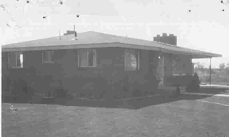 Total Photos: 1
|
| |
|
|
| Property Address: 1810 S 400 EAST - OREM |
|
| Mailing Address: 1810 S 400 E OREM, UT 84058-7935 |
|
| Acreage: 0.28 |
|
| Last Document:
55082-1993
|
|
| Subdivision Map Filing |
|
| Taxing Description:
COM N 240 FT FR NE COR LOT 11, RIDING TRACT WHICH PT IS ALSO 1235 FT N ALONG 1/4 SEC LINE & 33 FT W OF S 1/4 COR OF SEC 26, T6S, R2E, SLM; W 136 FT; N 68.72 FT; S 89 DEG 37'E 130.14 FT; N 00 DEG 42'W 17.15 FT; E 39.07 FT; S 85 FT; W 33 FT TO BEG. AREA .28 ACRE.
*Taxing description NOT FOR LEGAL DOCUMENTS
|
|
- Owner Names
- Value History
- Tax History
- Location
- Photos
- Documents
- Aerial Image
| 2026... |
|
JOHNSON, DOROTHY E |
|
| 2026NV |
|
JOHNSON FAMILY TRUST 08-12-1993 |
|
| 2026NV |
|
JOHNSON, DOROTHY E |
|
| 1994-2025 |
|
JOHNSON, BETH ALLRED |
|
| 1994-2025 |
|
JOHNSON, ELWOOD J |
|
| 1987-1993 |
|
JOHNSON, BETH A |
|
| 1987-1993 |
|
JOHNSON, ELWOOD J |
|
| 1984-1986 |
|
JOHNSON, BETH A |
|
| 1984-1986 |
|
JOHNSON, ELWOOD J |
|
| 1977-1983 |
|
JOHNSON, BETH A |
|
| 1977-1983 |
|
JOHNSON, ELWOOD J |
|
| |
----- Real Estate Values ----- |
---Improvements--- |
---Greenbelt--- |
Total |
| Year |
Com |
Res |
Agr |
Tot |
Com |
Res |
Agr |
Tot |
Land |
Homesite |
Tot |
Market Value |
| 2024 |
$0 |
$226,100 |
$0 |
$226,100 |
$0 |
$213,700 |
$0 |
$213,700 |
$0 |
$0 |
$0 |
$439,800 |
| 2023 |
$0 |
$226,100 |
$0 |
$226,100 |
$0 |
$211,000 |
$0 |
$211,000 |
$0 |
$0 |
$0 |
$437,100 |
| 2022 |
$0 |
$241,100 |
$0 |
$241,100 |
$0 |
$182,400 |
$0 |
$182,400 |
$0 |
$0 |
$0 |
$423,500 |
| 2021 |
$0 |
$141,800 |
$0 |
$141,800 |
$0 |
$168,900 |
$0 |
$168,900 |
$0 |
$0 |
$0 |
$310,700 |
| 2020 |
$0 |
$113,400 |
$0 |
$113,400 |
$0 |
$164,000 |
$0 |
$164,000 |
$0 |
$0 |
$0 |
$277,400 |
| 2019 |
$0 |
$98,200 |
$0 |
$98,200 |
$0 |
$148,100 |
$0 |
$148,100 |
$0 |
$0 |
$0 |
$246,300 |
| 2018 |
$0 |
$94,500 |
$0 |
$94,500 |
$0 |
$128,800 |
$0 |
$128,800 |
$0 |
$0 |
$0 |
$223,300 |
| 2017 |
$0 |
$86,900 |
$0 |
$86,900 |
$0 |
$117,400 |
$0 |
$117,400 |
$0 |
$0 |
$0 |
$204,300 |
| 2016 |
$0 |
$75,600 |
$0 |
$75,600 |
$0 |
$108,500 |
$0 |
$108,500 |
$0 |
$0 |
$0 |
$184,100 |
| 2015 |
$0 |
$75,600 |
$0 |
$75,600 |
$0 |
$97,900 |
$0 |
$97,900 |
$0 |
$0 |
$0 |
$173,500 |
| 2014 |
$0 |
$77,800 |
$0 |
$77,800 |
$0 |
$85,200 |
$0 |
$85,200 |
$0 |
$0 |
$0 |
$163,000 |
| 2013 |
$0 |
$79,900 |
$0 |
$79,900 |
$0 |
$74,100 |
$0 |
$74,100 |
$0 |
$0 |
$0 |
$154,000 |
| 2012 |
$0 |
$68,300 |
$0 |
$68,300 |
$0 |
$65,600 |
$0 |
$65,600 |
$0 |
$0 |
$0 |
$133,900 |
| 2011 |
$0 |
$74,500 |
$0 |
$74,500 |
$0 |
$63,600 |
$0 |
$63,600 |
$0 |
$0 |
$0 |
$138,100 |
| 2010 |
$0 |
$80,286 |
$0 |
$80,286 |
$0 |
$66,505 |
$0 |
$66,505 |
$0 |
$0 |
$0 |
$146,791 |
| 2009 |
$0 |
$98,600 |
$0 |
$98,600 |
$0 |
$52,700 |
$0 |
$52,700 |
$0 |
$0 |
$0 |
$151,300 |
| 2008 |
$0 |
$98,600 |
$0 |
$98,600 |
$0 |
$69,300 |
$0 |
$69,300 |
$0 |
$0 |
$0 |
$167,900 |
| 2007 |
$0 |
$102,700 |
$0 |
$102,700 |
$0 |
$72,200 |
$0 |
$72,200 |
$0 |
$0 |
$0 |
$174,900 |
| 2006 |
$0 |
$58,700 |
$0 |
$58,700 |
$0 |
$75,600 |
$0 |
$75,600 |
$0 |
$0 |
$0 |
$134,300 |
| 2005 |
$0 |
$55,937 |
$0 |
$55,937 |
$0 |
$72,036 |
$0 |
$72,036 |
$0 |
$0 |
$0 |
$127,973 |
| 2004 |
$0 |
$55,937 |
$0 |
$55,937 |
$0 |
$72,036 |
$0 |
$72,036 |
$0 |
$0 |
$0 |
$127,973 |
| 2003 |
$0 |
$55,937 |
$0 |
$55,937 |
$0 |
$72,036 |
$0 |
$72,036 |
$0 |
$0 |
$0 |
$127,973 |
| 2002 |
$0 |
$55,937 |
$0 |
$55,937 |
$0 |
$72,036 |
$0 |
$72,036 |
$0 |
$0 |
$0 |
$127,973 |
| 2001 |
$0 |
$55,937 |
$0 |
$55,937 |
$0 |
$72,036 |
$0 |
$72,036 |
$0 |
$0 |
$0 |
$127,973 |
| 2000 |
$0 |
$52,278 |
$0 |
$52,278 |
$0 |
$64,543 |
$0 |
$64,543 |
$0 |
$0 |
$0 |
$116,821 |
| 1999 |
$0 |
$48,858 |
$0 |
$48,858 |
$0 |
$60,321 |
$0 |
$60,321 |
$0 |
$0 |
$0 |
$109,179 |
| 1998 |
$0 |
$48,858 |
$0 |
$48,858 |
$0 |
$60,321 |
$0 |
$60,321 |
$0 |
$0 |
$0 |
$109,179 |
| 1997 |
$0 |
$48,858 |
$0 |
$48,858 |
$0 |
$60,321 |
$0 |
$60,321 |
$0 |
$0 |
$0 |
$109,179 |
| 1996 |
$0 |
$41,702 |
$0 |
$41,702 |
$0 |
$51,486 |
$0 |
$51,486 |
$0 |
$0 |
$0 |
$93,188 |
| 1995 |
$0 |
$37,911 |
$0 |
$37,911 |
$0 |
$51,486 |
$0 |
$51,486 |
$0 |
$0 |
$0 |
$89,397 |
| 1994 |
$0 |
$22,170 |
$0 |
$22,170 |
$0 |
$41,521 |
$0 |
$41,521 |
$0 |
$0 |
$0 |
$63,691 |
| 1993 |
$0 |
$22,170 |
$0 |
$22,170 |
$0 |
$41,521 |
$0 |
$41,521 |
$0 |
$0 |
$0 |
$63,691 |
| 1992 |
$0 |
$20,339 |
$0 |
$20,339 |
$0 |
$38,093 |
$0 |
$38,093 |
$0 |
$0 |
$0 |
$58,432 |
| 1991 |
$0 |
$17,841 |
$0 |
$17,841 |
$0 |
$32,568 |
$0 |
$32,568 |
$0 |
$0 |
$0 |
$50,409 |
| 1990 |
$0 |
$17,841 |
$0 |
$17,841 |
$0 |
$32,568 |
$0 |
$32,568 |
$0 |
$0 |
$0 |
$50,409 |
| 1989 |
$0 |
$17,841 |
$0 |
$17,841 |
$0 |
$32,568 |
$0 |
$32,568 |
$0 |
$0 |
$0 |
$50,409 |
| 1988 |
$0 |
$17,842 |
$0 |
$17,842 |
$0 |
$33,738 |
$0 |
$33,738 |
$0 |
$0 |
$0 |
$51,580 |
| 1987 |
$0 |
$17,842 |
$0 |
$17,842 |
$0 |
$44,492 |
$0 |
$44,492 |
$0 |
$0 |
$0 |
$62,334 |
| 1986 |
$0 |
$17,842 |
$0 |
$17,842 |
$0 |
$44,493 |
$0 |
$44,493 |
$0 |
$0 |
$0 |
$62,335 |
| 1985 |
$0 |
$17,842 |
$0 |
$17,842 |
$0 |
$44,491 |
$0 |
$44,491 |
$0 |
$0 |
$0 |
$62,333 |
| 1984 |
$0 |
$18,025 |
$0 |
$18,025 |
$0 |
$44,942 |
$0 |
$44,942 |
$0 |
$0 |
$0 |
$62,967 |
| Year |
General Taxes |
Adjustments |
Net Taxes |
Fees |
Payments |
Tax Balance* |
Balance Due |
Tax District |
| 2025 |
$0.00 |
$0.00 |
$0.00 |
$0.00 |
|
$0.00
|
$0.00 |
090 - OREM CITY |
| 2024 |
$1,978.18 |
$0.00 |
$1,978.18 |
$0.00 |
|
$0.00
|
$0.00 |
090 - OREM CITY |
| 2023 |
$1,829.24 |
$0.00 |
$1,829.24 |
$0.00 |
|
$0.00
|
$0.00 |
090 - OREM CITY |
| 2022 |
$1,829.39 |
$0.00 |
$1,829.39 |
$0.00 |
|
$0.00
|
$0.00 |
090 - OREM CITY |
| 2021 |
$1,611.10 |
$0.00 |
$1,611.10 |
$0.00 |
|
$0.00
|
$0.00 |
090 - OREM CITY |
| 2020 |
$1,463.60 |
$0.00 |
$1,463.60 |
$0.00 |
|
$0.00
|
$0.00 |
090 - OREM CITY |
| 2019 |
$1,249.66 |
$0.00 |
$1,249.66 |
$0.00 |
|
$0.00
|
$0.00 |
090 - OREM CITY |
| 2018 |
$1,185.78 |
$0.00 |
$1,185.78 |
$0.00 |
|
$0.00
|
$0.00 |
090 - OREM CITY |
| 2017 |
$1,113.87 |
$0.00 |
$1,113.87 |
$0.00 |
|
$0.00
|
$0.00 |
090 - OREM CITY |
| 2016 |
$1,088.49 |
$0.00 |
$1,088.49 |
$0.00 |
|
$0.00
|
$0.00 |
090 - OREM CITY |
| 2015 |
$1,084.70 |
$0.00 |
$1,084.70 |
$0.00 |
|
$0.00
|
$0.00 |
090 - OREM CITY |
| 2014 |
$1,023.71 |
$0.00 |
$1,023.71 |
$0.00 |
|
$0.00
|
$0.00 |
090 - OREM CITY |
| 2013 |
$1,043.00 |
$0.00 |
$1,043.00 |
$0.00 |
|
$0.00
|
$0.00 |
090 - OREM CITY |
| 2012 |
$925.57 |
$0.00 |
$925.57 |
$0.00 |
|
$0.00
|
$0.00 |
090 - OREM CITY |
| 2011 |
$950.05 |
$0.00 |
$950.05 |
$0.00 |
|
$0.00
|
$0.00 |
090 - OREM CITY |
| 2010 |
$945.41 |
$0.00 |
$945.41 |
$0.00 |
|
$0.00
|
$0.00 |
090 - OREM CITY |
| 2009 |
$903.30 |
$0.00 |
$903.30 |
$0.00 |
|
$0.00
|
$0.00 |
090 - OREM CITY |
| 2008 |
$928.90 |
$0.00 |
$928.90 |
$0.00 |
|
$0.00
|
$0.00 |
090 - OREM CITY |
| 2007 |
$956.56 |
$0.00 |
$956.56 |
$0.00 |
|
$0.00
|
$0.00 |
090 - OREM CITY |
| 2006 |
$782.16 |
$0.00 |
$782.16 |
$0.00 |
|
$0.00
|
$0.00 |
090 - OREM CITY |
| 2005 |
$841.24 |
$0.00 |
$841.24 |
$0.00 |
|
$0.00
|
$0.00 |
090 - OREM CITY |
| 2004 |
$826.32 |
$0.00 |
$826.32 |
$0.00 |
|
$0.00
|
$0.00 |
090 - OREM CITY |
| 2003 |
$801.83 |
$0.00 |
$801.83 |
$0.00 |
|
$0.00
|
$0.00 |
090 - OREM CITY |
| 2002 |
$732.78 |
$0.00 |
$732.78 |
$0.00 |
|
$0.00
|
$0.00 |
090 - OREM CITY |
| 2001 |
$725.74 |
$0.00 |
$725.74 |
$0.00 |
|
$0.00
|
$0.00 |
090 - OREM CITY |
| 2000 |
$684.99 |
$0.00 |
$684.99 |
$0.00 |
|
$0.00
|
$0.00 |
090 - OREM CITY |
| 1999 |
$659.10 |
$0.00 |
$659.10 |
$0.00 |
|
$0.00
|
$0.00 |
090 - OREM CITY |
| 1998 |
$622.35 |
$0.00 |
$622.35 |
$0.00 |
|
$0.00
|
$0.00 |
090 - OREM CITY |
| 1997 |
$619.77 |
$0.00 |
$619.77 |
$0.00 |
|
$0.00
|
$0.00 |
090 - OREM CITY |
| 1996 |
$483.26 |
$0.00 |
$483.26 |
$0.00 |
|
$0.00
|
$0.00 |
090 - OREM CITY |
| 1995 |
$524.62 |
$0.00 |
$524.62 |
$0.00 |
|
$0.00
|
$0.00 |
090 - OREM CITY |
| 1994 |
$595.51 |
$0.00 |
$595.51 |
$0.00 |
|
$0.00
|
$0.00 |
090 - OREM CITY |
| 1993 |
$527.03 |
$0.00 |
$527.03 |
$0.00 |
|
$0.00
|
$0.00 |
090 - OREM CITY |
| 1992 |
$487.49 |
$0.00 |
$487.49 |
$0.00 |
|
$0.00
|
$0.00 |
090 - OREM CITY |
| 1991 |
$439.70 |
$0.00 |
$439.70 |
$0.00 |
|
$0.00
|
$0.00 |
090 - OREM CITY |
| 1990 |
$422.69 |
$0.00 |
$422.69 |
$0.00 |
|
$0.00
|
$0.00 |
090 - OREM CITY |
| 1989 |
$430.79 |
$0.00 |
$430.79 |
$0.00 |
|
$0.00
|
$0.00 |
090 - OREM CITY |
| 1988 |
$439.74 |
$0.00 |
$439.74 |
$0.00 |
|
$0.00
|
$0.00 |
090 - OREM CITY |
| 1987 |
$522.63 |
$0.00 |
$522.63 |
$0.00 |
|
$0.00
|
$0.00 |
090 - OREM CITY |
| 1986 |
$515.60 |
$0.00 |
$515.60 |
$0.00 |
|
$0.00
|
$0.00 |
090 - OREM CITY |
| 1985 |
$518.66 |
$0.00 |
$518.66 |
$0.00 |
|
$0.00
|
$0.00 |
090 - OREM CITY |
| 1984 |
$513.88 |
$0.00 |
$513.88 |
$0.00 |
|
$0.00
|
$0.00 |
090 - OREM CITY |
* Note: Original tax amount (Does not include applicable interest and/or fees).
| Entry # |
Date |
Recorded |
Type |
Party1 (Grantor) |
Party2 (Grantee) |
| 19964-2025 |
03/17/2025 |
03/21/2025 |
D TR |
JOHNSON, DOROTHY E |
UTAH COMMUNITY FEDERAL CREDIT UNION |
| 19963-2025 |
03/17/2025 |
03/21/2025 |
WD |
JOHNSON, DOROTHY E SUCTEE (ET AL) |
JOHNSON, DOROTHY E |
| 19962-2025 |
03/17/2025 |
03/21/2025 |
AF DC |
JOHNSON, ELWOOD J & BETH ALLRED DEC (ET AL) |
JOHNSON, DOROTHY E TEE (ET AL) |
| 92806-1993 |
09/14/1993 |
12/20/1993 |
IDORDIN |
OREM CITY OF |
SPECIAL IMPROVEMENT LIGHTING DISTRICT #36 |
| 55082-1993 |
08/12/1993 |
08/13/1993 |
WD |
JOHNSON, ELWOOD J & BETH ALLRED (ET AL) |
JOHNSON, ELWOOD J & BETH ALLRED TEE |
| 42925-1980 |
12/05/1980 |
12/12/1980 |
REC |
FIRST AMERICAN TITLE COMPANY OF UTAH FKA (ET AL) |
JOHNSON, ELWOOD J & BETH A |
Main Menu Comments or Concerns on Value/Appraisal - Assessor's Office
Documents/Owner/Parcel information - Recorder's Office
Address Change for Tax Notice
This page was created on 4/22/2025 11:23:51 PM |