Property Information
mobile view
| Serial Number: 25:025:0085 |
Serial Life: 2017... |
|
|
 Total Photos: 1
|
| |
|
|
| Property Address: |
|
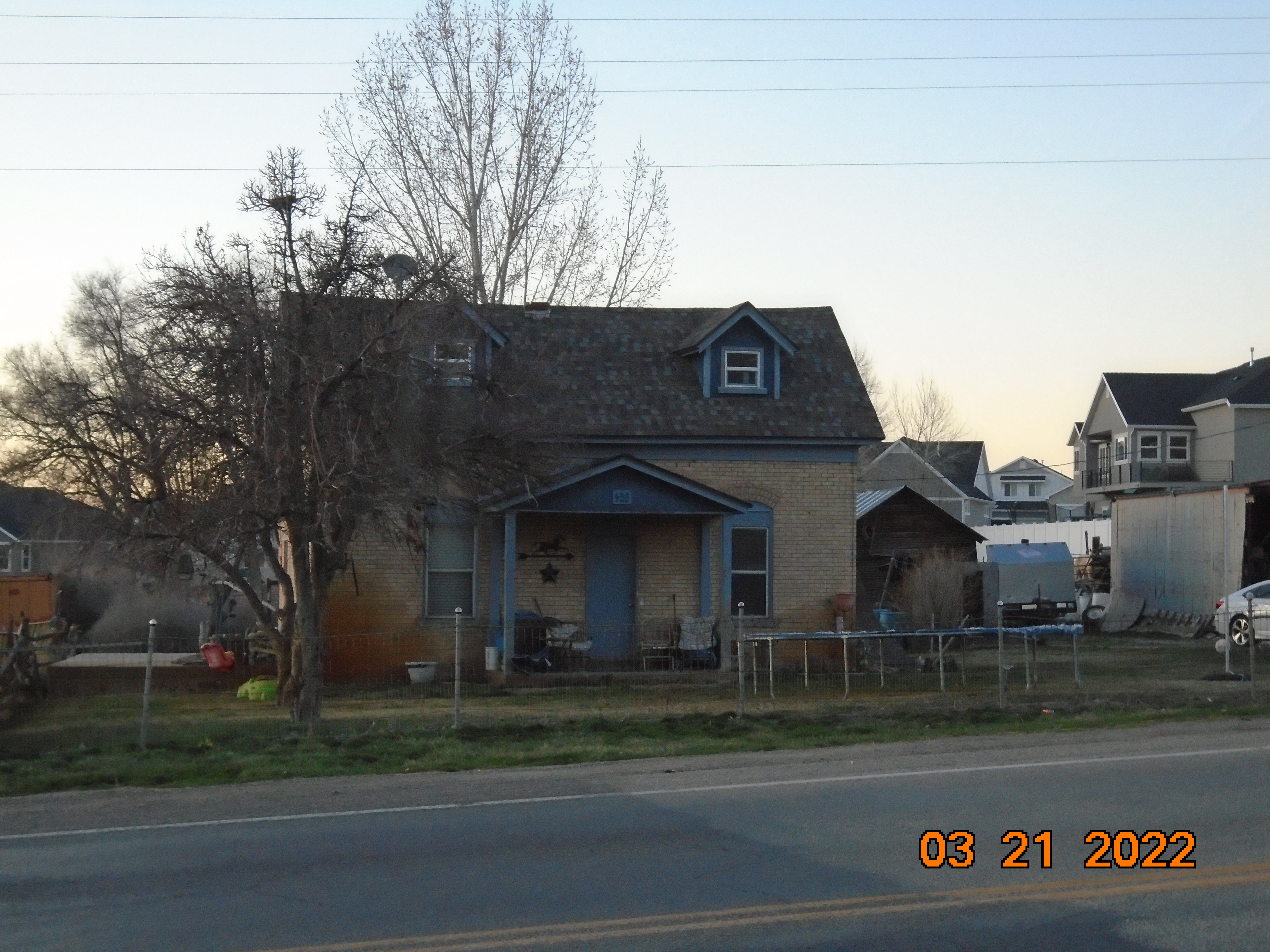
| Mailing Address: 456 ARROWHEAD TRL SPANISH FORK, UT 84660 |
|
| Acreage: 2.242666 |
|
| Last Document:
50466-2016
|
|
| Subdivision Map Filing |
|
| Taxing Description:
COM N 1358.1 FT & W 459.38 FT FR S 1/4 COR. SEC. 25, T8S, R3E, SLB&M.; S 84 DEG 24' 44" E 87.88 FT; S 22 DEG 12' 42" E 24.58 FT; W 2.47 FT; S 20 DEG 52' 47" E 69.42 FT; S 0 DEG 0' 2" E 268.15 FT; S 63 DEG 20' 45" W 129.17 FT; S 55 DEG 45' 11" W 199.99 FT; S 48 DEG 9' 30" W 127.6 FT; N 22 DEG 30' 0" E 671.02 FT TO BEG. AREA 2.243 AC.
*Taxing description NOT FOR LEGAL DOCUMENTS
|
|
- Owner Names
- Value History
- Tax History
- Location
- Photos
- Documents
- Aerial Image
| |
----- Real Estate Values ----- |
---Improvements--- |
---Greenbelt--- |
Total |
| Year |
Com |
Res |
Agr |
Tot |
Com |
Res |
Agr |
Tot |
Land |
Homesite |
Tot |
Market Value |
| 2024 |
$0 |
$212,700 |
$91,400 |
$304,100 |
$0 |
$188,100 |
$0 |
$188,100 |
$0 |
$0 |
$0 |
$492,200 |
| 2023 |
$0 |
$212,700 |
$91,400 |
$304,100 |
$0 |
$188,200 |
$0 |
$188,200 |
$0 |
$0 |
$0 |
$492,300 |
| 2022 |
$0 |
$226,800 |
$97,400 |
$324,200 |
$0 |
$181,700 |
$0 |
$181,700 |
$0 |
$0 |
$0 |
$505,900 |
| 2021 |
$0 |
$162,000 |
$48,700 |
$210,700 |
$0 |
$136,600 |
$0 |
$136,600 |
$0 |
$0 |
$0 |
$347,300 |
| 2020 |
$0 |
$135,000 |
$43,500 |
$178,500 |
$0 |
$136,600 |
$0 |
$136,600 |
$0 |
$0 |
$0 |
$315,100 |
| 2019 |
$0 |
$110,000 |
$37,300 |
$147,300 |
$0 |
$125,500 |
$0 |
$125,500 |
$0 |
$0 |
$0 |
$272,800 |
| 2018 |
$0 |
$100,000 |
$37,300 |
$137,300 |
$0 |
$109,100 |
$0 |
$109,100 |
$0 |
$0 |
$0 |
$246,400 |
| 2017 |
$0 |
$100,000 |
$37,300 |
$137,300 |
$0 |
$90,900 |
$0 |
$90,900 |
$0 |
$0 |
$0 |
$228,200 |
| Year |
General Taxes |
Adjustments |
Net Taxes |
Fees |
Payments |
Tax Balance* |
Balance Due |
Tax District |
| 2025 |
$0.00 |
$0.00 |
$0.00 |
$0.00 |
|
$0.00
|
$0.00 |
120 - NEBO SCHOOL DIST S/A 6-7-8 |
| 2024 |
$3,119.65 |
$0.00 |
$3,119.65 |
$0.00 |
|
|
Click for Payoff
|
120 - NEBO SCHOOL DIST S/A 6-7-8 |
| 2023 |
$3,117.70 |
$0.00 |
$3,117.70 |
$0.00 |
|
$0.00
|
$0.00 |
120 - NEBO SCHOOL DIST S/A 6-7-8 |
| 2022 |
$3,278.40 |
$0.00 |
$3,278.40 |
$0.00 |
|
$0.00
|
$0.00 |
120 - NEBO SCHOOL DIST S/A 6-7-8 |
| 2021 |
$2,523.65 |
$0.00 |
$2,523.65 |
$0.00 |
|
$0.00
|
$0.00 |
120 - NEBO SCHOOL DIST S/A 6-7-8 |
| 2020 |
$2,354.49 |
$0.00 |
$2,354.49 |
$0.00 |
|
$0.00
|
$0.00 |
120 - NEBO SCHOOL DIST S/A 6-7-8 |
| 2019 |
$1,995.73 |
$0.00 |
$1,995.73 |
$0.00 |
|
$0.00
|
$0.00 |
120 - NEBO SCHOOL DIST S/A 6-7-8 |
| 2018 |
$1,904.42 |
$0.00 |
$1,904.42 |
$0.00 |
|
$0.00
|
$0.00 |
120 - NEBO SCHOOL DIST S/A 6-7-8 |
| 2017 |
$1,830.20 |
$0.00 |
$1,830.20 |
$0.00 |
|
$0.00
|
$0.00 |
120 - NEBO SCHOOL DIST S/A 6-7-8 |
* Note: Original tax amount (Does not include applicable interest and/or fees).
| Entry # |
Date |
Recorded |
Type |
Party1 (Grantor) |
Party2 (Grantee) |
| 50483-2016 |
06/02/2016 |
06/03/2016 |
P REC |
COTTONWOOD TITLE INSURANCE AGENCY INC TEE |
OLD MILL CAPITAL LLC |
| 50480-2016 |
06/02/2016 |
06/03/2016 |
P REC |
COTTONWOOD TITLE INSURANCE AGENCY INC TEE |
CLARK, JEFFREY H & CINDY H |
| 50479-2016 |
05/04/2016 |
06/03/2016 |
SUB TEE |
SECURITY SERVICE FEDERAL CREDIT UNION |
COTTONWOOD TITLE INSURANCE AGENCY INC SUCTEE |
| 50466-2016 |
05/23/2016 |
06/03/2016 |
BLA |
CLARK, JEFFERY |
OLD MILL CAPITAL LLC BY (ET AL) |
Main Menu Comments or Concerns on Value/Appraisal - Assessor's Office
Documents/Owner/Parcel information - Recorder's Office
Address Change for Tax Notice
This page was created on 10/11/2024 10:49:16 PM |