Property Information
mobile view
| Serial Number: 37:083:0014 |
Serial Life: 1996... |
|
|
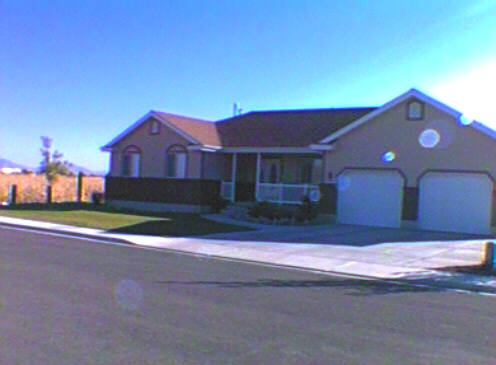
 Total Photos: 2
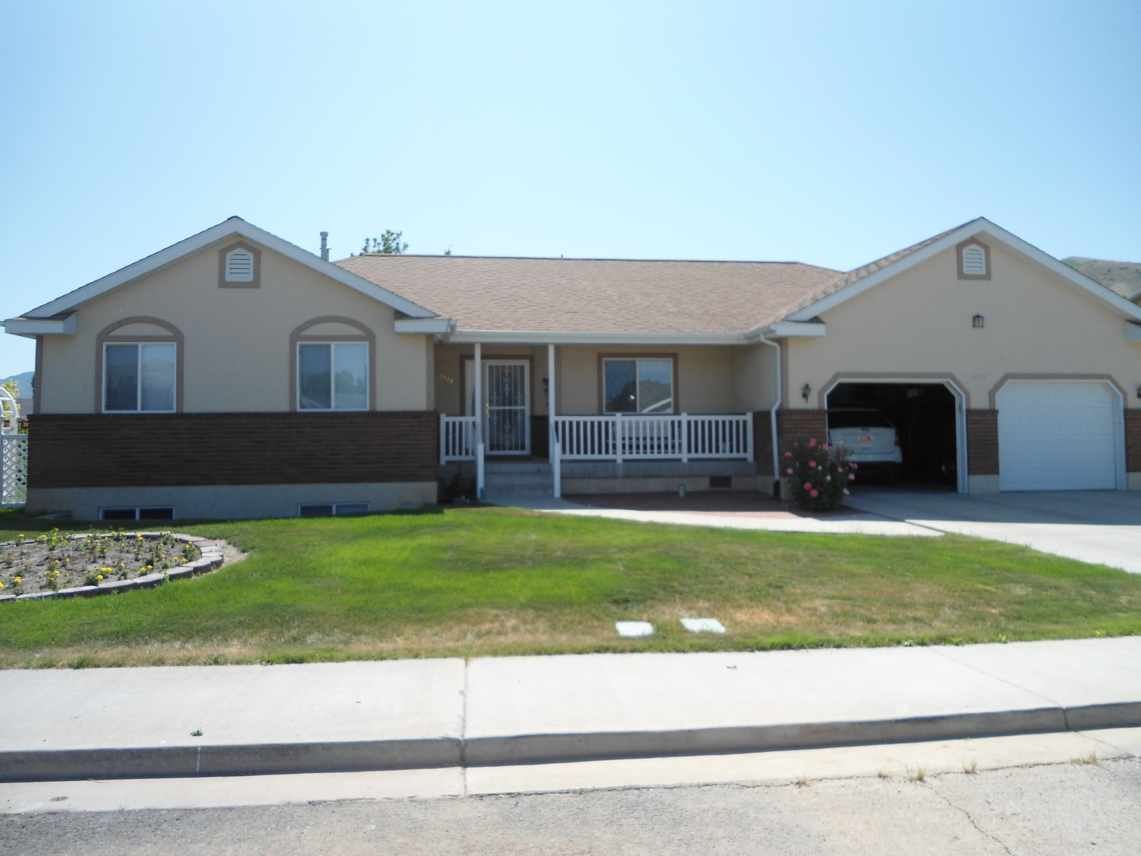
|
| |
|
|
| Property Address: 1423 S 500 WEST - PAYSON |
|
| Mailing Address: 1423 S 500 W PAYSON, UT 84651-8610 |
|
| Acreage: 0.229 |
|
| Last Document:
4117-1995
|
|
| Subdivision Map Filing |
|
| Taxing Description:
LOT 14, PLAT A, DRY CREEK SUBDV. AREA 0.229 AC.
*Taxing description NOT FOR LEGAL DOCUMENTS
|
|
- Owner Names
- Value History
- Tax History
- Location
- Photos
- Documents
- Aerial Image
| 2020... |
|
HINDES, JASON A |
|
| 2020... |
|
HINDES, KAMI S |
|
| 2020NV |
|
AMD & RESTATED DEONNA L VAN NOSDAL TRUST 08-29-2017 THE |
|
| 2020NV |
|
GEORGE B AND DEONNA L VAN NOSDOL FAMILY TRUST 11-27-2012 |
|
| 2020NV |
|
VAN NOSDOL, GEORGE LESTER |
|
| 2014-2019 |
|
VAN NOSDOL, DEONNA L |
|
| 2014-2019 |
|
VAN NOSDOL, GEORGE B |
|
| 2001-2013 |
|
VAN NOSDOL, DEONNA L |
|
| 2001-2013 |
|
VAN NOSDOL, GEORGE B |
|
| 1997-2000 |
|
VAN NOSDOL, DEONNA L |
|
| 1997-2000 |
|
VAN NOSDOL, GEORGE B |
|
| 1997NV |
|
VAN NOSDOL, DEONNA L |
|
| 1997NV |
|
VAN NOSDOL, GEORGE B |
|
| 1996 |
|
VAN NOSDOL, DEONNA L |
|
| 1996 |
|
VAN NOSDOL, GEORGE B |
|
| 1996NV |
|
COOK, GLENN F |
|
| |
----- Real Estate Values ----- |
---Improvements--- |
---Greenbelt--- |
Total |
| Year |
Com |
Res |
Agr |
Tot |
Com |
Res |
Agr |
Tot |
Land |
Homesite |
Tot |
Market Value |
| 2024 |
$0 |
$151,400 |
$0 |
$151,400 |
$0 |
$360,300 |
$0 |
$360,300 |
$0 |
$0 |
$0 |
$511,700 |
| 2023 |
$0 |
$151,400 |
$0 |
$151,400 |
$0 |
$368,000 |
$0 |
$368,000 |
$0 |
$0 |
$0 |
$519,400 |
| 2022 |
$0 |
$161,400 |
$0 |
$161,400 |
$0 |
$334,200 |
$0 |
$334,200 |
$0 |
$0 |
$0 |
$495,600 |
| 2021 |
$0 |
$115,300 |
$0 |
$115,300 |
$0 |
$255,100 |
$0 |
$255,100 |
$0 |
$0 |
$0 |
$370,400 |
| 2020 |
$0 |
$104,800 |
$0 |
$104,800 |
$0 |
$238,900 |
$0 |
$238,900 |
$0 |
$0 |
$0 |
$343,700 |
| 2019 |
$0 |
$86,800 |
$0 |
$86,800 |
$0 |
$238,900 |
$0 |
$238,900 |
$0 |
$0 |
$0 |
$325,700 |
| 2018 |
$0 |
$75,900 |
$0 |
$75,900 |
$0 |
$207,700 |
$0 |
$207,700 |
$0 |
$0 |
$0 |
$283,600 |
| 2017 |
$0 |
$68,700 |
$0 |
$68,700 |
$0 |
$194,500 |
$0 |
$194,500 |
$0 |
$0 |
$0 |
$263,200 |
| 2016 |
$0 |
$61,500 |
$0 |
$61,500 |
$0 |
$193,800 |
$0 |
$193,800 |
$0 |
$0 |
$0 |
$255,300 |
| 2015 |
$0 |
$54,200 |
$0 |
$54,200 |
$0 |
$185,500 |
$0 |
$185,500 |
$0 |
$0 |
$0 |
$239,700 |
| 2014 |
$0 |
$50,600 |
$0 |
$50,600 |
$0 |
$172,200 |
$0 |
$172,200 |
$0 |
$0 |
$0 |
$222,800 |
| 2013 |
$0 |
$43,200 |
$0 |
$43,200 |
$0 |
$152,600 |
$0 |
$152,600 |
$0 |
$0 |
$0 |
$195,800 |
| 2012 |
$0 |
$46,600 |
$0 |
$46,600 |
$0 |
$167,400 |
$0 |
$167,400 |
$0 |
$0 |
$0 |
$214,000 |
| 2011 |
$0 |
$37,300 |
$0 |
$37,300 |
$0 |
$189,200 |
$0 |
$189,200 |
$0 |
$0 |
$0 |
$226,500 |
| 2010 |
$0 |
$55,300 |
$0 |
$55,300 |
$0 |
$185,469 |
$0 |
$185,469 |
$0 |
$0 |
$0 |
$240,769 |
| 2009 |
$0 |
$55,300 |
$0 |
$55,300 |
$0 |
$201,800 |
$0 |
$201,800 |
$0 |
$0 |
$0 |
$257,100 |
| 2008 |
$0 |
$55,300 |
$0 |
$55,300 |
$0 |
$201,800 |
$0 |
$201,800 |
$0 |
$0 |
$0 |
$257,100 |
| 2007 |
$0 |
$57,000 |
$0 |
$57,000 |
$0 |
$208,000 |
$0 |
$208,000 |
$0 |
$0 |
$0 |
$265,000 |
| 2006 |
$0 |
$48,300 |
$0 |
$48,300 |
$0 |
$182,100 |
$0 |
$182,100 |
$0 |
$0 |
$0 |
$230,400 |
| 2005 |
$0 |
$46,000 |
$0 |
$46,000 |
$0 |
$173,434 |
$0 |
$173,434 |
$0 |
$0 |
$0 |
$219,434 |
| 2004 |
$0 |
$46,000 |
$0 |
$46,000 |
$0 |
$173,434 |
$0 |
$173,434 |
$0 |
$0 |
$0 |
$219,434 |
| 2003 |
$0 |
$46,000 |
$0 |
$46,000 |
$0 |
$173,434 |
$0 |
$173,434 |
$0 |
$0 |
$0 |
$219,434 |
| 2002 |
$0 |
$30,679 |
$0 |
$30,679 |
$0 |
$173,434 |
$0 |
$173,434 |
$0 |
$0 |
$0 |
$204,113 |
| 2001 |
$0 |
$35,263 |
$0 |
$35,263 |
$0 |
$157,667 |
$0 |
$157,667 |
$0 |
$0 |
$0 |
$192,930 |
| 2000 |
$0 |
$32,956 |
$0 |
$32,956 |
$0 |
$143,451 |
$0 |
$143,451 |
$0 |
$0 |
$0 |
$176,407 |
| 1999 |
$0 |
$32,956 |
$0 |
$32,956 |
$0 |
$117,810 |
$0 |
$117,810 |
$0 |
$0 |
$0 |
$150,766 |
| 1998 |
$0 |
$32,956 |
$0 |
$32,956 |
$0 |
$117,810 |
$0 |
$117,810 |
$0 |
$0 |
$0 |
$150,766 |
| 1997 |
$0 |
$32,956 |
$0 |
$32,956 |
$0 |
$117,810 |
$0 |
$117,810 |
$0 |
$0 |
$0 |
$150,766 |
| 1996 |
$0 |
$32,450 |
$0 |
$32,450 |
$0 |
$116,000 |
$0 |
$116,000 |
$0 |
$0 |
$0 |
$148,450 |
| Year |
General Taxes |
Adjustments |
Net Taxes |
Fees |
Payments |
Tax Balance* |
Balance Due |
Tax District |
| 2025 |
$0.00 |
$0.00 |
$0.00 |
$0.00 |
|
$0.00
|
$0.00 |
170 - PAYSON CITY |
| 2024 |
$2,765.38 |
$0.00 |
$2,765.38 |
$0.00 |
|
$0.00
|
$0.00 |
170 - PAYSON CITY |
| 2023 |
$2,799.28 |
$0.00 |
$2,799.28 |
$0.00 |
|
$0.00
|
$0.00 |
170 - PAYSON CITY |
| 2022 |
$2,715.71 |
$0.00 |
$2,715.71 |
$0.00 |
|
$0.00
|
$0.00 |
170 - PAYSON CITY |
| 2021 |
$2,300.81 |
$0.00 |
$2,300.81 |
$0.00 |
|
$0.00
|
$0.00 |
170 - PAYSON CITY |
| 2020 |
$2,182.22 |
$0.00 |
$2,182.22 |
$0.00 |
|
$0.00
|
$0.00 |
170 - PAYSON CITY |
| 2019 |
$2,017.06 |
$0.00 |
$2,017.06 |
$0.00 |
|
$0.00
|
$0.00 |
170 - PAYSON CITY |
| 2018 |
$1,822.31 |
$0.00 |
$1,822.31 |
$0.00 |
|
$0.00
|
$0.00 |
170 - PAYSON CITY |
| 2017 |
$1,729.45 |
$0.00 |
$1,729.45 |
$0.00 |
|
$0.00
|
$0.00 |
170 - PAYSON CITY |
| 2016 |
$1,688.63 |
$0.00 |
$1,688.63 |
$0.00 |
|
$0.00
|
$0.00 |
170 - PAYSON CITY |
| 2015 |
$1,596.39 |
$0.00 |
$1,596.39 |
$0.00 |
|
$0.00
|
$0.00 |
170 - PAYSON CITY |
| 2014 |
$1,473.18 |
$0.00 |
$1,473.18 |
$0.00 |
|
$0.00
|
$0.00 |
170 - PAYSON CITY |
| 2013 |
$1,355.17 |
$0.00 |
$1,355.17 |
$0.00 |
|
$0.00
|
$0.00 |
170 - PAYSON CITY |
| 2012 |
$1,503.50 |
$0.00 |
$1,503.50 |
$0.00 |
|
$0.00
|
$0.00 |
170 - PAYSON CITY |
| 2011 |
$1,553.57 |
$0.00 |
$1,553.57 |
$0.00 |
|
$0.00
|
$0.00 |
170 - PAYSON CITY |
| 2010 |
$1,610.26 |
$0.00 |
$1,610.26 |
$0.00 |
|
$0.00
|
$0.00 |
170 - PAYSON CITY |
| 2009 |
$1,628.56 |
$0.00 |
$1,628.56 |
$0.00 |
|
$0.00
|
$0.00 |
170 - PAYSON CITY |
| 2008 |
$1,514.87 |
$0.00 |
$1,514.87 |
$0.00 |
|
$0.00
|
$0.00 |
170 - PAYSON CITY |
| 2007 |
$1,548.74 |
$0.00 |
$1,548.74 |
$0.00 |
|
$0.00
|
$0.00 |
170 - PAYSON CITY |
| 2006 |
$1,496.18 |
$0.00 |
$1,496.18 |
$0.00 |
|
$0.00
|
$0.00 |
170 - PAYSON CITY |
| 2005 |
$1,516.94 |
$0.00 |
$1,516.94 |
$0.00 |
|
$0.00
|
$0.00 |
170 - PAYSON CITY |
| 2004 |
$1,521.16 |
$0.00 |
$1,521.16 |
$0.00 |
|
$0.00
|
$0.00 |
170 - PAYSON CITY |
| 2003 |
$1,380.68 |
$0.00 |
$1,380.68 |
$0.00 |
|
$0.00
|
$0.00 |
170 - PAYSON CITY |
| 2002 |
$1,253.52 |
$0.00 |
$1,253.52 |
$0.00 |
|
$0.00
|
$0.00 |
170 - PAYSON CITY |
| 2001 |
$1,206.81 |
$0.00 |
$1,206.81 |
$0.00 |
|
$0.00
|
$0.00 |
170 - PAYSON CITY |
| 2000 |
$1,091.62 |
$0.00 |
$1,091.62 |
$0.00 |
|
$0.00
|
$0.00 |
170 - PAYSON CITY |
| 1999 |
$885.69 |
$0.00 |
$885.69 |
$0.00 |
|
$0.00
|
$0.00 |
170 - PAYSON CITY |
| 1998 |
$863.80 |
$0.00 |
$863.80 |
$0.00 |
|
$0.00
|
$0.00 |
170 - PAYSON CITY |
| 1997 |
$952.77 |
$0.00 |
$952.77 |
$0.00 |
|
$0.00
|
$0.00 |
170 - PAYSON CITY |
| 1996 |
$924.17 |
$0.00 |
$924.17 |
$0.00 |
|
$0.00
|
$0.00 |
170 - PAYSON CITY |
* Note: Original tax amount (Does not include applicable interest and/or fees).
| Entry # |
Date |
Recorded |
Type |
Party1 (Grantor) |
Party2 (Grantee) |
| 148315-2020 |
09/24/2020 |
09/28/2020 |
REC |
FIRST AMERICAN TITLE INSURANCE COMPANY TEE |
HINDES, KAMI S & JASON A |
| 148314-2020 |
09/24/2020 |
09/28/2020 |
SUB TEE |
MORTGAGE ELECTRONIC REGISTRATION SYSTEMS INC |
FIRST AMERICAN TITLE INSURANCE COMPANY SUBTEE |
| 112422-2020 |
07/28/2020 |
08/03/2020 |
D TR |
HINDES, KAMI S & JASON A |
QUICKEN LOANS LLC |
| 126219-2019 |
11/27/2019 |
11/27/2019 |
D TR |
HINDES, KAMI S & JASON A |
QUICKEN LOANS INC |
| 126200-2019 |
11/26/2019 |
11/27/2019 |
WD |
VAN NOSDOL, GEORGE LESTER TEE (ET AL) |
HINDES, KAMI S & JASON A |
| 126199-2019 |
11/26/2019 |
11/27/2019 |
AF DC |
VAN NOSDOL, GEORGE BURLEY & GEORGE B AKA (ET AL) |
VAN NOSDOL, GEORGE LESTER TEE (ET AL) |
| 3187-2015 |
12/04/2014 |
01/14/2015 |
QCD |
UNITED STATES OF AMERICA |
SOUTH UTAH VALLEY ELECTRIC SERVICE DISTRICT |
| 32290-2013 |
11/12/2012 |
04/02/2013 |
QCD |
VAN NOSDOL, GEORGE B & DEONNA L |
VAN NOSDOL, GEORGE B & DEONNA L TEE |
| 114949-2008 |
10/20/2008 |
10/22/2008 |
CT |
STATE OF UTAH |
WHOM OF INTEREST |
| 107508-2008 |
09/30/2008 |
09/30/2008 |
RESOL |
BOARD OF COUNTY COMMISSIONERS UTAH COUNTY |
WHOM OF INTEREST |
| 13253-2006 |
01/11/2006 |
02/02/2006 |
RSUBTEE |
MORTGAGE ELECTRONIC REGISTRATION SYSTEMS INC (ET AL) |
BROWN, MINDY |
| 80116-2002 |
04/24/2002 |
07/17/2002 |
REC |
WELLS FARGO FINANCIAL NATIONAL BANK SUCTEE |
VANNOSDOL, GEORGE B & DEONNA L |
| 80115-2002 |
04/24/2002 |
07/17/2002 |
SUB TEE |
MORTGAGE ELECTRONIC REGISTRATION SYSTEMS INC |
WELLS FARGO FINANCIAL NATIONAL BANK SUCTEE |
| 32386-2001 |
04/03/2001 |
04/06/2001 |
AF |
PAYSON CITY |
WHOM OF INTEREST |
| 15427-2001 |
01/31/2001 |
02/22/2001 |
AS |
FIRST SECURITY BANK |
MORTGAGE ELECTRONIC REGISTRATION SYSTEMS INC |
| 51779-1997 |
05/17/1996 |
07/08/1997 |
WATER D |
VAN NOSDOL, GEORGE B & DEONNA L |
STRAWBERRY HIGH LINE CANAL COMPANY |
| 63368-1996 |
08/01/1996 |
08/02/1996 |
REC |
CENTRAL BANK AND TRUST COMPANY TEE |
COOK, GLENN F |
| 54725-1996 |
09/05/1995 |
07/02/1996 |
REC |
OLD REPUBLIC TITLE OF UTAH TEE |
VAN NOSDOL, GOERGE B & DEONNA L |
| 85161-1995 |
12/07/1995 |
12/08/1995 |
D TR |
VAN NOSDOL, GEORGE B & DEONNA L |
FIRST SECURITY BANK OF UTAH |
| 79565-1995 |
11/17/1995 |
11/17/1995 |
REC |
OLD REPUBLIC TITLE OF UTAH TEE |
COOK, GLENN F |
| 79564-1995 |
11/16/1995 |
11/17/1995 |
REC |
CENTRAL BANK & TRUST COMPANY TEE |
COOK, GLENN F |
| 58919-1995 |
08/31/1995 |
09/06/1995 |
D TR |
VAN NOSDOL, GEORGE B & DEONNA L |
FIRST SECURITY BANK OF UTAH |
| 28462-1995 |
05/02/1995 |
05/08/1995 |
P REC |
CENTRAL BANK & TRUST COMPANY TEE |
COOK, GLENN F |
| 21373-1995 |
04/06/1995 |
04/07/1995 |
P REC |
OLD REPUBLIC TITLE OF UTAH TEE |
COOK, GLENN F |
| 21082-1995 |
03/31/1995 |
04/06/1995 |
WD |
COOK, GLENN F |
VAN NOSDOL, GEORGE B & DEONNA L |
| 18228-1995 |
03/16/1995 |
03/24/1995 |
RES COV |
COOK, GLENN F |
WHOM OF INTEREST |
| 5027-1995 |
01/23/1995 |
01/25/1995 |
SUB AGR |
ROGERS, THOMAS G & MARK F |
CENTRAL BANK |
| 5026-1995 |
01/20/1995 |
01/25/1995 |
D TR |
COOK, GLENN F |
CENTRAL BANK |
| 4117-1995 |
01/04/1995 |
01/20/1995 |
S PLAT |
COOK, GLENN F |
DRY CREEK PLAT A |
Main Menu Comments or Concerns on Value/Appraisal - Assessor's Office
Documents/Owner/Parcel information - Recorder's Office
Address Change for Tax Notice
This page was created on 4/22/2025 3:13:03 PM |