Property Information
mobile view
| Serial Number: 37:228:0002 |
Serial Life: 2006... |
|
|
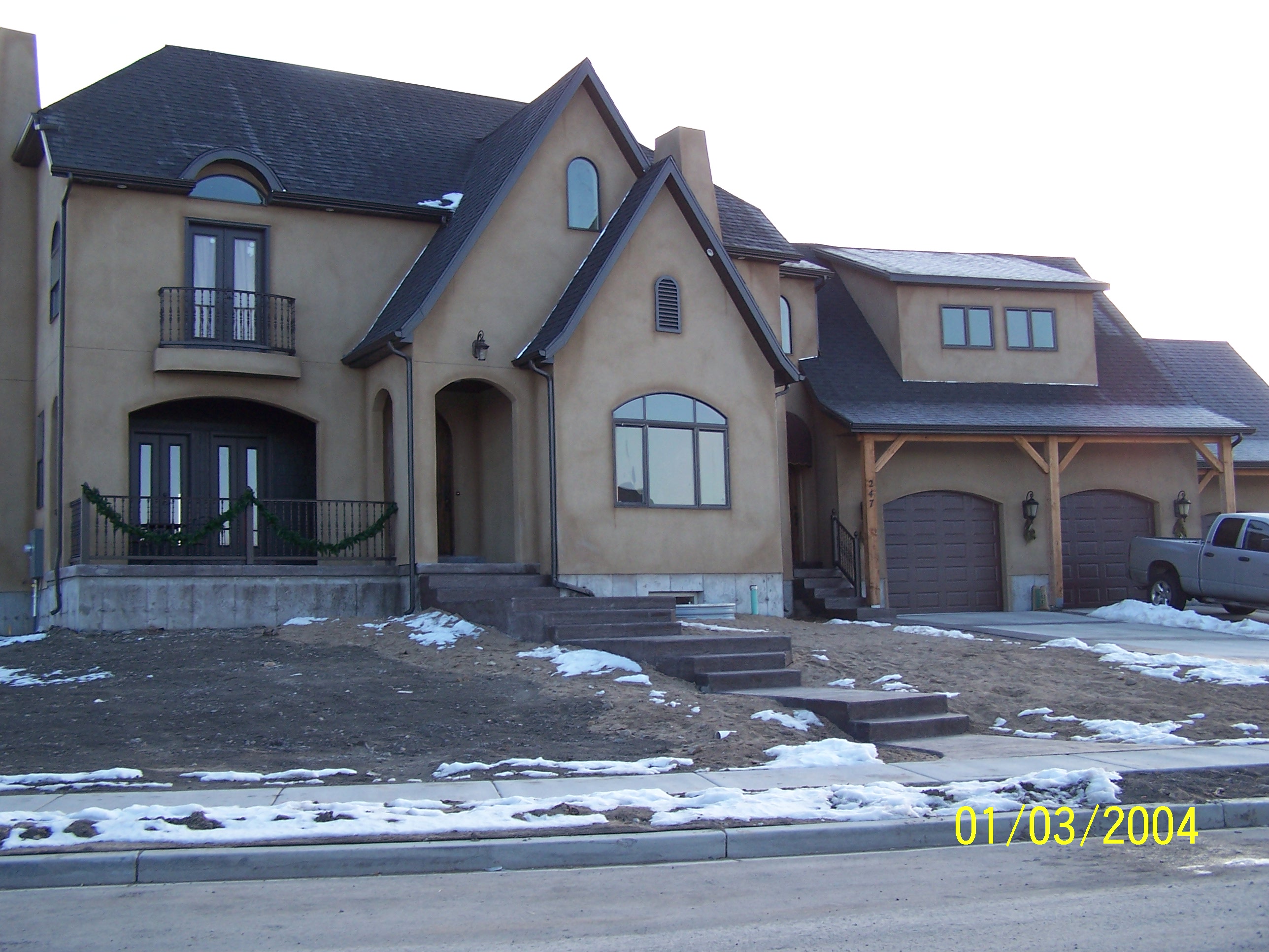 Total Photos: 2
|
| |
|
|
| Property Address: 247 S 650 WEST CIR - AMERICAN FORK |
|
| Mailing Address: 247 S 650 W CIR AMERICAN FORK, UT 84003-5609 |
|
| Acreage: 0.348 |
|
| Last Document:
55235-2005
|
|
| Subdivision Map Filing |
|
| Taxing Description:
LOT 2, DURRANT MEADOWS SUBDV. AREA 0.348 AC.
*Taxing description NOT FOR LEGAL DOCUMENTS
|
|
- Owner Names
- Value History
- Tax History
- Location
- Photos
- Documents
- Aerial Image
| |
----- Real Estate Values ----- |
---Improvements--- |
---Greenbelt--- |
Total |
| Year |
Com |
Res |
Agr |
Tot |
Com |
Res |
Agr |
Tot |
Land |
Homesite |
Tot |
Market Value |
| 2025 |
$0 |
$232,200 |
$0 |
$232,200 |
$0 |
$557,400 |
$0 |
$557,400 |
$0 |
$0 |
$0 |
$789,600 |
| 2024 |
$0 |
$221,100 |
$0 |
$221,100 |
$0 |
$484,300 |
$0 |
$484,300 |
$0 |
$0 |
$0 |
$705,400 |
| 2023 |
$0 |
$201,000 |
$0 |
$201,000 |
$0 |
$510,800 |
$0 |
$510,800 |
$0 |
$0 |
$0 |
$711,800 |
| 2022 |
$0 |
$211,400 |
$0 |
$211,400 |
$0 |
$601,700 |
$0 |
$601,700 |
$0 |
$0 |
$0 |
$813,100 |
| 2021 |
$0 |
$162,600 |
$0 |
$162,600 |
$0 |
$449,000 |
$0 |
$449,000 |
$0 |
$0 |
$0 |
$611,600 |
| 2020 |
$0 |
$150,600 |
$0 |
$150,600 |
$0 |
$427,600 |
$0 |
$427,600 |
$0 |
$0 |
$0 |
$578,200 |
| 2019 |
$0 |
$150,600 |
$0 |
$150,600 |
$0 |
$424,400 |
$0 |
$424,400 |
$0 |
$0 |
$0 |
$575,000 |
| 2018 |
$0 |
$142,700 |
$0 |
$142,700 |
$0 |
$436,200 |
$0 |
$436,200 |
$0 |
$0 |
$0 |
$578,900 |
| 2017 |
$0 |
$142,700 |
$0 |
$142,700 |
$0 |
$436,200 |
$0 |
$436,200 |
$0 |
$0 |
$0 |
$578,900 |
| 2016 |
$0 |
$87,200 |
$0 |
$87,200 |
$0 |
$379,300 |
$0 |
$379,300 |
$0 |
$0 |
$0 |
$466,500 |
| 2015 |
$0 |
$79,300 |
$0 |
$79,300 |
$0 |
$329,800 |
$0 |
$329,800 |
$0 |
$0 |
$0 |
$409,100 |
| 2014 |
$0 |
$75,300 |
$0 |
$75,300 |
$0 |
$319,700 |
$0 |
$319,700 |
$0 |
$0 |
$0 |
$395,000 |
| 2013 |
$0 |
$69,200 |
$0 |
$69,200 |
$0 |
$286,800 |
$0 |
$286,800 |
$0 |
$0 |
$0 |
$356,000 |
| 2012 |
$0 |
$60,000 |
$0 |
$60,000 |
$0 |
$318,700 |
$0 |
$318,700 |
$0 |
$0 |
$0 |
$378,700 |
| 2011 |
$0 |
$60,000 |
$0 |
$60,000 |
$0 |
$330,400 |
$0 |
$330,400 |
$0 |
$0 |
$0 |
$390,400 |
| 2010 |
$0 |
$62,414 |
$0 |
$62,414 |
$0 |
$335,995 |
$0 |
$335,995 |
$0 |
$0 |
$0 |
$398,409 |
| 2009 |
$0 |
$91,200 |
$0 |
$91,200 |
$0 |
$333,100 |
$0 |
$333,100 |
$0 |
$0 |
$0 |
$424,300 |
| 2008 |
$0 |
$124,900 |
$0 |
$124,900 |
$0 |
$358,636 |
$0 |
$358,636 |
$0 |
$0 |
$0 |
$483,536 |
| 2007 |
$0 |
$131,500 |
$0 |
$131,500 |
$0 |
$436,400 |
$0 |
$436,400 |
$0 |
$0 |
$0 |
$567,900 |
| 2006 |
$0 |
$110,000 |
$0 |
$110,000 |
$0 |
$0 |
$0 |
$0 |
$0 |
$0 |
$0 |
$110,000 |
| Year |
General Taxes |
Adjustments |
Net Taxes |
Fees |
Payments |
Tax Balance* |
Balance Due |
Tax Area |
| 2026 |
$0.00 |
$0.00 |
$0.00 |
$0.00 |
|
$0.00
|
$0.00 |
060 - AMERICAN FORK CITY |
| 2025 |
$0.00 |
$0.00 |
$0.00 |
$0.00 |
|
$0.00
|
$0.00 |
060 - AMERICAN FORK CITY |
| 2024 |
$3,491.73 |
$0.00 |
$3,491.73 |
$0.00 |
|
$0.00
|
$0.00 |
060 - AMERICAN FORK CITY |
| 2023 |
$3,323.36 |
$0.00 |
$3,323.36 |
$0.00 |
|
$0.00
|
$0.00 |
060 - AMERICAN FORK CITY |
| 2022 |
$3,846.86 |
$0.00 |
$3,846.86 |
$0.00 |
|
$0.00
|
$0.00 |
060 - AMERICAN FORK CITY |
| 2021 |
$3,368.17 |
$0.00 |
$3,368.17 |
$0.00 |
|
$0.00
|
$0.00 |
060 - AMERICAN FORK CITY |
| 2020 |
$3,283.14 |
$0.00 |
$3,283.14 |
$0.00 |
|
$0.00
|
$0.00 |
060 - AMERICAN FORK CITY |
| 2019 |
$3,480.17 |
($323.36) |
$3,156.81 |
$0.00 |
|
$0.00
|
$0.00 |
060 - AMERICAN FORK CITY |
| 2018 |
$3,324.04 |
$0.00 |
$3,324.04 |
$0.00 |
|
$0.00
|
$0.00 |
060 - AMERICAN FORK CITY |
| 2017 |
$3,387.40 |
$0.00 |
$3,387.40 |
$0.00 |
|
$0.00
|
$0.00 |
060 - AMERICAN FORK CITY |
| 2016 |
$2,938.04 |
$0.00 |
$2,938.04 |
$0.00 |
|
$0.00
|
$0.00 |
060 - AMERICAN FORK CITY |
| 2015 |
$2,714.91 |
$0.00 |
$2,714.91 |
$0.00 |
|
$0.00
|
$0.00 |
060 - AMERICAN FORK CITY |
| 2014 |
$2,725.35 |
($67.95) |
$2,657.40 |
$0.00 |
|
$0.00
|
$0.00 |
060 - AMERICAN FORK CITY |
| 2013 |
$2,581.04 |
$0.00 |
$2,581.04 |
$0.00 |
|
$0.00
|
$0.00 |
060 - AMERICAN FORK CITY |
| 2012 |
$2,801.02 |
$0.00 |
$2,801.02 |
$0.00 |
|
$0.00
|
$0.00 |
060 - AMERICAN FORK CITY |
| 2011 |
$2,879.82 |
$0.00 |
$2,879.82 |
$0.00 |
|
$0.00
|
$0.00 |
060 - AMERICAN FORK CITY |
| 2010 |
$2,759.00 |
$0.00 |
$2,759.00 |
$0.00 |
|
$0.00
|
$0.00 |
060 - AMERICAN FORK CITY |
| 2009 |
$2,704.93 |
$0.00 |
$2,704.93 |
$0.00 |
|
$0.00
|
$0.00 |
060 - AMERICAN FORK CITY |
| 2008 |
$2,897.74 |
$0.00 |
$2,897.74 |
$0.00 |
|
$0.00
|
$0.00 |
060 - AMERICAN FORK CITY |
| 2007 |
$3,271.50 |
$0.00 |
$3,271.50 |
$0.00 |
|
$0.00
|
$0.00 |
060 - AMERICAN FORK CITY |
| 2006 |
$1,238.71 |
$0.00 |
$1,238.71 |
$0.00 |
|
$0.00
|
$0.00 |
060 - AMERICAN FORK CITY |
* Note: Original tax amount (Does not include applicable interest and/or fees).
| Entry # |
Date |
Recorded |
Type |
Party1 (Grantor) |
Party2 (Grantee) |
| 10301-2021 |
01/04/2021 |
01/20/2021 |
REC |
FIRST AMERICAN TITLE INSURANCE COMPANY TEE |
MILLER, SCOTT & LIBERTY |
| 10300-2021 |
01/04/2021 |
01/20/2021 |
SUB TEE |
NEW RESIDENDIAL MORTGAGE LLC BY ATY |
FIRST AMERICAN TITLE INSURANCE COMPANY SUBTEE |
| 195287-2020 |
12/03/2020 |
12/08/2020 |
WD |
MILLER, SCOTT |
MILLER, SCOTT & LIBERTY |
| 195286-2020 |
12/03/2020 |
12/08/2020 |
D TR |
MILLER, SCOTT |
FIRST COLONY MORTGAGE CORPORATION |
| 195285-2020 |
12/03/2020 |
12/08/2020 |
WD |
MILLER, SCOTT & LIBERTY |
MILLER, SCOTT |
| 34200-2020 |
03/17/2020 |
03/18/2020 |
AS |
DITECH FINANCIAL LLC |
NEW RESIDENTAL MORTGAGE LLC |
| 27817-2019 |
03/12/2019 |
04/04/2019 |
MOD AGR |
MILLER, SCOTT & LIBERTY |
DITECH FINANCIAL LLC |
| 43097-2018 |
05/03/2018 |
05/09/2018 |
REC |
FIRST AMERICAN TITLE INSURANCE COMPANY TEE |
MILLER, SCOTT & LIBERTY |
| 43096-2018 |
04/26/2018 |
05/09/2018 |
SUB TEE |
PNC BANK |
FIRST AMERICAN TITLE INSURANCE COMPANY SUCTEE |
| 44925-2014 |
06/20/2014 |
07/01/2014 |
AS |
CITIMORTGAGE INC |
GREEN TREE SERVICING LLC |
| 53030-2011 |
07/26/2011 |
07/27/2011 |
CAN ND |
HALLIDAY, PAUL M JR SUCTEE |
MILLER, LIBERTY & SCOTT |
| 53029-2011 |
07/26/2011 |
07/27/2011 |
CAN ND |
HALLIDAY, PAUL M JR SUCTEE |
MILLER, LIBERTY & SCOTT |
| 104872-2010 |
11/29/2010 |
12/02/2010 |
SUB TEE |
CITI MORTGAGE INC |
HALLIDAY, PAUL M JR SUCTEE |
| 100300-2010 |
11/17/2010 |
11/17/2010 |
ND |
HALLIDAY, PAUL M JR SUCTEE |
MILLER, LIBERTY & SCOTT |
| 100299-2010 |
11/12/2010 |
11/17/2010 |
AS |
MORTGAGE ELECTRONIC REGISTRATION SYSTEMS INC |
CITIMORTGAGE INC |
| 114949-2008 |
10/20/2008 |
10/22/2008 |
CT |
STATE OF UTAH |
WHOM OF INTEREST |
| 107508-2008 |
09/30/2008 |
09/30/2008 |
RESOL |
BOARD OF COUNTY COMMISSIONERS UTAH COUNTY |
WHOM OF INTEREST |
| 82696-2007 |
05/24/2007 |
06/05/2007 |
REC |
FIDELITY NATIONAL TITLE INSURANCE COMPANY TEE |
MILLER, SCOTT & LIBERTY |
| 82695-2007 |
05/16/2007 |
06/05/2007 |
SUB TEE |
MORTGAGE ELECTRONIC REGISTRATION SYSTEMS INC |
FIDELITY NATIONAL TITLE INSURANCE COMPANY SUCTEE |
| 65746-2007 |
04/27/2007 |
05/03/2007 |
REC |
RICHARDS, BRUCE L TEE |
MILLER, SCOTT & LIBERTY |
| 65745-2007 |
12/19/2006 |
05/03/2007 |
RSUBTEE |
SALT LAKE CREDIT UNION (ET AL) |
MILLER, SCOTT & LIBERTY |
| 59125-2007 |
04/17/2007 |
04/23/2007 |
D TR |
MILLER, SCOTT & LIBERTY |
NATIONAL CITY BANK |
| 59124-2007 |
04/17/2007 |
04/23/2007 |
D TR |
MILLER, SCOTT & LIBERTY |
SECURITY HOME MORTGAGE LLC |
| 169909-2006 |
12/13/2006 |
12/18/2006 |
R LN |
SUNROC CORPORATION |
WHOM OF INTEREST |
| 166881-2006 |
11/22/2006 |
12/12/2006 |
R LN |
SUNROC CORPORATION |
WHOM OF INTEREST |
| 158902-2006 |
11/21/2006 |
11/27/2006 |
D TR |
MILLER, SCOTT & LIBERTY |
SECURITY HOME MORTGAGE LLC |
| 130045-2006 |
09/29/2006 |
10/02/2006 |
N LN |
MILLER, SCOTT & LIBERTY |
SUNROC CORPORATION |
| 36912-2006 |
03/15/2006 |
03/28/2006 |
REC |
WESTERN COMMUNITY BANK TEE |
HEYMAN, WALTER A |
| 22940-2006 |
02/21/2006 |
02/27/2006 |
SUP TRD |
MILLER, SCOTT & LIBERTY |
FIRST AMERICAN TITLE INSURANCE COMPANY |
| 11173-2006 |
01/30/2006 |
01/30/2006 |
W FARM |
CARTER, CHAD & STACIE (ET AL) |
WHOM OF INTEREST |
| 146886-2005 |
10/12/2005 |
12/20/2005 |
REC |
WESTERN COMMUNITY BANK TEE |
HEYMAN, WALTER A |
| 79488-2005 |
07/21/2005 |
07/22/2005 |
R FARM |
UTAH COUNTY TREASURER |
FENN, DONALD (ET AL) |
| 78158-2005 |
07/18/2005 |
07/19/2005 |
P REC |
WESTERN COMMUNITY BANK TEE |
HEYMAN, WALTER A |
| 74865-2005 |
06/30/2005 |
07/11/2005 |
AS |
CONSTRUCTION CAPITAL SOURCE |
SALT LAKE CITY CREDIT UNION |
| 72879-2005 |
06/30/2005 |
07/06/2005 |
D TR |
MILLER, SCOTT & LIBERTY |
CONSTRUCTION CAPITAL SOURCE |
| 72878-2005 |
06/30/2005 |
07/06/2005 |
WD |
HEYMAN, WALTER A |
MILLER, SCOTT & LIBERTY |
| 68477-2005 |
06/27/2005 |
06/27/2005 |
W FARM |
UTAH COUNTY |
WHOM OF INTEREST |
| 55235-2005 |
02/08/2005 |
05/24/2005 |
S PLAT |
HEYMAN, WALTER A |
DURRANT MEADOWS |
Main Menu Comments or Concerns on Value/Appraisal - Assessor's Office
Documents/Owner/Parcel information - Recorder's Office
Address Change for Tax Notice
This page was created on 8/2/2025 6:36:14 PM |
