Property Information
mobile view
| Serial Number: 39:237:0002 |
Serial Life: 2016... |
|
|
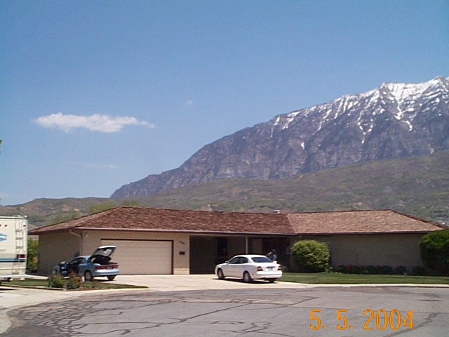 Total Photos: 1
|
| |
|
|
| Property Address: 1065 E 260 SOUTH - OREM |
|
| Mailing Address: 1079 E RIVERSIDE DR # 201 SAINT GEORGE, UT 84790 |
|
| Acreage: 0.398648 |
|
| Last Document:
31609-2023
|
|
| Subdivision Map Filing |
|
| Taxing Description:
LOT 2, PLAT B, FORD SUB AREA 0.399 AC.
*Taxing description NOT FOR LEGAL DOCUMENTS
|
|
- Owner Names
- Value History
- Tax History
- Location
- Photos
- Documents
- Aerial Image
| |
----- Real Estate Values ----- |
---Improvements--- |
---Greenbelt--- |
Total |
| Year |
Com |
Res |
Agr |
Tot |
Com |
Res |
Agr |
Tot |
Land |
Homesite |
Tot |
Market Value |
| 2024 |
$0 |
$309,300 |
$0 |
$309,300 |
$0 |
$418,200 |
$0 |
$418,200 |
$0 |
$0 |
$0 |
$727,500 |
| 2023 |
$0 |
$309,300 |
$0 |
$309,300 |
$0 |
$417,500 |
$0 |
$417,500 |
$0 |
$0 |
$0 |
$726,800 |
| 2022 |
$0 |
$329,800 |
$0 |
$329,800 |
$0 |
$383,300 |
$0 |
$383,300 |
$0 |
$0 |
$0 |
$713,100 |
| 2021 |
$0 |
$194,000 |
$0 |
$194,000 |
$0 |
$339,200 |
$0 |
$339,200 |
$0 |
$0 |
$0 |
$533,200 |
| 2020 |
$0 |
$155,200 |
$0 |
$155,200 |
$0 |
$326,200 |
$0 |
$326,200 |
$0 |
$0 |
$0 |
$481,400 |
| 2019 |
$0 |
$142,900 |
$0 |
$142,900 |
$0 |
$324,400 |
$0 |
$324,400 |
$0 |
$0 |
$0 |
$467,300 |
| 2018 |
$0 |
$130,700 |
$0 |
$130,700 |
$0 |
$324,400 |
$0 |
$324,400 |
$0 |
$0 |
$0 |
$455,100 |
| 2017 |
$0 |
$118,400 |
$0 |
$118,400 |
$0 |
$324,400 |
$0 |
$324,400 |
$0 |
$0 |
$0 |
$442,800 |
| 2016 |
$0 |
$83,300 |
$0 |
$83,300 |
$0 |
$288,000 |
$0 |
$288,000 |
$0 |
$0 |
$0 |
$371,300 |
| Year |
General Taxes |
Adjustments |
Net Taxes |
Fees |
Payments |
Tax Balance* |
Balance Due |
Tax District |
| 2025 |
$0.00 |
$0.00 |
$0.00 |
$0.00 |
|
$0.00
|
$0.00 |
090 - OREM CITY |
| 2024 |
$3,272.22 |
$0.00 |
$3,272.22 |
$0.00 |
|
$0.00
|
$0.00 |
090 - OREM CITY |
| 2023 |
$3,041.62 |
$0.00 |
$3,041.62 |
$0.00 |
|
$0.00
|
$0.00 |
090 - OREM CITY |
| 2022 |
$3,080.38 |
$0.00 |
$3,080.38 |
$0.00 |
|
$0.00
|
$0.00 |
090 - OREM CITY |
| 2021 |
$2,764.86 |
$0.00 |
$2,764.86 |
$0.00 |
|
$0.00
|
$0.00 |
090 - OREM CITY |
| 2020 |
$2,539.94 |
$0.00 |
$2,539.94 |
$0.00 |
|
$0.00
|
$0.00 |
090 - OREM CITY |
| 2019 |
$2,370.96 |
$0.00 |
$2,370.96 |
$0.00 |
|
$0.00
|
$0.00 |
090 - OREM CITY |
| 2018 |
$2,416.69 |
$0.00 |
$2,416.69 |
$0.00 |
|
$0.00
|
$0.00 |
090 - OREM CITY |
| 2017 |
$2,414.21 |
$0.00 |
$2,414.21 |
$0.00 |
|
$0.00
|
$0.00 |
090 - OREM CITY |
| 2016 |
$2,195.31 |
$0.00 |
$2,195.31 |
$0.00 |
|
$0.00
|
$0.00 |
090 - OREM CITY |
* Note: Original tax amount (Does not include applicable interest and/or fees).
| Entry # |
Date |
Recorded |
Type |
Party1 (Grantor) |
Party2 (Grantee) |
| 32179-2023 |
05/19/2023 |
05/19/2023 |
TR D |
PALISADE VIEW LLC |
JOYCE L NIXON FAMILY TRUST 12-07-1990 THE |
| 32178-2023 |
05/18/2023 |
05/19/2023 |
WD |
NIXON, ROBERT DEAN SUCTEE (ET AL) |
PALISADE VIEW LLC |
| 31609-2023 |
05/11/2023 |
05/17/2023 |
AF DC |
NIXON, STANLEY REED & JOYCE LAURA DEC (ET AL) |
NIXON, ROBERT DEAN SUCTEE (ET AL) |
| 61487-2015 |
07/08/2015 |
07/10/2015 |
RSUBTEE |
MORTGAGE ELECTRONIC REGISTRATION SYSTEMS INC (ET AL) |
ERICKSON, LAURA T & LOUIS A |
| 42908-2015 |
05/13/2015 |
05/19/2015 |
REC |
WELLS FARGO FINANCIAL NATIONAL BANK TEE |
ERICKSON, LAURA T & LOUIS A |
| 42907-2015 |
05/13/2015 |
05/19/2015 |
SUB TEE |
MORTGAGE ELECTRONIC REGISTRATION SYSTEMS INC |
WELLS FARGO FINANCIAL NATIONAL BANK SUCTEE |
| 24054-2015 |
03/04/2015 |
03/25/2015 |
S PLAT |
NIXON, JOYCE L & JOYCE LAURA JOHNSON AKA (ET AL) |
FORD PLAT B |
Main Menu Comments or Concerns on Value/Appraisal - Assessor's Office
Documents/Owner/Parcel information - Recorder's Office
Address Change for Tax Notice
This page was created on 11/29/2024 11:26:52 AM |