Property Information
mobile view
| Serial Number: 41:068:0002 |
Serial Life: 1981... |
|
|
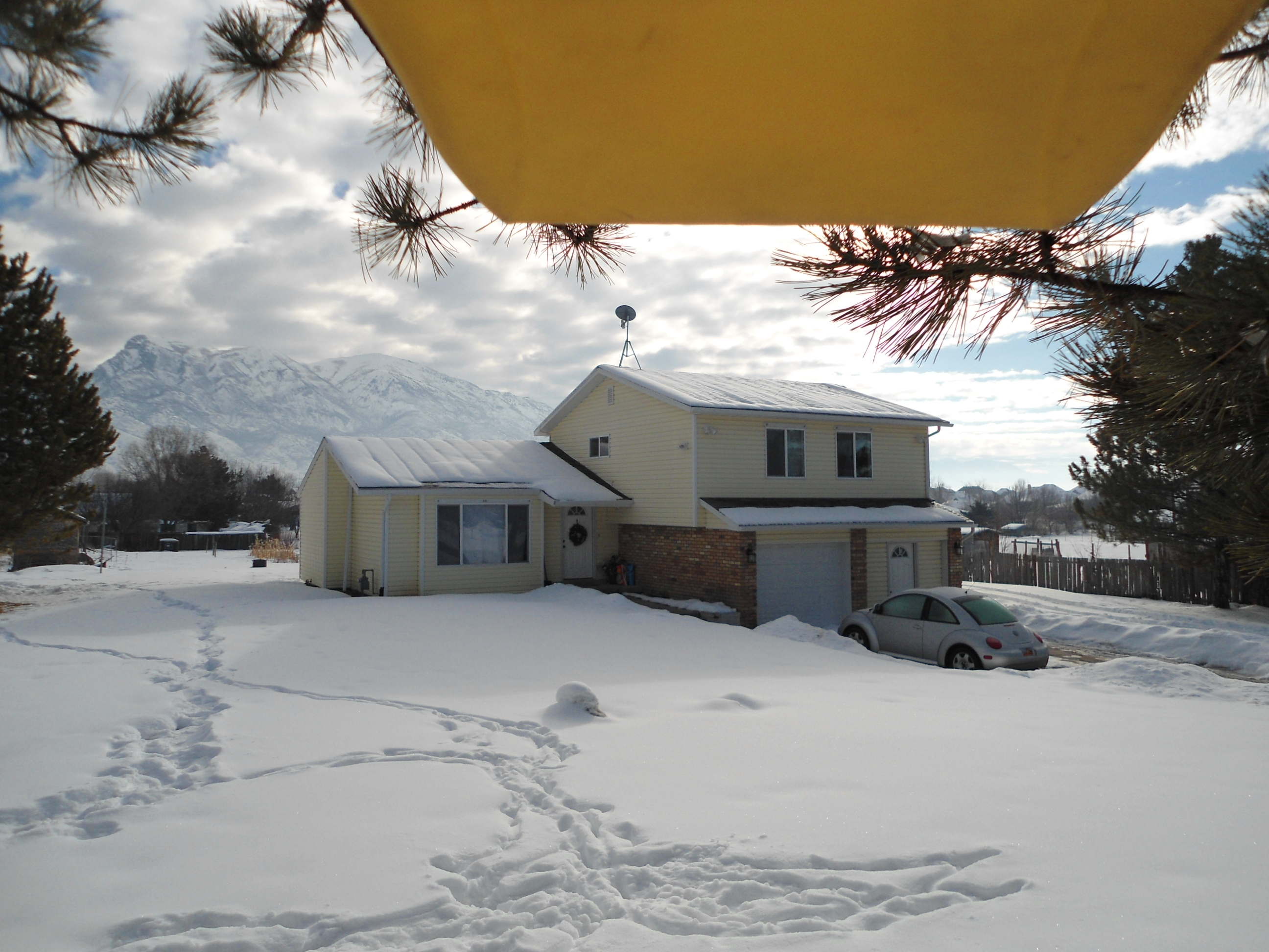 Total Photos: 3
|
| |
|
|
| Property Address: 10848 N 6000 WEST - HIGHLAND |
|
| Mailing Address: 10848 N 6000 W HIGHLAND, UT 84003-9436 |
|
| Acreage: 0.92 |
|
| Last Document:
70084-2008
|
|
| Subdivision Map Filing |
|
| Taxing Description:
LOT 2, PLAT A, HYLAND VIEW SUB AREA 0.924 AC.
*Taxing description NOT FOR LEGAL DOCUMENTS
|
|
- Owner Names
- Value History
- Tax History
- Location
- Photos
- Documents
- Aerial Image
| 2020... |
|
GILLESPIE, PAUL C |
|
| 2020... |
|
GILLESPIE, SHERRY S |
|
| 2014-2019 |
|
GILLESPIE, PAUL C |
|
| 2014-2019 |
|
GILLESPIE, SHERRY S |
|
| 2009-2013 |
|
GILLESPIE, PAUL C |
|
| 2009-2013 |
|
GILLESPIE, SHERRY S |
|
| 2009NV |
|
GILLESPIE, PAUL C |
|
| 2009NV |
|
GILLESPIE, SHERRY S |
|
| 1995-2008 |
|
GILLESPIE, PAUL C |
|
| 1995-2008 |
|
GILLESPIE, SHERRY S |
|
| 1988-1994 |
|
GILLESPIE, PAUL C |
|
| 1988-1994 |
|
GILLESPIE, SHERRY S JT |
|
| 1985-1987 |
|
GILLESPIE, PAUL C |
|
| 1985-1987 |
|
GILLESPIE, SHERRY S JT |
|
| 1983-1984 |
|
GILLISPIE, PAUL C |
|
| 1983-1984 |
|
GILLISPIE, SHERRY S JT |
|
| 1982 |
|
GILLISPIE, PAUL C |
|
| 1982 |
|
GILLISPIE, SHERRY S JT |
|
| 1981 |
|
GILLISPIE, PAUL C |
|
| 1981 |
|
GILLISPIE, SHERRY S JT |
|
| |
----- Real Estate Values ----- |
---Improvements--- |
---Greenbelt--- |
Total |
| Year |
Com |
Res |
Agr |
Tot |
Com |
Res |
Agr |
Tot |
Land |
Homesite |
Tot |
Market Value |
| 2024 |
$0 |
$386,500 |
$0 |
$386,500 |
$0 |
$201,400 |
$0 |
$201,400 |
$0 |
$0 |
$0 |
$587,900 |
| 2023 |
$0 |
$351,400 |
$0 |
$351,400 |
$0 |
$228,800 |
$0 |
$228,800 |
$0 |
$0 |
$0 |
$580,200 |
| 2022 |
$0 |
$368,300 |
$0 |
$368,300 |
$0 |
$241,500 |
$0 |
$241,500 |
$0 |
$0 |
$0 |
$609,800 |
| 2021 |
$0 |
$230,200 |
$0 |
$230,200 |
$0 |
$188,700 |
$0 |
$188,700 |
$0 |
$0 |
$0 |
$418,900 |
| 2020 |
$0 |
$200,200 |
$0 |
$200,200 |
$0 |
$181,400 |
$0 |
$181,400 |
$0 |
$0 |
$0 |
$381,600 |
| 2019 |
$0 |
$199,900 |
$0 |
$199,900 |
$0 |
$165,700 |
$0 |
$165,700 |
$0 |
$0 |
$0 |
$365,600 |
| 2018 |
$0 |
$185,300 |
$0 |
$185,300 |
$0 |
$144,100 |
$0 |
$144,100 |
$0 |
$0 |
$0 |
$329,400 |
| 2017 |
$0 |
$156,000 |
$0 |
$156,000 |
$0 |
$144,100 |
$0 |
$144,100 |
$0 |
$0 |
$0 |
$300,100 |
| 2016 |
$0 |
$121,900 |
$0 |
$121,900 |
$0 |
$160,100 |
$0 |
$160,100 |
$0 |
$0 |
$0 |
$282,000 |
| 2015 |
$0 |
$107,300 |
$0 |
$107,300 |
$0 |
$160,100 |
$0 |
$160,100 |
$0 |
$0 |
$0 |
$267,400 |
| 2014 |
$0 |
$92,700 |
$0 |
$92,700 |
$0 |
$139,200 |
$0 |
$139,200 |
$0 |
$0 |
$0 |
$231,900 |
| 2013 |
$0 |
$85,300 |
$0 |
$85,300 |
$0 |
$121,000 |
$0 |
$121,000 |
$0 |
$0 |
$0 |
$206,300 |
| 2012 |
$0 |
$69,800 |
$0 |
$69,800 |
$0 |
$120,000 |
$0 |
$120,000 |
$0 |
$0 |
$0 |
$189,800 |
| 2011 |
$0 |
$69,800 |
$0 |
$69,800 |
$0 |
$126,700 |
$0 |
$126,700 |
$0 |
$0 |
$0 |
$196,500 |
| 2010 |
$0 |
$65,000 |
$0 |
$65,000 |
$0 |
$132,462 |
$0 |
$132,462 |
$0 |
$0 |
$0 |
$197,462 |
| 2009 |
$0 |
$123,800 |
$0 |
$123,800 |
$0 |
$109,400 |
$0 |
$109,400 |
$0 |
$0 |
$0 |
$233,200 |
| 2008 |
$0 |
$200,200 |
$0 |
$200,200 |
$0 |
$60,400 |
$0 |
$60,400 |
$0 |
$0 |
$0 |
$260,600 |
| 2007 |
$0 |
$220,000 |
$0 |
$220,000 |
$0 |
$66,400 |
$0 |
$66,400 |
$0 |
$0 |
$0 |
$286,400 |
| 2006 |
$0 |
$183,300 |
$0 |
$183,300 |
$0 |
$66,400 |
$0 |
$66,400 |
$0 |
$0 |
$0 |
$249,700 |
| 2005 |
$0 |
$73,147 |
$0 |
$73,147 |
$0 |
$84,674 |
$0 |
$84,674 |
$0 |
$0 |
$0 |
$157,821 |
| 2004 |
$0 |
$73,147 |
$0 |
$73,147 |
$0 |
$84,674 |
$0 |
$84,674 |
$0 |
$0 |
$0 |
$157,821 |
| 2003 |
$0 |
$73,147 |
$0 |
$73,147 |
$0 |
$84,674 |
$0 |
$84,674 |
$0 |
$0 |
$0 |
$157,821 |
| 2002 |
$0 |
$73,147 |
$0 |
$73,147 |
$0 |
$84,674 |
$0 |
$84,674 |
$0 |
$0 |
$0 |
$157,821 |
| 2001 |
$0 |
$73,147 |
$0 |
$73,147 |
$0 |
$84,674 |
$0 |
$84,674 |
$0 |
$0 |
$0 |
$157,821 |
| 2000 |
$0 |
$68,362 |
$0 |
$68,362 |
$0 |
$79,172 |
$0 |
$79,172 |
$0 |
$0 |
$0 |
$147,534 |
| 1999 |
$0 |
$68,362 |
$0 |
$68,362 |
$0 |
$79,172 |
$0 |
$79,172 |
$0 |
$0 |
$0 |
$147,534 |
| 1998 |
$0 |
$60,497 |
$0 |
$60,497 |
$0 |
$70,064 |
$0 |
$70,064 |
$0 |
$0 |
$0 |
$130,561 |
| 1997 |
$0 |
$60,497 |
$0 |
$60,497 |
$0 |
$70,064 |
$0 |
$70,064 |
$0 |
$0 |
$0 |
$130,561 |
| 1996 |
$0 |
$55,123 |
$0 |
$55,123 |
$0 |
$63,840 |
$0 |
$63,840 |
$0 |
$0 |
$0 |
$118,963 |
| 1995 |
$0 |
$50,112 |
$0 |
$50,112 |
$0 |
$63,840 |
$0 |
$63,840 |
$0 |
$0 |
$0 |
$113,952 |
| 1994 |
$0 |
$29,305 |
$0 |
$29,305 |
$0 |
$51,484 |
$0 |
$51,484 |
$0 |
$0 |
$0 |
$80,789 |
| 1993 |
$0 |
$29,305 |
$0 |
$29,305 |
$0 |
$51,484 |
$0 |
$51,484 |
$0 |
$0 |
$0 |
$80,789 |
| 1992 |
$0 |
$26,885 |
$0 |
$26,885 |
$0 |
$47,233 |
$0 |
$47,233 |
$0 |
$0 |
$0 |
$74,118 |
| 1991 |
$0 |
$23,583 |
$0 |
$23,583 |
$0 |
$50,908 |
$0 |
$50,908 |
$0 |
$0 |
$0 |
$74,491 |
| 1990 |
$0 |
$23,583 |
$0 |
$23,583 |
$0 |
$50,908 |
$0 |
$50,908 |
$0 |
$0 |
$0 |
$74,491 |
| 1989 |
$0 |
$23,583 |
$0 |
$23,583 |
$0 |
$50,908 |
$0 |
$50,908 |
$0 |
$0 |
$0 |
$74,491 |
| 1988 |
$0 |
$23,583 |
$0 |
$23,583 |
$0 |
$46,980 |
$0 |
$46,980 |
$0 |
$0 |
$0 |
$70,563 |
| 1987 |
$0 |
$23,583 |
$0 |
$23,583 |
$0 |
$62,967 |
$0 |
$62,967 |
$0 |
$0 |
$0 |
$86,550 |
| 1986 |
$0 |
$23,584 |
$0 |
$23,584 |
$0 |
$62,968 |
$0 |
$62,968 |
$0 |
$0 |
$0 |
$86,552 |
| 1985 |
$0 |
$23,583 |
$0 |
$23,583 |
$0 |
$62,966 |
$0 |
$62,966 |
$0 |
$0 |
$0 |
$86,549 |
| 1984 |
$0 |
$23,825 |
$0 |
$23,825 |
$0 |
$63,600 |
$0 |
$63,600 |
$0 |
$0 |
$0 |
$87,425 |
| Year |
General Taxes |
Adjustments |
Net Taxes |
Fees |
Payments |
Tax Balance* |
Balance Due |
Tax District |
| 2025 |
$0.00 |
$0.00 |
$0.00 |
$0.00 |
|
$0.00
|
$0.00 |
045 - HIGHLAND CITY |
| 2024 |
$2,617.80 |
$0.00 |
$2,617.80 |
$0.00 |
|
$0.00
|
$0.00 |
045 - HIGHLAND CITY |
| 2023 |
$2,394.92 |
$0.00 |
$2,394.92 |
$0.00 |
|
$0.00
|
$0.00 |
045 - HIGHLAND CITY |
| 2022 |
$2,595.92 |
$0.00 |
$2,595.92 |
$0.00 |
|
$0.00
|
$0.00 |
045 - HIGHLAND CITY |
| 2021 |
$2,176.77 |
$0.00 |
$2,176.77 |
$0.00 |
|
$0.00
|
$0.00 |
045 - HIGHLAND CITY |
| 2020 |
$2,021.98 |
$0.00 |
$2,021.98 |
$0.00 |
|
$0.00
|
$0.00 |
045 - HIGHLAND CITY |
| 2019 |
$1,851.75 |
$0.00 |
$1,851.75 |
$0.00 |
|
$0.00
|
$0.00 |
045 - HIGHLAND CITY |
| 2018 |
$1,755.54 |
$0.00 |
$1,755.54 |
$0.00 |
|
$0.00
|
$0.00 |
045 - HIGHLAND CITY |
| 2017 |
$1,648.07 |
$0.00 |
$1,648.07 |
$0.00 |
|
$0.00
|
$0.00 |
045 - HIGHLAND CITY |
| 2016 |
$1,657.09 |
$0.00 |
$1,657.09 |
$0.00 |
|
$0.00
|
$0.00 |
045 - HIGHLAND CITY |
| 2015 |
$1,657.77 |
$0.00 |
$1,657.77 |
$0.00 |
|
$0.00
|
$0.00 |
045 - HIGHLAND CITY |
| 2014 |
$1,450.57 |
$0.00 |
$1,450.57 |
$0.00 |
|
$0.00
|
$0.00 |
045 - HIGHLAND CITY |
| 2013 |
$1,397.66 |
$0.00 |
$1,397.66 |
$0.00 |
|
$0.00
|
$0.00 |
045 - HIGHLAND CITY |
| 2012 |
$1,319.59 |
$0.00 |
$1,319.59 |
$0.00 |
|
$0.00
|
$0.00 |
045 - HIGHLAND CITY |
| 2011 |
$1,364.12 |
$0.00 |
$1,364.12 |
$0.00 |
|
$0.00
|
$0.00 |
045 - HIGHLAND CITY |
| 2010 |
$1,293.37 |
$0.00 |
$1,293.37 |
$0.00 |
|
$0.00
|
$0.00 |
045 - HIGHLAND CITY |
| 2009 |
$1,407.27 |
$0.00 |
$1,407.27 |
$0.00 |
|
$0.00
|
$0.00 |
045 - HIGHLAND CITY |
| 2008 |
$1,438.32 |
$0.00 |
$1,438.32 |
$0.00 |
|
$0.00
|
$0.00 |
045 - HIGHLAND CITY |
| 2007 |
$1,524.95 |
$0.00 |
$1,524.95 |
$0.00 |
|
$0.00
|
$0.00 |
045 - HIGHLAND CITY |
| 2006 |
$1,362.36 |
$0.00 |
$1,362.36 |
$0.00 |
|
$0.00
|
$0.00 |
045 - HIGHLAND CITY |
| 2005 |
$986.50 |
$0.00 |
$986.50 |
$0.00 |
|
$0.00
|
$0.00 |
045 - HIGHLAND CITY |
| 2004 |
$987.55 |
$0.00 |
$987.55 |
$0.00 |
|
$0.00
|
$0.00 |
045 - HIGHLAND CITY |
| 2003 |
$967.76 |
$0.00 |
$967.76 |
$0.00 |
|
$0.00
|
$0.00 |
045 - HIGHLAND CITY |
| 2002 |
$882.17 |
$0.00 |
$882.17 |
$0.00 |
|
$0.00
|
$0.00 |
045 - HIGHLAND CITY |
| 2001 |
$871.49 |
$0.00 |
$871.49 |
$0.00 |
|
$0.00
|
$0.00 |
045 - HIGHLAND CITY |
| 2000 |
$842.36 |
$0.00 |
$842.36 |
$0.00 |
|
$0.00
|
$0.00 |
045 - HIGHLAND CITY |
| 1999 |
$837.49 |
$0.00 |
$837.49 |
$0.00 |
|
$0.00
|
$0.00 |
045 - HIGHLAND CITY |
| 1998 |
$715.57 |
$0.00 |
$715.57 |
$0.00 |
|
$0.00
|
$0.00 |
045 - HIGHLAND CITY |
| 1997 |
$711.98 |
$0.00 |
$711.98 |
$0.00 |
|
$0.00
|
$0.00 |
045 - HIGHLAND CITY |
| 1996 |
$610.07 |
$0.00 |
$610.07 |
$0.00 |
|
$0.00
|
$0.00 |
045 - HIGHLAND CITY |
| 1995 |
$658.64 |
$0.00 |
$658.64 |
$0.00 |
|
$0.00
|
$0.00 |
045 - HIGHLAND CITY |
| 1994 |
$746.96 |
$0.00 |
$746.96 |
$0.00 |
|
$0.00
|
$0.00 |
045 - HIGHLAND CITY |
| 1993 |
$660.33 |
$0.00 |
$660.33 |
$0.00 |
|
$0.00
|
$0.00 |
045 - HIGHLAND CITY |
| 1992 |
$614.49 |
$0.00 |
$614.49 |
$0.00 |
|
$0.00
|
$0.00 |
045 - HIGHLAND CITY |
| 1991 |
$641.36 |
$0.00 |
$641.36 |
$0.00 |
|
$0.00
|
$0.00 |
045 - HIGHLAND CITY |
| 1990 |
$617.51 |
$0.00 |
$617.51 |
$0.00 |
|
$0.00
|
$0.00 |
045 - HIGHLAND CITY |
| 1989 |
$604.77 |
$0.00 |
$604.77 |
$0.00 |
|
$0.00
|
$0.00 |
045 - HIGHLAND CITY |
| 1988 |
$580.16 |
$0.00 |
$580.16 |
$0.00 |
|
$0.00
|
$0.00 |
045 - HIGHLAND CITY |
| 1987 |
$691.50 |
$0.00 |
$691.50 |
$0.00 |
|
$0.00
|
$0.00 |
045 - HIGHLAND CITY |
| 1986 |
$682.62 |
$0.00 |
$682.62 |
$0.00 |
|
$0.00
|
$0.00 |
045 - HIGHLAND CITY |
| 1985 |
$684.33 |
$0.00 |
$684.33 |
$0.00 |
|
$0.00
|
$0.00 |
045 - HIGHLAND CITY |
| 1984 |
$674.15 |
$0.00 |
$674.15 |
$0.00 |
|
$0.00
|
$0.00 |
045 - HIGHLAND CITY |
* Note: Original tax amount (Does not include applicable interest and/or fees).
| Entry # |
Date |
Recorded |
Type |
Party1 (Grantor) |
Party2 (Grantee) |
| 34443-2016 |
04/20/2016 |
04/20/2016 |
REC |
MOUNTAIN AMERICA FEDERAL CREDIT UNION TEE |
GILLESPIE, PAUL C & SHERRY TEE (ET AL) |
| 44191-2015 |
05/22/2015 |
05/22/2015 |
REC |
WELLS FARGO FINANCIAL NATIONAL BANK TEE |
EBERTING, DAVID A |
| 44190-2015 |
05/22/2015 |
05/22/2015 |
SUB TEE |
MORTGAGE ELECTRONIC REGISTRATION SYSTEMS INC |
WELLS FARGO FINANCIAL NATIONAL BANK SUCTEE |
| 77571-2013 |
08/12/2013 |
08/13/2013 |
RSUBTEE |
AMERICAN UNITED FAMILY OF CREDIT UNIONS (ET AL) |
GILLESPIE, PAUL C & SHERRY S |
| 77535-2013 |
08/02/2013 |
08/13/2013 |
D TR |
GILLESPIE, PAUL C & SHERRY S TEE |
MOUNTAIN AMERICA FEDERAL CREDIT UNION |
| 77534-2013 |
08/02/2013 |
08/13/2013 |
WD |
GILLESPIE, PAUL C & SHERRY S TEE (ET AL) |
GILLESPIE, PAUL C & SHERRY S TEE |
| 72634-2013 |
07/30/2013 |
07/30/2013 |
CORR AF |
AFFILIATED FIRST TITLE INSURANCE AGENCY INC (ET AL) |
WHOM OF INTEREST |
| 81702-2012 |
09/12/2012 |
09/24/2012 |
WD |
EBERTING, DAVID B |
EBERTING, DAVID A & HEATHER SCOTT |
| 80044-2012 |
09/13/2012 |
09/19/2012 |
D TR |
EBERTING, DAVID A |
REPUBLIC MORTGAGE HOME LOANS LLC |
| 80043-2012 |
09/12/2012 |
09/19/2012 |
WD |
EBERTING, DAVID A & HEATHER SCOTT |
EBERTING, DAVID A |
| 10353-2011 |
02/02/2011 |
02/02/2011 |
REC |
FIRST AMERICAN TITLE INSURANCE AGENCY LLC TEE |
GILLESPIE, PAUL C & SHERRY S |
| 210-2011 |
12/27/2010 |
01/03/2011 |
D TR |
GILLESPIE, PAUL C & SHERRY S |
AMERICAN UNITED FAMILY OF CREDIT UNIONS |
| 114949-2008 |
10/20/2008 |
10/22/2008 |
CT |
STATE OF UTAH |
WHOM OF INTEREST |
| 107508-2008 |
09/30/2008 |
09/30/2008 |
RESOL |
BOARD OF COUNTY COMMISSIONERS UTAH COUNTY |
WHOM OF INTEREST |
| 70084-2008 |
06/06/2008 |
06/17/2008 |
WD |
GILLESPIE, PAUL C & SHERRY S |
GILLESPIE, PAUL C & SHERRY S TEE |
| 70083-2008 |
06/06/2008 |
06/17/2008 |
D TR |
GILLESPIE, PAUL C & SHERRY S |
FIRST AMERICAN TITLE INSURANCE AGENCY |
| 70082-2008 |
06/06/2008 |
06/17/2008 |
WD |
GILLESPIE, PAUL C & SHERRY S TEE (ET AL) |
GILLESPIE, PAUL C & SHERRY S |
| 110021-2004 |
09/20/2004 |
09/27/2004 |
D TR |
GILLESPIE, PAUL C & SHERRY S TEE |
VANCU FEDERAL CREDIT UNION |
| 132460-2002 |
10/28/2002 |
11/06/2002 |
R NI |
HIGHLAND CITY |
WHOM OF INTEREST |
| 81431-1999 |
07/06/1999 |
07/19/1999 |
REC |
RICHARDS, BRUCE L TEE |
GILLESPIE, PAUL C & SHERRY S |
| 81430-1999 |
06/18/1999 |
07/19/1999 |
SUB TEE |
VAMCU FEDERAL CREDIT UNION |
RICHARDS, BRUCE L SUCTEE |
| 55233-1999 |
04/27/1999 |
05/12/1999 |
REC |
AMERICA FIRST CREDIT UNION TEE |
GILLESPIE, PAUL C & SHERRY S TEE |
| 2304-1998 |
12/19/1997 |
01/09/1998 |
NI |
HIGHLAND CITY |
WHOM OF INTEREST |
| 47254-1997 |
06/19/1997 |
06/20/1997 |
RC |
AMERICA FIRST CREDIT UNION |
WHOM OF INTEREST |
| 47253-1997 |
06/19/1997 |
06/20/1997 |
TR D |
GILLESPIE, PAUL C & SHERRY S TEE |
AMERICA FIRST CREDIT UNION |
| 46273-1996 |
05/28/1996 |
06/04/1996 |
RESOL |
UTAH COUNTY |
WHOM OF INTEREST |
| 72139-1994 |
05/24/1994 |
09/13/1994 |
QCD |
GILLESPIE, PAUL C & SHERRY S |
GILLESPIE, PAUL C & SHERRY S TEE |
| 75021-1993 |
10/21/1993 |
10/22/1993 |
REC |
WESTERN STATES TITLE COMPANY TEE |
SUMSION, CALVIN J & NOLENE H |
| 67445-1992 |
12/07/1992 |
12/09/1992 |
REC |
HARDING, RAY M JR TEE |
GILLISPIE, PAUL C & SHERRIE S |
| 66200-1992 |
11/24/1992 |
12/02/1992 |
D TR |
GILLESPIE, PAUL C & SHERRY S |
VAMCU FEDERAL CREDIT UNION |
| 54829-1992 |
08/05/1991 |
10/14/1992 |
AS |
RESOLUTION TRUST CORPORATION FOR (ET AL) |
STATE STREET BANK AND TRUST COMPANY TEE |
| 34015-1984 |
11/19/1984 |
11/19/1984 |
QCD |
GILLISPIE, PAUL C & SHERRY S |
GILLISPIE, PAUL C & SHERRY S |
| 34014-1984 |
11/19/1984 |
11/19/1984 |
REC |
ACTION TITLE COMPANY TEE |
GILLISPIE, PAUL C & SHERRY S |
| 34013-1984 |
11/16/1984 |
11/19/1984 |
SUB TEE |
SUMSION, CALVIN J & NOLENE H |
ACTION TITLE COMPANY SUCTEE |
| 33745-1984 |
11/14/1984 |
11/15/1984 |
TR D |
GILLISPIE, PAUL C & SHERRY S |
UNIVERSAL CAMPUS FEDERAL CREDIT UNION |
Main Menu Comments or Concerns on Value/Appraisal - Assessor's Office
Documents/Owner/Parcel information - Recorder's Office
Address Change for Tax Notice
This page was created on 4/23/2025 4:12:19 AM |

