Property Information
mobile view
| Serial Number: 45:169:0002 |
Serial Life: 1995... |
|
|
 Total Photos: 2
|
| |
|
|
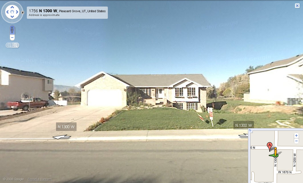
| Property Address: 1767 N 1300 WEST - PLEASANT GROVE |
|
| Mailing Address: 1767 N 1300 W PLEASANT GROVE, UT 84062-8945 |
|
| Acreage: 0.455 |
|
| Last Document:
18640-1995
|
|
| Subdivision Map Filing |
|
| Taxing Description:
LOT 2, PLAT A, LESLIE ESTATES SUBDV. AREA 0.455 AC.
*Taxing description NOT FOR LEGAL DOCUMENTS
|
|
- Owner Names
- Value History
- Tax History
- Location
- Photos
- Documents
- Aerial Image
| 2019... |
|
MORENO, PASCUAL IGNACIO |
|
| 2009-2018 |
|
JONES, AMMON H |
|
| 2009-2018 |
|
JONES, DAWN L |
|
| 2008 |
|
PORTER, GILBERT N |
|
| 1997-2007 |
|
ANDERSON, G BRETT |
|
| 1997-2007 |
|
ANDERSON, TAMARA L |
|
| 1996 |
|
ANDERSON, GAYLEN BRETT |
|
| 1996 |
|
ANDERSON, TAMARA L |
|
| 1995 |
|
WELCOME HOME REAL ESTATE AND INVESTMENTS INC |
|
| 1995NV |
|
OBERG, ROBERT H |
|
| 1995NV |
|
OBERG, WILLETTA |
|
| 1995NV |
|
OBERG, ROBERT H |
|
| 1995NV |
|
OBERG, WILLETTA |
|
| |
----- Real Estate Values ----- |
---Improvements--- |
---Greenbelt--- |
Total |
| Year |
Com |
Res |
Agr |
Tot |
Com |
Res |
Agr |
Tot |
Land |
Homesite |
Tot |
Market Value |
| 2024 |
$0 |
$324,000 |
$0 |
$324,000 |
$0 |
$364,900 |
$0 |
$364,900 |
$0 |
$0 |
$0 |
$688,900 |
| 2023 |
$0 |
$294,500 |
$0 |
$294,500 |
$0 |
$381,300 |
$0 |
$381,300 |
$0 |
$0 |
$0 |
$675,800 |
| 2022 |
$0 |
$309,700 |
$0 |
$309,700 |
$0 |
$411,100 |
$0 |
$411,100 |
$0 |
$0 |
$0 |
$720,800 |
| 2021 |
$0 |
$199,800 |
$0 |
$199,800 |
$0 |
$297,900 |
$0 |
$297,900 |
$0 |
$0 |
$0 |
$497,700 |
| 2020 |
$0 |
$185,000 |
$0 |
$185,000 |
$0 |
$278,400 |
$0 |
$278,400 |
$0 |
$0 |
$0 |
$463,400 |
| 2019 |
$0 |
$172,400 |
$0 |
$172,400 |
$0 |
$278,400 |
$0 |
$278,400 |
$0 |
$0 |
$0 |
$450,800 |
| 2018 |
$0 |
$143,000 |
$0 |
$143,000 |
$0 |
$242,100 |
$0 |
$242,100 |
$0 |
$0 |
$0 |
$385,100 |
| 2017 |
$0 |
$126,100 |
$0 |
$126,100 |
$0 |
$242,100 |
$0 |
$242,100 |
$0 |
$0 |
$0 |
$368,200 |
| 2016 |
$0 |
$79,900 |
$0 |
$79,900 |
$0 |
$255,900 |
$0 |
$255,900 |
$0 |
$0 |
$0 |
$335,800 |
| 2015 |
$0 |
$79,900 |
$0 |
$79,900 |
$0 |
$240,600 |
$0 |
$240,600 |
$0 |
$0 |
$0 |
$320,500 |
| 2014 |
$0 |
$78,200 |
$0 |
$78,200 |
$0 |
$221,900 |
$0 |
$221,900 |
$0 |
$0 |
$0 |
$300,100 |
| 2013 |
$0 |
$63,200 |
$0 |
$63,200 |
$0 |
$207,800 |
$0 |
$207,800 |
$0 |
$0 |
$0 |
$271,000 |
| 2012 |
$0 |
$54,700 |
$0 |
$54,700 |
$0 |
$188,900 |
$0 |
$188,900 |
$0 |
$0 |
$0 |
$243,600 |
| 2011 |
$0 |
$51,100 |
$0 |
$51,100 |
$0 |
$202,700 |
$0 |
$202,700 |
$0 |
$0 |
$0 |
$253,800 |
| 2010 |
$0 |
$58,260 |
$0 |
$58,260 |
$0 |
$217,029 |
$0 |
$217,029 |
$0 |
$0 |
$0 |
$275,289 |
| 2009 |
$0 |
$101,600 |
$0 |
$101,600 |
$0 |
$175,800 |
$0 |
$175,800 |
$0 |
$0 |
$0 |
$277,400 |
| 2008 |
$0 |
$128,600 |
$0 |
$128,600 |
$0 |
$180,100 |
$0 |
$180,100 |
$0 |
$0 |
$0 |
$308,700 |
| 2007 |
$0 |
$128,600 |
$0 |
$128,600 |
$0 |
$180,100 |
$0 |
$180,100 |
$0 |
$0 |
$0 |
$308,700 |
| 2006 |
$0 |
$49,700 |
$0 |
$49,700 |
$0 |
$220,400 |
$0 |
$220,400 |
$0 |
$0 |
$0 |
$270,100 |
| 2005 |
$0 |
$49,688 |
$0 |
$49,688 |
$0 |
$158,754 |
$0 |
$158,754 |
$0 |
$0 |
$0 |
$208,442 |
| 2004 |
$0 |
$49,688 |
$0 |
$49,688 |
$0 |
$158,754 |
$0 |
$158,754 |
$0 |
$0 |
$0 |
$208,442 |
| 2003 |
$0 |
$49,688 |
$0 |
$49,688 |
$0 |
$158,754 |
$0 |
$158,754 |
$0 |
$0 |
$0 |
$208,442 |
| 2002 |
$0 |
$49,688 |
$0 |
$49,688 |
$0 |
$158,754 |
$0 |
$158,754 |
$0 |
$0 |
$0 |
$208,442 |
| 2001 |
$0 |
$49,688 |
$0 |
$49,688 |
$0 |
$158,754 |
$0 |
$158,754 |
$0 |
$0 |
$0 |
$208,442 |
| 2000 |
$0 |
$46,437 |
$0 |
$46,437 |
$0 |
$139,884 |
$0 |
$139,884 |
$0 |
$0 |
$0 |
$186,321 |
| 1999 |
$0 |
$46,437 |
$0 |
$46,437 |
$0 |
$139,884 |
$0 |
$139,884 |
$0 |
$0 |
$0 |
$186,321 |
| 1998 |
$0 |
$41,095 |
$0 |
$41,095 |
$0 |
$123,791 |
$0 |
$123,791 |
$0 |
$0 |
$0 |
$164,886 |
| 1997 |
$0 |
$41,095 |
$0 |
$41,095 |
$0 |
$0 |
$0 |
$0 |
$0 |
$0 |
$0 |
$41,095 |
| 1996 |
$0 |
$40,464 |
$0 |
$40,464 |
$0 |
$0 |
$0 |
$0 |
$0 |
$0 |
$0 |
$40,464 |
| 1995 |
$0 |
$36,785 |
$0 |
$36,785 |
$0 |
$0 |
$0 |
$0 |
$0 |
$0 |
$0 |
$36,785 |
| Year |
General Taxes |
Adjustments |
Net Taxes |
Fees |
Payments |
Tax Balance* |
Balance Due |
Tax District |
| 2025 |
$0.00 |
$0.00 |
$0.00 |
$0.00 |
|
$0.00
|
$0.00 |
070 - PLEASANT GROVE CITY |
| 2024 |
$3,246.75 |
$0.00 |
$3,246.75 |
$0.00 |
|
$0.00
|
$0.00 |
070 - PLEASANT GROVE CITY |
| 2023 |
$3,042.28 |
($70.62) |
$2,971.66 |
$0.00 |
|
$0.00
|
$0.00 |
070 - PLEASANT GROVE CITY |
| 2022 |
$3,261.12 |
$0.00 |
$3,261.12 |
$0.00 |
|
$0.00
|
$0.00 |
070 - PLEASANT GROVE CITY |
| 2021 |
$2,688.90 |
$0.00 |
$2,688.90 |
$0.00 |
|
$0.00
|
$0.00 |
070 - PLEASANT GROVE CITY |
| 2020 |
$2,553.80 |
$0.00 |
$2,553.80 |
$0.00 |
|
$0.00
|
$0.00 |
070 - PLEASANT GROVE CITY |
| 2019 |
$2,402.29 |
$0.00 |
$2,402.29 |
$0.00 |
|
$0.00
|
$0.00 |
070 - PLEASANT GROVE CITY |
| 2018 |
$2,170.37 |
$0.00 |
$2,170.37 |
$0.00 |
|
$0.00
|
$0.00 |
070 - PLEASANT GROVE CITY |
| 2017 |
$2,143.77 |
$0.00 |
$2,143.77 |
$0.00 |
|
$0.00
|
$0.00 |
070 - PLEASANT GROVE CITY |
| 2016 |
$2,025.13 |
$0.00 |
$2,025.13 |
$0.00 |
|
$0.00
|
$0.00 |
070 - PLEASANT GROVE CITY |
| 2015 |
$2,041.09 |
$0.00 |
$2,041.09 |
$0.00 |
|
$0.00
|
$0.00 |
070 - PLEASANT GROVE CITY |
| 2014 |
$1,929.33 |
$0.00 |
$1,929.33 |
$0.00 |
|
$0.00
|
$0.00 |
070 - PLEASANT GROVE CITY |
| 2013 |
$1,888.31 |
$0.00 |
$1,888.31 |
$0.00 |
|
$0.00
|
$0.00 |
070 - PLEASANT GROVE CITY |
| 2012 |
$1,735.17 |
$0.00 |
$1,735.17 |
$0.00 |
|
$0.00
|
$0.00 |
070 - PLEASANT GROVE CITY |
| 2011 |
$1,797.08 |
$0.00 |
$1,797.08 |
$0.00 |
|
$0.00
|
$0.00 |
070 - PLEASANT GROVE CITY |
| 2010 |
$1,823.87 |
$0.00 |
$1,823.87 |
$0.00 |
|
$0.00
|
$0.00 |
070 - PLEASANT GROVE CITY |
| 2009 |
$1,695.21 |
$0.00 |
$1,695.21 |
$0.00 |
|
$0.00
|
$0.00 |
070 - PLEASANT GROVE CITY |
| 2008 |
$1,744.71 |
$0.00 |
$1,744.71 |
$0.00 |
|
$0.00
|
$0.00 |
070 - PLEASANT GROVE CITY |
| 2007 |
$1,675.61 |
$0.00 |
$1,675.61 |
$0.00 |
|
$0.00
|
$0.00 |
070 - PLEASANT GROVE CITY |
| 2006 |
$1,569.19 |
$0.00 |
$1,569.19 |
$0.00 |
|
$0.00
|
$0.00 |
070 - PLEASANT GROVE CITY |
| 2005 |
$1,404.95 |
$0.00 |
$1,404.95 |
$0.00 |
|
$0.00
|
$0.00 |
070 - PLEASANT GROVE CITY |
| 2004 |
$1,422.60 |
$0.00 |
$1,422.60 |
$0.00 |
|
$0.00
|
$0.00 |
070 - PLEASANT GROVE CITY |
| 2003 |
$1,410.80 |
$0.00 |
$1,410.80 |
$0.00 |
|
$0.00
|
$0.00 |
070 - PLEASANT GROVE CITY |
| 2002 |
$1,303.15 |
$0.00 |
$1,303.15 |
$0.00 |
|
$0.00
|
$0.00 |
070 - PLEASANT GROVE CITY |
| 2001 |
$1,286.18 |
$0.00 |
$1,286.18 |
$0.00 |
|
$0.00
|
$0.00 |
070 - PLEASANT GROVE CITY |
| 2000 |
$1,194.26 |
$0.00 |
$1,194.26 |
$0.00 |
|
$0.00
|
$0.00 |
070 - PLEASANT GROVE CITY |
| 1999 |
$1,207.37 |
$0.00 |
$1,207.37 |
$0.00 |
|
$0.00
|
$0.00 |
070 - PLEASANT GROVE CITY |
| 1998 |
$1,047.62 |
$0.00 |
$1,047.62 |
$0.00 |
|
$0.00
|
$0.00 |
070 - PLEASANT GROVE CITY |
| 1997 |
$457.59 |
$0.00 |
$457.59 |
$0.00 |
|
$0.00
|
$0.00 |
070 - PLEASANT GROVE CITY |
| 1996 |
$445.18 |
$0.00 |
$445.18 |
$0.00 |
|
$0.00
|
$0.00 |
070 - PLEASANT GROVE CITY |
| 1995 |
$455.29 |
$0.00 |
$455.29 |
$0.00 |
|
$0.00
|
$0.00 |
070 - PLEASANT GROVE CITY |
* Note: Original tax amount (Does not include applicable interest and/or fees).
| Entry # |
Date |
Recorded |
Type |
Party1 (Grantor) |
Party2 (Grantee) |
| 37495-2023 |
06/02/2023 |
06/09/2023 |
D TR |
MORENO, PASCUAL IGNACIO |
MOUNTAIN AMERICA FEDERAL CREDIT UNION |
| 54288-2022 |
04/25/2022 |
05/02/2022 |
REC |
WFG NATIONAL TITLE INSURANCE COMPANY TEE |
MORENO, PASCUAL INGNACIO |
| 54287-2022 |
04/19/2022 |
05/02/2022 |
SUB TEE |
FIRST NATIONAL BANK OF AMERICA |
WFG NATIONAL TITLE INSURANCE COMPANY SUBTEE |
| 44762-2022 |
04/06/2022 |
04/11/2022 |
D TR |
MORENO, PASCUAL IGNACIO |
MOUNTAIN AMERICA FEDERAL CREDIT UNION |
| 18716-2019 |
03/06/2019 |
03/06/2019 |
REC |
FIRST AMERICAN TITLE INSURANCE COMPANY TEE |
JONES, AMON H & DAWN L |
| 18186-2019 |
03/01/2019 |
03/05/2019 |
SUB TEE |
MORTGAGE ELECTRONIC REGISTRATION SYSTEMS INC |
FIRST AMERICAN TITLE SUCTEE |
| 6152-2019 |
12/28/2018 |
01/24/2019 |
REC |
UTAH COMMUNITY CREDIT UNION TEE |
JONES, AMMON H & DAWN L |
| 119414-2018 |
12/18/2018 |
12/18/2018 |
D TR |
MORENO, PASCUAL IGNACIO |
FIRST NATIONAL BANK OF AMERICA |
| 119379-2018 |
12/13/2018 |
12/18/2018 |
WD |
JONES, AMMON H & DAWN L |
MORENO, PASCUAL IGNACIO |
| 457-2017 |
12/29/2016 |
01/04/2017 |
RC |
UTAH COMMUNITY FEDERAL CREDIT UNION |
WHOM OF INTEREST |
| 456-2017 |
12/29/2016 |
01/04/2017 |
D TR |
JONES, AMMON H & DAWN L |
UTAH COMMUNITY CREDIT UNION |
| 37682-2013 |
04/12/2013 |
04/18/2013 |
RSUBTEE |
MORTGAGE ELECTRONIC REGISTRATION SYSTEMS INC (ET AL) |
JONES, AMMON H & DAWN L |
| 14394-2013 |
02/08/2013 |
02/13/2013 |
D TR |
JONES, AMMON H & DAWN L |
AMERISAVE MORTGAGE CORPORATION |
| 9780-2009 |
01/21/2009 |
01/30/2009 |
RSUBTEE |
MORTGAGE ELECTRONIC REGISTRATION SYSTEMS INC (ET AL) |
JONES, AMMON H & DAWN L |
| 3554-2009 |
01/09/2009 |
01/14/2009 |
D TR |
JONES, AMMON H & DAWN L |
COUNTRYWIDE BANK |
| 73147-2008 |
06/17/2008 |
06/25/2008 |
RSUBTEE |
MORTGAGE ELECTRONIC REGISTRATION SYSTEMS INC (ET AL) |
PORTER, GILBERT N |
| 72918-2008 |
06/16/2008 |
06/24/2008 |
RSUBTEE |
MORTGAGE ELECTRONIC REGISTRATION SYSTEMS INC (ET AL) |
PORTER, GILBERT N |
| 46836-2008 |
04/21/2008 |
04/21/2008 |
REC |
FIRST AMERICAN TITLE INSURANCE AGENCY LLC TEE |
PORTER, GILBERT N |
| 42486-2008 |
04/09/2008 |
04/10/2008 |
D TR |
JONES, AMMON H & DAWN L |
COUNTRYWIDE BANK |
| 42485-2008 |
04/09/2008 |
04/10/2008 |
WD |
PORTER, GILBERT N |
JONES, AMMON H & DAWN L |
| 172467-2007 |
12/13/2007 |
12/14/2007 |
D TR |
PORTER, GILBERT N |
PORTER, DON GILBERT |
| 62813-2007 |
04/19/2007 |
04/30/2007 |
REC |
FIRST AMERICAN TITLE COMPANY TEE |
ANDERSON, G BRETT & TAMARA L |
| 62812-2007 |
04/19/2007 |
04/30/2007 |
SUB TEE |
MORTGAGE ELECTRONIC REGISTRATION SYSTEMS INC |
FIRST AMERICAN TITLE COMPANY SUCTEE |
| 50491-2007 |
03/20/2007 |
04/06/2007 |
REC |
BACKMAN TITLE SERVICES LTD SUCTEE |
ANDERSON, G BRETT & TAMARA L |
| 50490-2007 |
03/22/2007 |
04/06/2007 |
SUB TEE |
ALPINE CREDIT UNION |
BACKMAN TITLE SERVICES LTD SUCTEE |
| 45115-2007 |
03/27/2007 |
03/28/2007 |
D TR |
PORTER, GILBERT N |
COUNTRYWIDE BANK |
| 45114-2007 |
03/27/2007 |
03/28/2007 |
D TR |
PORTER, GILBERT N |
COUNTRYWIDE BANK |
| 45057-2007 |
03/23/2007 |
03/28/2007 |
WD |
ANDERSON, G BRETT & TAMARA L |
PORTER, GILBERT N |
| 188901-2003 |
09/25/2003 |
12/01/2003 |
REC |
HARRISON, MICHAEL TEE |
ANDERSON, BRETT G & TAMARA L |
| 78615-2003 |
05/16/2003 |
05/23/2003 |
D TR |
ANDERSON, G BRETT & TAMARA L |
GMAC BANK |
| 94411-2002 |
07/26/2002 |
08/16/2002 |
REC |
WELLS FARGO FINANCIAL NATIONAL BANK SUCTEE |
ANDERSON, G BRETT & TAMARA L |
| 94410-2002 |
02/13/2002 |
08/16/2002 |
SUB TEE |
WELLS FARGO HOME MORTGAGE INC |
WELLS FARGO FINANCIAL NATIONAL BANK SUCTEE |
| 118387-2001 |
11/09/2001 |
11/15/2001 |
D TR |
ANDERSON, G BRETT & TAMARA L |
LONG BEACH MORTGAGE COMPANY |
| 103618-1997 |
12/26/1997 |
12/30/1997 |
RC |
ALPINE CREDIT UNION |
WHOM OF INTEREST |
| 103617-1997 |
12/26/1997 |
12/30/1997 |
TR D |
ANDERSON, G BRETT & TAMARA L |
ALPINE CREDIT UNION |
| 8633-1997 |
01/30/1997 |
02/04/1997 |
REC |
FOXLEY, DOUGLAS S TEE |
ANDERSON, GAYLEN BRETT & TAMARA L |
| 62572-1996 |
07/30/1996 |
07/31/1996 |
D TR |
ANDERSON, G BRETT & TAMARA L |
NORWEST MORTGAGE INC |
| 62571-1996 |
07/30/1996 |
07/31/1996 |
QCD |
ANDERSON, GAYLEN BRETT & TAMARA L |
ANDERSON, G BRETT & TAMARA L |
| 77694-1995 |
11/10/1995 |
11/10/1995 |
PRO COV |
WELCOME HOME REAL ESTATE & INVESTMENTS INC |
WHOM OF INTEREST |
| 76846-1995 |
11/06/1995 |
11/08/1995 |
RESOL |
UTAH COUNTY COMMISSIONERS |
WHOM OF INTEREST |
| 18641-1995 |
03/22/1995 |
03/27/1995 |
TR D |
ANDERSON, GAYLEN BRETT & TAMARA L |
BEEHIVE CREDIT UNION |
| 18640-1995 |
03/22/1995 |
03/27/1995 |
WD |
WELCOME HOME REAL ESTATE AND INVESTMENT INC |
ANDERSON, GAYLEN BRETT & TAMARA L |
| 73004-1994 |
09/07/1994 |
09/15/1994 |
REC |
ZIONS FIRST NATIONAL BANK TEE |
OBERG, KEVEN R & KAREN B |
| 44967-1994 |
05/10/1994 |
05/27/1994 |
QCD |
OBERG, ROBERT H & WILLETTA |
WELCOME HOME REAL ESTATE AND INVESTMENTS INC |
| 44923-1994 |
05/27/1994 |
05/27/1994 |
PRO COV |
WELCOME HOME REAL ESTATE & INVESTMENTS INC |
WHOM OF INTEREST |
| 17955-1994 |
01/04/1994 |
03/03/1994 |
S PLAT |
LINES, LEON L (ET AL) |
LESLIE ESTATES PLAT A |
| 11874-1994 |
01/17/1994 |
02/09/1994 |
AS |
SECURITY BANCORP INC DBA (ET AL) |
NATIONAL MORTGAGE COMPANY |
Main Menu Comments or Concerns on Value/Appraisal - Assessor's Office
Documents/Owner/Parcel information - Recorder's Office
Address Change for Tax Notice
This page was created on 4/23/2025 12:40:09 AM |
