Property Information
mobile view
| Serial Number: 51:731:0001 |
Serial Life: 2023... |
|
|
 Total Photos: 2
|
| |
|
|
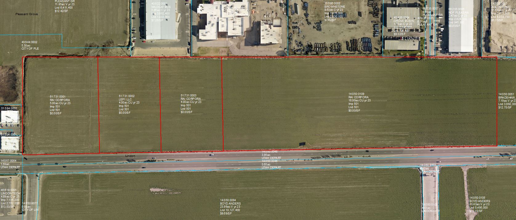
| Property Address: 1670 W 700 NORTH - LINDON |
|
| Mailing Address: 210 N PRESTON DR ALPINE, UT 84004-1945 |
|
| Acreage: 4.99723 |
|
| Last Document:
94223-2022
|
|
| Subdivision Map Filing |
|
| Taxing Description:
LOT 1, PLAT A, RAI SUB AREA 4.997 AC.
*Taxing description NOT FOR LEGAL DOCUMENTS
|
|
- Owner Names
- Value History
- Tax History
- Location
- Photos
- Documents
- Aerial Image
| |
----- Real Estate Values ----- |
---Improvements--- |
---Greenbelt--- |
Total |
| Year |
Com |
Res |
Agr |
Tot |
Com |
Res |
Agr |
Tot |
Land |
Homesite |
Tot |
Market Value |
| 2024 |
$2,902,100 |
$0 |
$0 |
$2,902,100 |
$0 |
$0 |
$0 |
$0 |
$0 |
$0 |
$0 |
$2,902,100 |
| 2023 |
$2,867,300 |
$0 |
$0 |
$2,867,300 |
$0 |
$0 |
$0 |
$0 |
$0 |
$0 |
$0 |
$2,867,300 |
| Year |
General Taxes |
Adjustments |
Net Taxes |
Fees |
Payments |
Tax Balance* |
Balance Due |
Tax District |
| 2025 |
$0.00 |
$0.00 |
$0.00 |
$0.00 |
|
$0.00
|
$0.00 |
085 - LINDON CITY W/WATER CONS |
| 2024 |
$23,576.66 |
$0.00 |
$23,576.66 |
$0.00 |
|
$0.00
|
$0.00 |
085 - LINDON CITY W/WATER CONS |
| 2023 |
$21,688.26 |
$0.00 |
$21,688.26 |
$0.00 |
|
$0.00
|
$0.00 |
085 - LINDON CITY W/WATER CONS |
* Note: Original tax amount (Does not include applicable interest and/or fees).
| Entry # |
Date |
Recorded |
Type |
Party1 (Grantor) |
Party2 (Grantee) |
| 110916-2022 |
10/19/2022 |
10/19/2022 |
R FARM |
UTAH COUNTY TREASURER |
BLACKHURST, PAUL & WANDA (ET AL) |
| 104704-2022 |
09/26/2022 |
09/27/2022 |
W FARM |
RAI CORP (ET AL) |
WHOM OF INTEREST |
| 94223-2022 |
08/15/2022 |
08/25/2022 |
S PLAT |
BRADSHAW, WARREN TEE (ET AL) |
RAI PLAT A |
Main Menu Comments or Concerns on Value/Appraisal - Assessor's Office
Documents/Owner/Parcel information - Recorder's Office
Address Change for Tax Notice
This page was created on 2/26/2025 10:56:41 AM |
