Property Information
mobile view
| Serial Number: 52:415:0001 |
Serial Life: 1993... |
|
|
 Total Photos: 1
|
| |
|
|
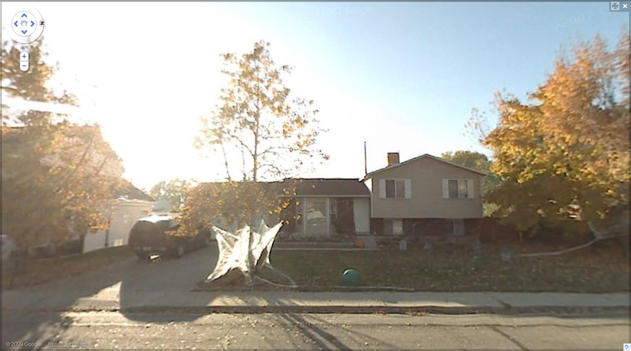
| Property Address: 581 N 550 WEST - OREM |
|
| Mailing Address: 581 N 550 W OREM, UT 84057-3724 |
|
| Acreage: 0.35 |
|
| Last Document:
60939-1992
|
|
| Subdivision Map Filing |
|
| Taxing Description:
LOT 1, PLAT A, SUE'S LANDING SUB. AREA .35 ACRE.
*Taxing description NOT FOR LEGAL DOCUMENTS
|
|
- Owner Names
- Value History
- Tax History
- Location
- Photos
- Documents
- Aerial Image
| 2013... |
|
YOUNG, CHELSIE |
|
| 2013... |
|
YOUNG, TREVOR |
|
| 2009-2012 |
|
HAYES, KARLA K |
|
| 2009-2012 |
|
HAYES, ROBERT C |
|
| 2009NV |
|
HAYES, ROBERT C |
|
| 2007-2008 |
|
HAYES, KARLA K |
|
| 2007-2008 |
|
HAYES, ROBERT C |
|
| 2007NV |
|
HAYES, ROBERT C |
|
| 2004-2006 |
|
HAYES, KARLA K |
|
| 2004-2006 |
|
HAYES, KARLA K |
|
| 2004-2006 |
|
HAYES, ROBERT C |
|
| 2003 |
|
HAYES, KARLA K |
|
| 2003 |
|
HAYES, ROBERT C |
|
| 2002 |
|
HAYES, CARLA K |
|
| 2002 |
|
HAYES, ROBERT C |
|
| 2000-2001 |
|
SCHAUGAARD, CHAD |
|
| 2000-2001 |
|
STEINECKERT, JAY |
|
| 2000-2001 |
|
STEINECKERT, LEANNA |
|
| 2000-2001 |
|
STEINECKERT, MISHELLE |
|
| 1994-1999 |
|
MILES, DEBORA F |
|
| 1994-1999 |
|
MILES, MATHEW J |
|
| 1993 |
|
BASSETT, JUNE L |
|
| |
----- Real Estate Values ----- |
---Improvements--- |
---Greenbelt--- |
Total |
| Year |
Com |
Res |
Agr |
Tot |
Com |
Res |
Agr |
Tot |
Land |
Homesite |
Tot |
Market Value |
| 2024 |
$0 |
$205,700 |
$0 |
$205,700 |
$0 |
$235,500 |
$0 |
$235,500 |
$0 |
$0 |
$0 |
$441,200 |
| 2023 |
$0 |
$205,700 |
$0 |
$205,700 |
$0 |
$238,900 |
$0 |
$238,900 |
$0 |
$0 |
$0 |
$444,600 |
| 2022 |
$0 |
$219,300 |
$0 |
$219,300 |
$0 |
$204,800 |
$0 |
$204,800 |
$0 |
$0 |
$0 |
$424,100 |
| 2021 |
$0 |
$129,000 |
$0 |
$129,000 |
$0 |
$189,600 |
$0 |
$189,600 |
$0 |
$0 |
$0 |
$318,600 |
| 2020 |
$0 |
$103,200 |
$0 |
$103,200 |
$0 |
$184,100 |
$0 |
$184,100 |
$0 |
$0 |
$0 |
$287,300 |
| 2019 |
$0 |
$103,200 |
$0 |
$103,200 |
$0 |
$174,900 |
$0 |
$174,900 |
$0 |
$0 |
$0 |
$278,100 |
| 2018 |
$0 |
$99,200 |
$0 |
$99,200 |
$0 |
$155,800 |
$0 |
$155,800 |
$0 |
$0 |
$0 |
$255,000 |
| 2017 |
$0 |
$87,300 |
$0 |
$87,300 |
$0 |
$135,500 |
$0 |
$135,500 |
$0 |
$0 |
$0 |
$222,800 |
| 2016 |
$0 |
$63,500 |
$0 |
$63,500 |
$0 |
$120,900 |
$0 |
$120,900 |
$0 |
$0 |
$0 |
$184,400 |
| 2015 |
$0 |
$61,900 |
$0 |
$61,900 |
$0 |
$105,100 |
$0 |
$105,100 |
$0 |
$0 |
$0 |
$167,000 |
| 2014 |
$0 |
$61,100 |
$0 |
$61,100 |
$0 |
$93,400 |
$0 |
$93,400 |
$0 |
$0 |
$0 |
$154,500 |
| 2013 |
$0 |
$56,200 |
$0 |
$56,200 |
$0 |
$93,400 |
$0 |
$93,400 |
$0 |
$0 |
$0 |
$149,600 |
| 2012 |
$0 |
$50,600 |
$0 |
$50,600 |
$0 |
$109,200 |
$0 |
$109,200 |
$0 |
$0 |
$0 |
$159,800 |
| 2011 |
$0 |
$54,000 |
$0 |
$54,000 |
$0 |
$110,800 |
$0 |
$110,800 |
$0 |
$0 |
$0 |
$164,800 |
| 2010 |
$0 |
$54,970 |
$0 |
$54,970 |
$0 |
$120,232 |
$0 |
$120,232 |
$0 |
$0 |
$0 |
$175,202 |
| 2009 |
$0 |
$83,400 |
$0 |
$83,400 |
$0 |
$98,100 |
$0 |
$98,100 |
$0 |
$0 |
$0 |
$181,500 |
| 2008 |
$0 |
$83,400 |
$0 |
$83,400 |
$0 |
$113,700 |
$0 |
$113,700 |
$0 |
$0 |
$0 |
$197,100 |
| 2007 |
$0 |
$86,900 |
$0 |
$86,900 |
$0 |
$118,400 |
$0 |
$118,400 |
$0 |
$0 |
$0 |
$205,300 |
| 2006 |
$0 |
$41,800 |
$0 |
$41,800 |
$0 |
$108,200 |
$0 |
$108,200 |
$0 |
$0 |
$0 |
$150,000 |
| 2005 |
$0 |
$39,840 |
$0 |
$39,840 |
$0 |
$103,060 |
$0 |
$103,060 |
$0 |
$0 |
$0 |
$142,900 |
| 2004 |
$0 |
$39,840 |
$0 |
$39,840 |
$0 |
$103,060 |
$0 |
$103,060 |
$0 |
$0 |
$0 |
$142,900 |
| 2003 |
$0 |
$39,840 |
$0 |
$39,840 |
$0 |
$103,060 |
$0 |
$103,060 |
$0 |
$0 |
$0 |
$142,900 |
| 2002 |
$0 |
$39,840 |
$0 |
$39,840 |
$0 |
$103,060 |
$0 |
$103,060 |
$0 |
$0 |
$0 |
$142,900 |
| 2001 |
$0 |
$39,840 |
$0 |
$39,840 |
$0 |
$103,060 |
$0 |
$103,060 |
$0 |
$0 |
$0 |
$142,900 |
| 2000 |
$0 |
$37,234 |
$0 |
$37,234 |
$0 |
$94,507 |
$0 |
$94,507 |
$0 |
$0 |
$0 |
$131,741 |
| 1999 |
$0 |
$34,798 |
$0 |
$34,798 |
$0 |
$88,324 |
$0 |
$88,324 |
$0 |
$0 |
$0 |
$123,122 |
| 1998 |
$0 |
$34,798 |
$0 |
$34,798 |
$0 |
$88,324 |
$0 |
$88,324 |
$0 |
$0 |
$0 |
$123,122 |
| 1997 |
$0 |
$34,798 |
$0 |
$34,798 |
$0 |
$88,324 |
$0 |
$88,324 |
$0 |
$0 |
$0 |
$123,122 |
| 1996 |
$0 |
$32,875 |
$0 |
$32,875 |
$0 |
$83,443 |
$0 |
$83,443 |
$0 |
$0 |
$0 |
$116,318 |
| 1995 |
$0 |
$29,886 |
$0 |
$29,886 |
$0 |
$83,443 |
$0 |
$83,443 |
$0 |
$0 |
$0 |
$113,329 |
| 1994 |
$0 |
$17,477 |
$0 |
$17,477 |
$0 |
$67,293 |
$0 |
$67,293 |
$0 |
$0 |
$0 |
$84,770 |
| 1993 |
$0 |
$17,477 |
$0 |
$17,477 |
$0 |
$67,293 |
$0 |
$67,293 |
$0 |
$0 |
$0 |
$84,770 |
| Year |
General Taxes |
Adjustments |
Net Taxes |
Fees |
Payments |
Tax Balance* |
Balance Due |
Tax District |
| 2025 |
$0.00 |
$0.00 |
$0.00 |
$0.00 |
|
$0.00
|
$0.00 |
090 - OREM CITY |
| 2024 |
$1,984.47 |
$0.00 |
$1,984.47 |
$0.00 |
|
$0.00
|
$0.00 |
090 - OREM CITY |
| 2023 |
$1,860.63 |
$0.00 |
$1,860.63 |
$0.00 |
|
$0.00
|
$0.00 |
090 - OREM CITY |
| 2022 |
$1,831.98 |
$0.00 |
$1,831.98 |
$0.00 |
|
$0.00
|
$0.00 |
090 - OREM CITY |
| 2021 |
$1,652.07 |
$0.00 |
$1,652.07 |
$0.00 |
|
$0.00
|
$0.00 |
090 - OREM CITY |
| 2020 |
$1,515.84 |
$0.00 |
$1,515.84 |
$0.00 |
|
$0.00
|
$0.00 |
090 - OREM CITY |
| 2019 |
$1,411.01 |
$0.00 |
$1,411.01 |
$0.00 |
|
$0.00
|
$0.00 |
090 - OREM CITY |
| 2018 |
$1,354.11 |
$0.00 |
$1,354.11 |
$0.00 |
|
$0.00
|
$0.00 |
090 - OREM CITY |
| 2017 |
$1,214.74 |
$0.00 |
$1,214.74 |
$0.00 |
|
$0.00
|
$0.00 |
090 - OREM CITY |
| 2016 |
$1,090.27 |
$0.00 |
$1,090.27 |
$0.00 |
|
$0.00
|
$0.00 |
090 - OREM CITY |
| 2015 |
$1,044.06 |
$0.00 |
$1,044.06 |
$0.00 |
|
$0.00
|
$0.00 |
090 - OREM CITY |
| 2014 |
$970.33 |
$0.00 |
$970.33 |
$0.00 |
|
$0.00
|
$0.00 |
090 - OREM CITY |
| 2013 |
$1,013.20 |
$0.00 |
$1,013.20 |
$0.00 |
|
$0.00
|
$0.00 |
090 - OREM CITY |
| 2012 |
$1,104.60 |
$0.00 |
$1,104.60 |
$0.00 |
|
$0.00
|
$0.00 |
090 - OREM CITY |
| 2011 |
$1,133.73 |
$0.00 |
$1,133.73 |
$0.00 |
|
$0.00
|
$0.00 |
090 - OREM CITY |
| 2010 |
$1,128.40 |
$0.00 |
$1,128.40 |
$0.00 |
|
$0.00
|
$0.00 |
090 - OREM CITY |
| 2009 |
$1,083.60 |
$0.00 |
$1,083.60 |
$0.00 |
|
$0.00
|
$0.00 |
090 - OREM CITY |
| 2008 |
$1,090.45 |
$0.00 |
$1,090.45 |
$0.00 |
|
$0.00
|
$0.00 |
090 - OREM CITY |
| 2007 |
$1,122.83 |
$0.00 |
$1,122.83 |
$0.00 |
|
$0.00
|
$0.00 |
090 - OREM CITY |
| 2006 |
$873.59 |
$0.00 |
$873.59 |
$0.00 |
|
$0.00
|
$0.00 |
090 - OREM CITY |
| 2005 |
$939.37 |
$0.00 |
$939.37 |
$0.00 |
|
$0.00
|
$0.00 |
090 - OREM CITY |
| 2004 |
$922.71 |
$0.00 |
$922.71 |
$0.00 |
|
$0.00
|
$0.00 |
090 - OREM CITY |
| 2003 |
$895.35 |
$0.00 |
$895.35 |
$0.00 |
|
$0.00
|
$0.00 |
090 - OREM CITY |
| 2002 |
$818.25 |
$0.00 |
$818.25 |
$0.00 |
|
$0.00
|
$0.00 |
090 - OREM CITY |
| 2001 |
$810.39 |
$0.00 |
$810.39 |
$0.00 |
|
$0.00
|
$0.00 |
090 - OREM CITY |
| 2000 |
$772.47 |
$0.00 |
$772.47 |
$0.00 |
|
$0.00
|
$0.00 |
090 - OREM CITY |
| 1999 |
$743.26 |
$0.00 |
$743.26 |
$0.00 |
|
$0.00
|
$0.00 |
090 - OREM CITY |
| 1998 |
$701.82 |
$0.00 |
$701.82 |
$0.00 |
|
$0.00
|
$0.00 |
090 - OREM CITY |
| 1997 |
$698.91 |
$0.00 |
$698.91 |
$0.00 |
|
$0.00
|
$0.00 |
090 - OREM CITY |
| 1996 |
$603.22 |
$0.00 |
$603.22 |
$0.00 |
|
$0.00
|
$0.00 |
090 - OREM CITY |
| 1995 |
$665.07 |
$0.00 |
$665.07 |
$0.00 |
|
$0.00
|
$0.00 |
090 - OREM CITY |
| 1994 |
$792.59 |
$0.00 |
$792.59 |
$0.00 |
|
$0.00
|
$0.00 |
090 - OREM CITY |
| 1993 |
$701.44 |
$0.00 |
$701.44 |
$0.00 |
|
$0.00
|
$0.00 |
090 - OREM CITY |
* Note: Original tax amount (Does not include applicable interest and/or fees).
| Entry # |
Date |
Recorded |
Type |
Party1 (Grantor) |
Party2 (Grantee) |
| 75616-2012 |
08/31/2012 |
09/05/2012 |
CAN ND |
HALLIDAY, PAUL M JR SUCTEE |
HAYES, ROBERT C |
| 47867-2012 |
06/07/2012 |
06/08/2012 |
D TR |
YOUNG, TREVOR & CHELSIE |
FIRST COLONY MORTGAGE CORPORATION |
| 47839-2012 |
06/07/2012 |
06/08/2012 |
WD |
HAYES, ROBERT C & KARLA K |
YOUNG, TREVOR & CHELSIE |
| 2270-2012 |
12/23/2011 |
01/10/2012 |
SUB TEE |
U S BANK NATIONAL ASSOCIATION |
HALLIDAY, PAUL M JR SUCTEE |
| 2269-2012 |
01/10/2012 |
01/10/2012 |
ND |
HALLIDAY, PAUL M JR SUCTEE |
HAYES, ROBERT C |
| 2268-2012 |
01/05/2012 |
01/10/2012 |
AS |
MORTGAGE ELECTRONIC REGISTRATION SYSTEMS INC |
U S BANK |
| 129098-2008 |
12/04/2008 |
12/10/2008 |
RSUBTEE |
MORTGAGE ELECTRONIC REGISTRATION SYSTEMS INC (ET AL) |
HAYES, ROBERT C |
| 121060-2008 |
11/06/2008 |
11/12/2008 |
RSUBTEE |
MORTGAGE ELECTRONIC REGISTRATION SYSTEMS INC (ET AL) |
HAYES, ROBERT C |
| 112278-2008 |
10/07/2008 |
10/14/2008 |
WD |
HAYES, ROBERT C |
HAYES, ROBERT C & KARLA K |
| 112277-2008 |
10/07/2008 |
10/14/2008 |
D TR |
HAYES, ROBERT C |
ACCESS MORTGAGE LLC |
| 112276-2008 |
10/07/2008 |
10/14/2008 |
WD |
HAYES, ROBERT C & KARLA K |
HAYES, ROBERT C |
| 62098-2008 |
05/28/2008 |
05/28/2008 |
SCRIVAF |
DIRECT TITLE INSURANCE AGENCY INC (ET AL) |
WHOM OF INTEREST |
| 155931-2006 |
11/10/2006 |
11/21/2006 |
RSUBTEE |
MORTGAGE ELECTRONIC REGISTRATION SYSTEMS INC (ET AL) |
HAYES, ROBERT C & KARLA K |
| 132808-2006 |
09/13/2006 |
10/06/2006 |
REC |
LUNDBERG, J SCOTT SUCTEE |
HAYES, ROBERT C & KARLA K |
| 132807-2006 |
09/11/2006 |
10/06/2006 |
SUB TEE |
MORTGAGE ELECTRONIC REGISTRATION SYSTEMS INC |
LUNDBERG, J SCOTT SUCTEE |
| 111266-2006 |
08/21/2006 |
08/25/2006 |
QCD |
HAYES, ROBERT C |
HAYES, ROBERT C & KARLA K |
| 111265-2006 |
08/21/2006 |
08/25/2006 |
D TR |
HAYES, ROBERT C |
TAYLOR BEAN & WHITAKER MORTGAGE CORP |
| 111264-2006 |
08/21/2006 |
08/25/2006 |
D TR |
HAYES, ROBERT C |
TAYLOR BEAN & WHITAKER MORTGAGE CORP |
| 111263-2006 |
08/21/2006 |
08/25/2006 |
QCD |
HAYES, ROBERT C & KARLA K |
HAYES, ROBERT C |
| 19084-2004 |
02/03/2004 |
02/20/2004 |
RSUBTEE |
MORTGAGE ELECTRONIC REGISTRATION SYSTEMS INC (ET AL) |
HAYES, ROBERT C & KARLA K |
| 16448-2004 |
10/27/2003 |
02/12/2004 |
REC |
INWEST TITLE SERVICES INC |
HAYES, ROBERT C & KARLA K |
| 14209-2004 |
01/15/2004 |
02/09/2004 |
D TR |
HAYES, ROBERT C & KARLA K |
WESTERN THRIFT & LOAN |
| 191862-2003 |
11/18/2003 |
12/05/2003 |
REC |
WELLS FARGO FINANCIAL NATIONAL BANK TEE |
HAYES, ROBERT C & KARLA K |
| 191861-2003 |
11/18/2003 |
12/05/2003 |
SUC TEE |
MORTGAGE ELECTRONIC REGISTRATION SYSTEMS INC |
WELLS FARGO FINANCIAL NATIONAL BANK SUCTEE |
| 177488-2003 |
08/15/2003 |
11/06/2003 |
REC |
INWEST TITLE SERVICES INC TEE |
HAYES, ROBERT C & KARLA K |
| 172660-2003 |
10/21/2003 |
10/27/2003 |
D TR |
HAYES, ROBERT C & KARLA K |
WESTERN THRIFT & LOAN |
| 143595-2003 |
08/15/2003 |
08/29/2003 |
SUB AGR |
MORTGAGE ELECTRONIC REGISTRATION SYSTEMS INC |
SIB MORTGAGE |
| 143594-2003 |
08/25/2003 |
08/29/2003 |
D TR |
HAYES, ROBERT C & KARLA K |
SIB MORTGAGE CORP |
| 143593-2003 |
08/21/2003 |
08/29/2003 |
PA |
HAYES, KARLA K |
HAYES, ROBERT C |
| 131167-2003 |
06/27/2003 |
08/14/2003 |
REC |
WELLS FARGO FINANCIAL NATIONAL BANK TEE |
HAYES, ROBERT C & KARLA K |
| 131166-2003 |
06/27/2003 |
08/14/2003 |
SUC TEE |
MORTGAGE ELECTRONIC REGISTRATION SYSTEMS INC |
WELLS FARGO FINANCIAL NATIONAL BANK SUCTEE |
| 49071-2003 |
03/20/2003 |
04/01/2003 |
SUB AGR |
MORTGAGE ELECTRONIC REGISTRATION SYSTEMS INC |
NEW FREEDOM MORTGAGE CORPORATION |
| 49070-2003 |
03/25/2003 |
04/01/2003 |
D TR |
HAYES, ROBERT C & KARLA K |
NEW FREEDOM MORTGAGE CORPORATION |
| 49069-2003 |
03/24/2003 |
04/01/2003 |
QCD |
HAYES, ROBERT C & CARLA K |
HAYES, ROBERT C & KARLA K |
| 33879-2003 |
01/13/2003 |
03/07/2003 |
REC |
RIVERS, ROD TEE |
HAYES, ROBERT CHARLES & KARLA KAY |
| 33878-2003 |
12/31/2002 |
03/07/2003 |
SUB TEE |
MORTGAGE ELECTRONIC REGISTRATION SYSTEMS INC |
RIVERS, ROD SUCTEE |
| 144853-2002 |
11/25/2002 |
11/29/2002 |
SUB AGR |
MORTGAGE ELECTRONIC REGISTRATION SYSTEMS INC |
MORTGAGE ELECTRONIC REGISTRATION SYSTEMS INC |
| 144852-2002 |
11/22/2002 |
11/29/2002 |
D TR |
HAYES, ROBERT C & KARLA K |
SCME MORTGAGE BANKERS INC |
| 33362-2002 |
02/13/2002 |
03/25/2002 |
D TR |
HAYES, ROBERT C & KARLA K |
BANN COR MORTGAGE |
| 33361-2002 |
02/22/2002 |
03/25/2002 |
GRANT D |
HAYES, ROBERT C & CARLA K |
HAYES, ROBERT C & KARLA K |
| 115701-2001 |
10/24/2001 |
11/08/2001 |
REC |
CHICAGO TITLE INSURANCE COMPANY SUCTEE |
STEINECKERT, JAY & LEANNA (ET AL) |
| 115700-2001 |
10/16/2001 |
11/08/2001 |
SUB TEE |
COUNTRYWIDE HOME LOANS INC FKA (ET AL) |
CHICAGO TITLE INSURANCE COMPANY SUCTEE |
| 63575-2001 |
06/22/2001 |
06/28/2001 |
D TR |
HAYES, ROBERT CHARLES & KARLA KAY |
GMAC MORTGAGE CORPORATION |
| 63574-2001 |
06/27/2001 |
06/28/2001 |
WD |
STEINECKERT, JAY & LE ANNA (ET AL) |
HAYES, ROBERT C & CARLA K |
| 63573-2001 |
06/14/2001 |
06/28/2001 |
PA |
SCHAUGAARD, CHAD |
STEINECKERT, LE ANNA |
| 63572-2001 |
06/14/2001 |
06/28/2001 |
PA |
SCHAUGAARD, MISHELLE |
STEINECKERT, LE ANNA |
| 91516-1999 |
07/22/1999 |
08/16/1999 |
REC |
MELLON BANK SUCTEE |
MILES, MATHEW J & DEBORA F |
| 91515-1999 |
07/22/1999 |
08/16/1999 |
SUB TEE |
MELLON MORTGAGE COMPANY |
MELLON BANK SUCTEE |
| 65170-1999 |
06/02/1999 |
06/02/1999 |
SCRIVAF |
ACCESS TITLE COMPANY |
WHOM OF INTEREST |
| 57295-1999 |
05/10/1999 |
05/17/1999 |
AS |
LEGACY MORTGAGE INC |
COUNTRYWIDE HOME LOANS INC |
| 54927-1999 |
05/05/1999 |
05/11/1999 |
D TR |
STENECKERT, JAY & LE ANNA (ET AL) |
LEGACY MORTGAGE INC |
| 54926-1999 |
05/07/1999 |
05/11/1999 |
WD |
MILES, MATTHEW J & DEBORA F |
STEINECKERT, JAY & LEANNA (ET AL) |
| 71898-1995 |
09/01/1995 |
10/23/1995 |
AS |
FLEET MORTGAGE CORP |
MELLON MORTGAGE COMPANY |
| 73094-1993 |
09/27/1993 |
10/18/1993 |
REC |
EMPIRE LAND TITLE COMPANY TEE |
BASSETT, JUNE L |
| 50517-1993 |
07/27/1993 |
07/29/1993 |
D TR |
MILES, MATHEW J & DEBORA F |
FLEET MORTGAGE CORP |
| 50516-1993 |
07/27/1993 |
07/29/1993 |
WD |
BASSETT, JUNE L |
MILES, MATHEW J & DEBORA F |
| 24891-1993 |
04/19/1993 |
04/27/1993 |
REC |
UNITED SAVINGS BANK SUCTEE |
JOHNSON, ERIC W & STACI |
| 24890-1993 |
04/19/1993 |
04/27/1993 |
SUB TEE |
WESTERN MORTGAGE LOAN CORPORATION |
UNITED SAVINGS BANK SUCTEE |
| 60939-1992 |
06/04/1992 |
11/12/1992 |
S PLAT |
RIEBEN, NANCY (ET AL) |
SUE'S LANDING PLAT A |
Main Menu Comments or Concerns on Value/Appraisal - Assessor's Office
Documents/Owner/Parcel information - Recorder's Office
Address Change for Tax Notice
This page was created on 4/23/2025 3:22:04 PM |