Property Information
mobile view
| Serial Number: 55:778:0008 |
Serial Life: 2014... |
|
|
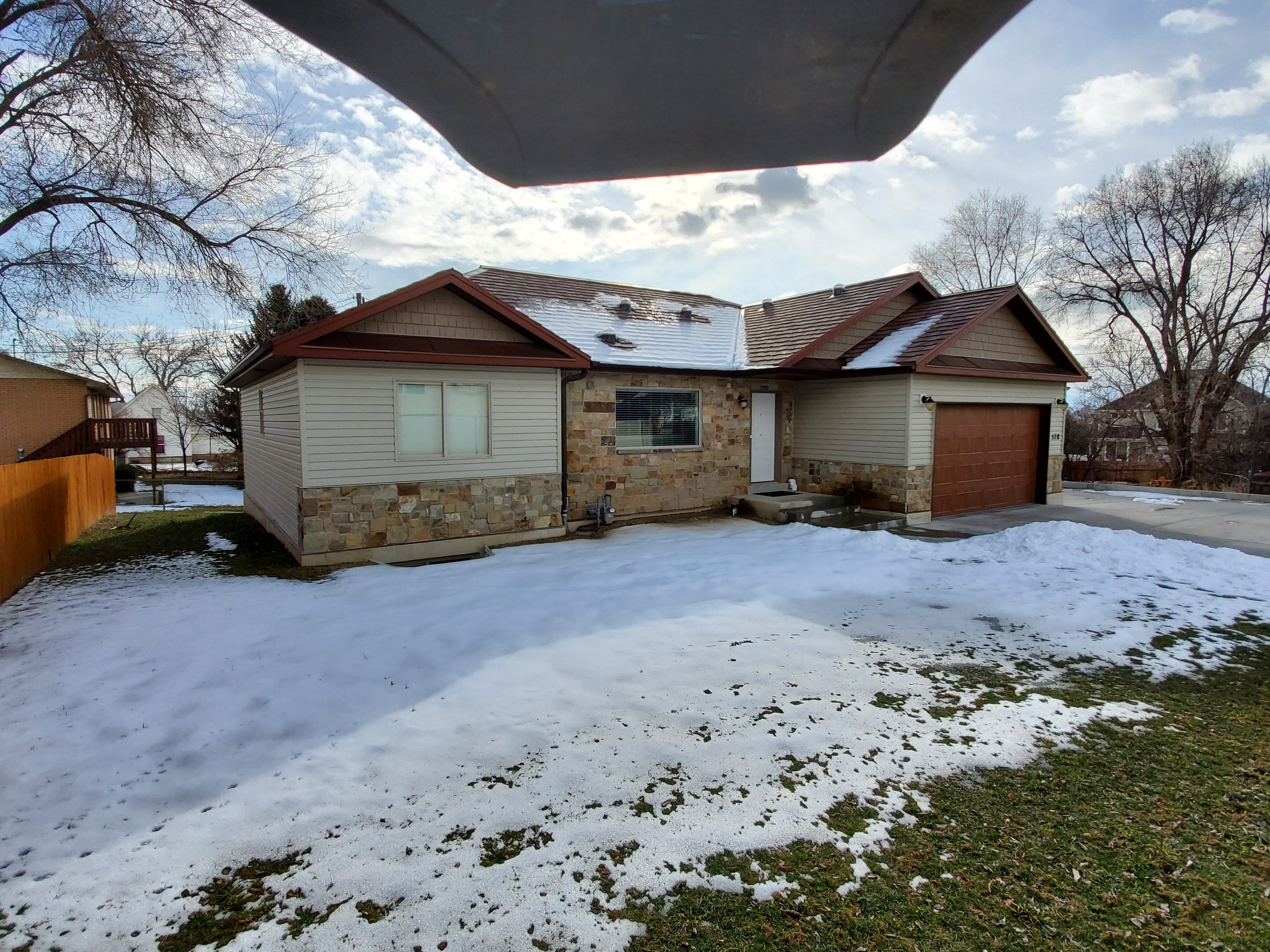 Total Photos: 5
|
| |
|
|
| Property Address: 578 E 100 SOUTH - PLEASANT GROVE |
|
| Mailing Address: 779 E CENTER ST PLEASANT GROVE, UT 84062-4557 |
|
| Acreage: 0.281232 |
|
| Last Document:
88122-2018
|
|
| Subdivision Map Filing |
|
| Taxing Description:
LOT 8, PLAT B, WALKER LANDING SUB AREA 0.281 AC.
*Taxing description NOT FOR LEGAL DOCUMENTS
|
|
- Owner Names
- Value History
- Tax History
- Location
- Photos
- Documents
- Aerial Image
| |
----- Real Estate Values ----- |
---Improvements--- |
---Greenbelt--- |
Total |
| Year |
Com |
Res |
Agr |
Tot |
Com |
Res |
Agr |
Tot |
Land |
Homesite |
Tot |
Market Value |
| 2024 |
$0 |
$293,900 |
$0 |
$293,900 |
$0 |
$323,900 |
$0 |
$323,900 |
$0 |
$0 |
$0 |
$617,800 |
| 2023 |
$0 |
$267,200 |
$0 |
$267,200 |
$0 |
$344,100 |
$0 |
$344,100 |
$0 |
$0 |
$0 |
$611,300 |
| 2022 |
$0 |
$281,000 |
$0 |
$281,000 |
$0 |
$318,600 |
$0 |
$318,600 |
$0 |
$0 |
$0 |
$599,600 |
| 2021 |
$0 |
$175,600 |
$0 |
$175,600 |
$0 |
$212,100 |
$0 |
$212,100 |
$0 |
$0 |
$0 |
$387,700 |
| 2020 |
$0 |
$162,600 |
$0 |
$162,600 |
$0 |
$203,900 |
$0 |
$203,900 |
$0 |
$0 |
$0 |
$366,500 |
| 2019 |
$0 |
$155,100 |
$0 |
$155,100 |
$0 |
$203,900 |
$0 |
$203,900 |
$0 |
$0 |
$0 |
$359,000 |
| 2018 |
$0 |
$139,900 |
$0 |
$139,900 |
$0 |
$177,300 |
$0 |
$177,300 |
$0 |
$0 |
$0 |
$317,200 |
| 2017 |
$0 |
$139,900 |
$0 |
$139,900 |
$0 |
$154,200 |
$0 |
$154,200 |
$0 |
$0 |
$0 |
$294,100 |
| 2016 |
$0 |
$113,500 |
$0 |
$113,500 |
$0 |
$207,200 |
$0 |
$207,200 |
$0 |
$0 |
$0 |
$320,700 |
| 2015 |
$0 |
$83,200 |
$0 |
$83,200 |
$0 |
$0 |
$0 |
$0 |
$0 |
$0 |
$0 |
$83,200 |
| 2014 |
$0 |
$80,900 |
$0 |
$80,900 |
$0 |
$0 |
$0 |
$0 |
$0 |
$0 |
$0 |
$80,900 |
| Year |
General Taxes |
Adjustments |
Net Taxes |
Fees |
Payments |
Tax Balance* |
Balance Due |
Tax District |
| 2025 |
$0.00 |
$0.00 |
$0.00 |
$0.00 |
|
$0.00
|
$0.00 |
070 - PLEASANT GROVE CITY |
| 2024 |
$0.00 |
$0.00 |
$0.00 |
$0.00 |
|
($63.88)
|
($63.88) |
070 - PLEASANT GROVE CITY |
| 2023 |
$2,751.92 |
($63.88) |
$2,688.04 |
$0.00 |
|
$0.00
|
$0.00 |
070 - PLEASANT GROVE CITY |
| 2022 |
$2,712.77 |
$0.00 |
$2,712.77 |
$0.00 |
|
$0.00
|
$0.00 |
070 - PLEASANT GROVE CITY |
| 2021 |
$2,094.61 |
$0.00 |
$2,094.61 |
$0.00 |
|
$0.00
|
$0.00 |
070 - PLEASANT GROVE CITY |
| 2020 |
$2,019.78 |
$0.00 |
$2,019.78 |
$0.00 |
|
$0.00
|
$0.00 |
070 - PLEASANT GROVE CITY |
| 2019 |
$1,913.09 |
$0.00 |
$1,913.09 |
$0.00 |
|
$0.00
|
$0.00 |
070 - PLEASANT GROVE CITY |
| 2018 |
$1,787.69 |
$0.00 |
$1,787.69 |
$0.00 |
|
$0.00
|
$0.00 |
070 - PLEASANT GROVE CITY |
| 2017 |
$1,712.34 |
$0.00 |
$1,712.34 |
$0.00 |
|
$0.00
|
$0.00 |
070 - PLEASANT GROVE CITY |
| 2016 |
$1,934.06 |
$0.00 |
$1,934.06 |
$0.00 |
|
$0.00
|
$0.00 |
070 - PLEASANT GROVE CITY |
| 2015 |
$963.37 |
$0.00 |
$963.37 |
$0.00 |
|
$0.00
|
$0.00 |
070 - PLEASANT GROVE CITY |
| 2014 |
$945.64 |
$0.00 |
$945.64 |
$0.00 |
|
$0.00
|
$0.00 |
070 - PLEASANT GROVE CITY |
* Note: Original tax amount (Does not include applicable interest and/or fees).
| Entry # |
Date |
Recorded |
Type |
Party1 (Grantor) |
Party2 (Grantee) |
| 38543-2021 |
02/02/2021 |
03/01/2021 |
WD |
WARBURTON, HEATHER |
578 PROPERTIES LLC |
| 146868-2020 |
09/11/2020 |
09/24/2020 |
N |
WARBURTON, HEATHER |
WHOM OF INTEREST |
| 116232-2019 |
11/07/2019 |
11/07/2019 |
WD |
KNIGHT WEST BUILDERS LLC |
WARBURTON, HEATHER |
| 88122-2018 |
07/16/2018 |
09/14/2018 |
WD |
KNIGHT WEST CONSTRUCTION INC |
KNIGHT WEST BUILDERS LLC |
| 67392-2014 |
08/04/2014 |
09/22/2014 |
REC |
BANK OF AMERICAN FORK TEE |
KNIGHT WEST CONSTRUCTION INC |
| 6509-2014 |
01/30/2014 |
01/30/2014 |
REC |
TITLE WEST TITLE COMPANY TEE |
KNIGHT WEST CONSTRUCTION INC |
| 100108-2013 |
08/20/2013 |
10/25/2013 |
S PLAT |
KNIGHT WEST CONSTRUCTION INC |
WALKER LANDING PLAT B |
Main Menu Comments or Concerns on Value/Appraisal - Assessor's Office
Documents/Owner/Parcel information - Recorder's Office
Address Change for Tax Notice
This page was created on 9/10/2024 1:57:45 AM |


