Property Information
mobile view
| Serial Number: 65:148:0219 |
Serial Life: 2006... |
|
|
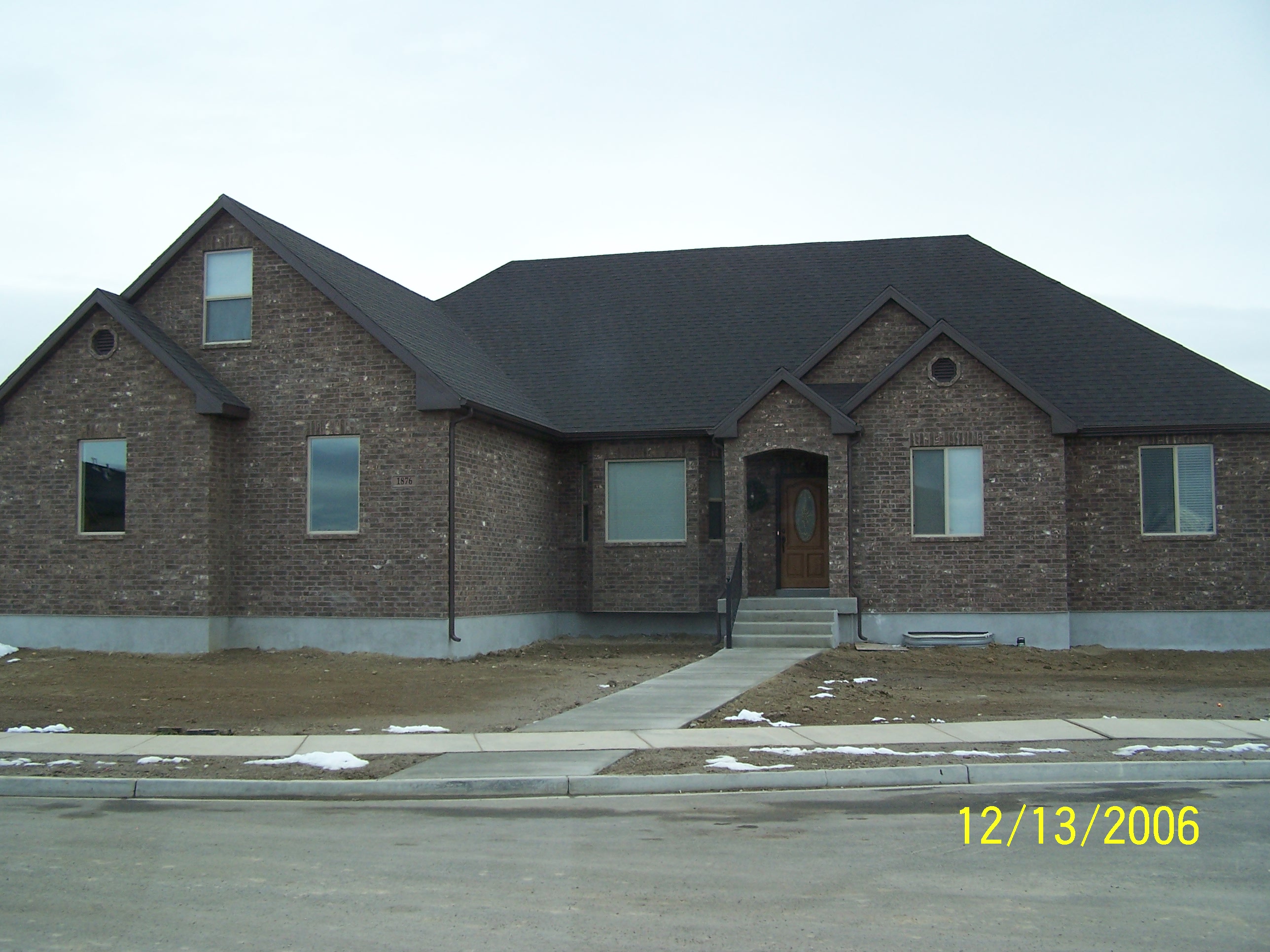 Total Photos: 1
|
| |
|
|
| Property Address: 1876 N 1700 EAST - LEHI |
|
| Mailing Address: 1876 N 1700 E LEHI, UT 84043-7432 |
|
| Acreage: 0.322 |
|
| Last Document:
93322-2005
|
|
| Subdivision Map Filing |
|
| Taxing Description:
LOT 219, PLAT J, CEDAR HOLLOW SUBDV. AREA 0.322 AC.
*Taxing description NOT FOR LEGAL DOCUMENTS
|
|
- Owner Names
- Value History
- Tax History
- Location
- Photos
- Documents
- Aerial Image
| |
----- Real Estate Values ----- |
---Improvements--- |
---Greenbelt--- |
Total |
| Year |
Com |
Res |
Agr |
Tot |
Com |
Res |
Agr |
Tot |
Land |
Homesite |
Tot |
Market Value |
| 2024 |
$0 |
$361,400 |
$0 |
$361,400 |
$0 |
$588,000 |
$0 |
$588,000 |
$0 |
$0 |
$0 |
$949,400 |
| 2023 |
$0 |
$350,900 |
$0 |
$350,900 |
$0 |
$606,200 |
$0 |
$606,200 |
$0 |
$0 |
$0 |
$957,100 |
| 2022 |
$0 |
$358,100 |
$0 |
$358,100 |
$0 |
$715,800 |
$0 |
$715,800 |
$0 |
$0 |
$0 |
$1,073,900 |
| 2021 |
$0 |
$223,800 |
$0 |
$223,800 |
$0 |
$583,400 |
$0 |
$583,400 |
$0 |
$0 |
$0 |
$807,200 |
| 2020 |
$0 |
$207,200 |
$0 |
$207,200 |
$0 |
$545,200 |
$0 |
$545,200 |
$0 |
$0 |
$0 |
$752,400 |
| 2019 |
$0 |
$207,200 |
$0 |
$207,200 |
$0 |
$509,400 |
$0 |
$509,400 |
$0 |
$0 |
$0 |
$716,600 |
| 2018 |
$0 |
$195,900 |
$0 |
$195,900 |
$0 |
$474,100 |
$0 |
$474,100 |
$0 |
$0 |
$0 |
$670,000 |
| 2017 |
$0 |
$114,500 |
$0 |
$114,500 |
$0 |
$424,300 |
$0 |
$424,300 |
$0 |
$0 |
$0 |
$538,800 |
| 2016 |
$0 |
$113,000 |
$0 |
$113,000 |
$0 |
$404,700 |
$0 |
$404,700 |
$0 |
$0 |
$0 |
$517,700 |
| 2015 |
$0 |
$113,000 |
$0 |
$113,000 |
$0 |
$404,700 |
$0 |
$404,700 |
$0 |
$0 |
$0 |
$517,700 |
| 2014 |
$0 |
$103,600 |
$0 |
$103,600 |
$0 |
$351,900 |
$0 |
$351,900 |
$0 |
$0 |
$0 |
$455,500 |
| 2013 |
$0 |
$78,300 |
$0 |
$78,300 |
$0 |
$306,000 |
$0 |
$306,000 |
$0 |
$0 |
$0 |
$384,300 |
| 2012 |
$0 |
$71,200 |
$0 |
$71,200 |
$0 |
$283,300 |
$0 |
$283,300 |
$0 |
$0 |
$0 |
$354,500 |
| 2011 |
$0 |
$67,600 |
$0 |
$67,600 |
$0 |
$290,500 |
$0 |
$290,500 |
$0 |
$0 |
$0 |
$358,100 |
| 2010 |
$0 |
$78,831 |
$0 |
$78,831 |
$0 |
$309,620 |
$0 |
$309,620 |
$0 |
$0 |
$0 |
$388,451 |
| 2009 |
$0 |
$218,600 |
$0 |
$218,600 |
$0 |
$205,800 |
$0 |
$205,800 |
$0 |
$0 |
$0 |
$424,400 |
| 2008 |
$0 |
$235,000 |
$0 |
$235,000 |
$0 |
$276,300 |
$0 |
$276,300 |
$0 |
$0 |
$0 |
$511,300 |
| 2007 |
$0 |
$250,000 |
$0 |
$250,000 |
$0 |
$293,900 |
$0 |
$293,900 |
$0 |
$0 |
$0 |
$543,900 |
| 2006 |
$0 |
$68,000 |
$0 |
$68,000 |
$0 |
$0 |
$0 |
$0 |
$0 |
$0 |
$0 |
$68,000 |
| Year |
General Taxes |
Adjustments |
Net Taxes |
Fees |
Payments |
Tax Balance* |
Balance Due |
Tax District |
| 2025 |
$0.00 |
$0.00 |
$0.00 |
$0.00 |
|
$0.00
|
$0.00 |
010 - LEHI CITY |
| 2024 |
$4,461.94 |
$0.00 |
$4,461.94 |
$0.00 |
|
$0.00
|
$0.00 |
010 - LEHI CITY |
| 2023 |
$4,142.81 |
$0.00 |
$4,142.81 |
$0.00 |
|
$0.00
|
$0.00 |
010 - LEHI CITY |
| 2022 |
$4,794.86 |
$0.00 |
$4,794.86 |
$0.00 |
|
$0.00
|
$0.00 |
010 - LEHI CITY |
| 2021 |
$4,334.38 |
$0.00 |
$4,334.38 |
$0.00 |
|
$0.00
|
$0.00 |
010 - LEHI CITY |
| 2020 |
$4,087.30 |
$0.00 |
$4,087.30 |
$0.00 |
|
$0.00
|
$0.00 |
010 - LEHI CITY |
| 2019 |
$3,744.63 |
$0.00 |
$3,744.63 |
$0.00 |
|
$0.00
|
$0.00 |
010 - LEHI CITY |
| 2018 |
$3,703.43 |
$0.00 |
$3,703.43 |
$0.00 |
|
$0.00
|
$0.00 |
010 - LEHI CITY |
| 2017 |
$3,081.05 |
$0.00 |
$3,081.05 |
$0.00 |
|
$0.00
|
$0.00 |
010 - LEHI CITY |
| 2016 |
$3,190.74 |
$0.00 |
$3,190.74 |
$0.00 |
|
$0.00
|
$0.00 |
010 - LEHI CITY |
| 2015 |
$3,361.30 |
$0.00 |
$3,361.30 |
$0.00 |
|
$0.00
|
$0.00 |
010 - LEHI CITY |
| 2014 |
$2,974.98 |
$0.00 |
$2,974.98 |
$0.00 |
|
$0.00
|
$0.00 |
010 - LEHI CITY |
| 2013 |
$2,721.54 |
$0.00 |
$2,721.54 |
$0.00 |
|
$0.00
|
$0.00 |
010 - LEHI CITY |
| 2012 |
$2,580.30 |
$0.00 |
$2,580.30 |
$0.00 |
|
$0.00
|
$0.00 |
010 - LEHI CITY |
| 2011 |
$2,589.96 |
$0.00 |
$2,589.96 |
$0.00 |
|
$0.00
|
$0.00 |
010 - LEHI CITY |
| 2010 |
$2,637.06 |
$0.00 |
$2,637.06 |
$0.00 |
|
$0.00
|
$0.00 |
010 - LEHI CITY |
| 2009 |
$2,559.68 |
$0.00 |
$2,559.68 |
$0.00 |
|
$0.00
|
$0.00 |
010 - LEHI CITY |
| 2008 |
$2,918.73 |
$0.00 |
$2,918.73 |
$0.00 |
|
$0.00
|
$0.00 |
010 - LEHI CITY |
| 2007 |
$3,022.26 |
$0.00 |
$3,022.26 |
$0.00 |
|
$0.00
|
$0.00 |
010 - LEHI CITY |
| 2006 |
$757.86 |
$0.00 |
$757.86 |
$0.00 |
|
$0.00
|
$0.00 |
010 - LEHI CITY |
* Note: Original tax amount (Does not include applicable interest and/or fees).
| Entry # |
Date |
Recorded |
Type |
Party1 (Grantor) |
Party2 (Grantee) |
| 89203-2022 |
08/10/2022 |
08/10/2022 |
REC |
MOUNTAIN AMERICA FEDERAL CREDIT UNION TEE |
CHRISTENSEN, KYLE B & RAMA JEAN |
| 74422-2022 |
06/17/2022 |
06/27/2022 |
D TR |
CHRISTENSEN, KYLE B & RAMA JEAN |
MOUNTAIN AMERICA FEDERAL CREDIT UNION |
| 145019-2021 |
08/12/2021 |
08/19/2021 |
REC |
MORAN, KEVIN P SUBTEE |
CHRISTENSEN, KYLE B & RAMA JEAN |
| 145018-2021 |
07/30/2021 |
08/19/2021 |
SUB TEE |
MORTGAGE ELECTRONIC REGISTRATION SYSTEMS INC |
MORAN, KEVIN P SUBTEE |
| 138410-2019 |
12/27/2019 |
12/27/2019 |
REC |
ALTABANK TEE |
CEDAR HOLLOW INC |
| 1538-2013 |
12/18/2012 |
01/07/2013 |
REC |
HALLIDAY, PAUL M JR SUCTEE |
CHRISTENSEN, KYLE B & RAMA JEAN |
| 1537-2013 |
11/13/2011 |
01/07/2013 |
SUB TEE |
MORTGAGE ELECTRONIC REGISTRATION SYSTEMS INC |
HALLIDAY, PAUL M JR SUBTEE |
| 65873-2012 |
07/26/2012 |
08/07/2012 |
D TR |
CHRISTENSEN, KYLE B & RAMA JEAN |
MOUNTAIN AMERICA FEDERAL CREDIT UNION |
| 50308-2012 |
06/12/2012 |
06/18/2012 |
D TR |
CHRISTENSEN, KYLE B & RAMA JEAN |
MOUNTAIN AMERICA FEDERAL CREDIT UNION |
| 50307-2012 |
06/12/2012 |
06/18/2012 |
WD |
CHRISTENSEN, KYLE B & RAMA JEAN |
CHRISTENSEN, KYLE B & RAMA JEAN |
| 47269-2012 |
06/01/2012 |
06/07/2012 |
REC |
U S BANK TRUST COMPANY TEE |
CHRISTENSEN, KYLE B & RAMA JEAN |
| 78526-2009 |
07/02/2009 |
07/17/2009 |
REC |
HALLIDAY, PAUL M SUCTEE |
CHRISTENSEN, KYLE B & RAMA JEAN |
| 78525-2009 |
06/09/2009 |
07/17/2009 |
SUB TEE |
MORTGAGE ELECTRONIC REGISTRATION SYSTEMS INC |
HALLIDAY, PAUL M SUCTEE |
| 66975-2009 |
05/22/2009 |
06/17/2009 |
D TR |
CHRISTENSEN, KYLE B & RAMA JEAN |
U S BANK NATIONAL ASSOCIATION |
| 28425-2009 |
03/11/2009 |
03/18/2009 |
D TR |
CHRISTENSEN, KYLE B & RAMA JEAN |
U S BANK |
| 114949-2008 |
10/20/2008 |
10/22/2008 |
CT |
STATE OF UTAH |
WHOM OF INTEREST |
| 107508-2008 |
09/30/2008 |
09/30/2008 |
RESOL |
BOARD OF COUNTY COMMISSIONERS UTAH COUNTY |
WHOM OF INTEREST |
| 7991-2007 |
01/16/2007 |
01/17/2007 |
REC |
FAR WEST BANK TEE |
CHRISTENSEN, KYLE B & RAMA JEAN |
| 169349-2006 |
12/13/2006 |
12/15/2006 |
D TR |
CHRISTENSEN, KYLE B & RAMA JEAN |
FAR WEST BANK |
| 92687-2006 |
07/05/2006 |
07/21/2006 |
REC |
CAPITAL COMMUNITY BANK TEE |
RLH DEVELOP LLC |
| 83354-2006 |
06/29/2006 |
06/30/2006 |
D TR |
CHRISTENSEN, KYLE B & RAMA JEAN |
FAR WEST BANK |
| 83353-2006 |
06/28/2006 |
06/30/2006 |
WD |
RLH DEVELOPMENT LLC |
CHRISTENSEN, KYLE B & RAMA JEAN |
| 40615-2006 |
04/04/2006 |
04/04/2006 |
D TR |
RLH DEVELOPMENT LLC |
CAPITAL COMMUNITY BANK |
| 15773-2006 |
02/08/2006 |
02/08/2006 |
R LN |
STAKER & PARSON COMPANIES INC |
CARSON, GARY L & JANE S (ET AL) |
| 9307-2006 |
01/18/2005 |
01/25/2006 |
N LN |
CARSON, GARY L & JANE S |
STAKER & PARSON COMPANIES INC |
| 1843-2006 |
01/04/2006 |
01/05/2006 |
WD |
CEDAR HOLLOW INC (ET AL) |
RLH DEVELOPMENT LLC |
| 1842-2006 |
01/04/2006 |
01/05/2006 |
DECLCOV |
CEDAR HOLLOW IN C (ET AL) |
WHOM OF INTEREST |
| 93323-2005 |
08/18/2005 |
08/23/2005 |
P REC |
BANK OF AMERICAN FORK TEE |
CEDAR HOLLOW INC |
| 93322-2005 |
08/22/2005 |
08/23/2005 |
WD |
CEDAR HOLLOW INC |
CARSON, GARY L & JANE S |
| 87927-2005 |
08/10/2005 |
08/10/2005 |
R FARM |
UTAH COUNTY TREASURER |
COOPER, RICHARD L (ET AL) |
| 87926-2005 |
08/10/2005 |
08/10/2005 |
R FARM |
UTAH COUNTY TREASURER |
COOPER, RICHARD L CB (ET AL) |
| 81973-2005 |
05/10/2005 |
07/28/2005 |
S PLAT |
CEDAR HOLLOW INC |
CEDAR HOLLOW PLAT J |
Main Menu Comments or Concerns on Value/Appraisal - Assessor's Office
Documents/Owner/Parcel information - Recorder's Office
Address Change for Tax Notice
This page was created on 4/23/2025 3:08:48 PM |