Property Information
mobile view
| Serial Number: 08:084:0030 |
Serial Life: 2006... |
|
|
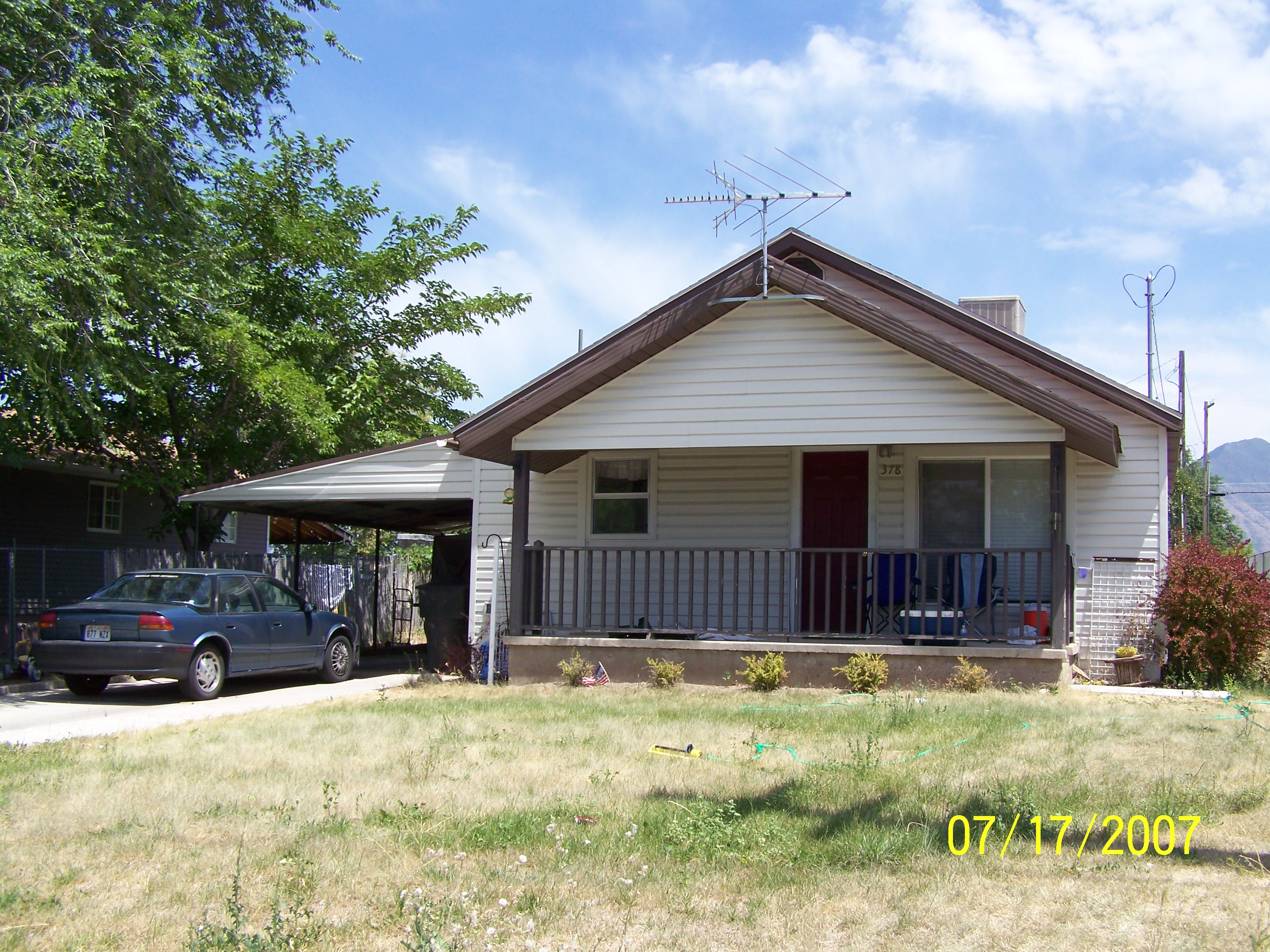 Total Photos: 3
|
| |
|
|
| Property Address: 378 N 500 EAST - PAYSON |
|
| Mailing Address: 378 N 500 E PAYSON, UT 84651-1936 |
|
| Acreage: 0.216449 |
|
| Last Document:
48145-2005
|
|
| Subdivision Map Filing |
|
| Taxing Description:
COM S 59 FT FR NW COR. BLK. 15, PLAT K, PAYSON CITY SURVEY; E 100 FT; S 54.5 FT; W 100 FT; N 54.5 FT TO BEG. AREA 0.125 AC. ALSO COM S 59 FT & E 100 FT FR NW COR. LOT 3, BLK. 15, PLAT K, PAYSON CITY SURVEY; E 73 FT; S 54.5 FT; W 73 FT; N 54.5 FT TO BEG. AREA 0.091 AC. TOTAL AREA .216 AC.
*Taxing description NOT FOR LEGAL DOCUMENTS
|
|
- Owner Names
- Value History
- Tax History
- Location
- Photos
- Documents
- Aerial Image
| 2022... |
|
MARADIAGA, BRUCE CHRISTIAN |
|
| 2022... |
|
MARADIAGA, CESAR AUGUSTO |
|
| 2020-2021 |
|
MARADIAGA, CESAR |
|
| 2020-2021 |
|
MARADIAGA, SAMANTHA |
|
| 2020NV |
|
MARADIAGA, CESAR |
|
| 2020NV |
|
MARADIAGA, CESAR |
|
| 2020NV |
|
MARADIAGA, SAMANTHA |
|
| 2019 |
|
MARADIAGA, CESAR |
|
| 2019NV |
|
PENNYMAC LOAN SERVICES LLC |
|
| 2015-2018 |
|
TALBOT, JESSE B |
|
| 2014 |
|
PETTINO, JORGE |
|
| 2013 |
|
LANGE, KIT |
|
| 2013 |
|
LANGE, TIFFANY |
|
| 2013NV |
|
SECRETARY OF HOUSING AND URBAN DEVELOPMENT THE |
|
| 2011-2012 |
|
BAC HOME LOANS SERVICING LP |
|
| 2007-2010 |
|
GULLICKSON, DAN |
|
| 2007-2010 |
|
GULLICKSON, JILL |
|
| 2006 |
|
KENT, JENNIFER M |
|
| 2006 |
|
KENT, TIMOTHY J |
|
| |
----- Real Estate Values ----- |
---Improvements--- |
---Greenbelt--- |
Total |
| Year |
Com |
Res |
Agr |
Tot |
Com |
Res |
Agr |
Tot |
Land |
Homesite |
Tot |
Market Value |
| 2024 |
$0 |
$107,800 |
$0 |
$107,800 |
$0 |
$254,400 |
$0 |
$254,400 |
$0 |
$0 |
$0 |
$362,200 |
| 2023 |
$0 |
$107,800 |
$0 |
$107,800 |
$0 |
$264,000 |
$0 |
$264,000 |
$0 |
$0 |
$0 |
$371,800 |
| 2022 |
$0 |
$114,900 |
$0 |
$114,900 |
$0 |
$262,100 |
$0 |
$262,100 |
$0 |
$0 |
$0 |
$377,000 |
| 2021 |
$0 |
$82,100 |
$0 |
$82,100 |
$0 |
$201,600 |
$0 |
$201,600 |
$0 |
$0 |
$0 |
$283,700 |
| 2020 |
$0 |
$71,400 |
$0 |
$71,400 |
$0 |
$187,000 |
$0 |
$187,000 |
$0 |
$0 |
$0 |
$258,400 |
| 2019 |
$0 |
$64,300 |
$0 |
$64,300 |
$0 |
$172,800 |
$0 |
$172,800 |
$0 |
$0 |
$0 |
$237,100 |
| 2018 |
$0 |
$54,300 |
$0 |
$54,300 |
$0 |
$141,900 |
$0 |
$141,900 |
$0 |
$0 |
$0 |
$196,200 |
| 2017 |
$0 |
$51,400 |
$0 |
$51,400 |
$0 |
$123,400 |
$0 |
$123,400 |
$0 |
$0 |
$0 |
$174,800 |
| 2016 |
$0 |
$46,400 |
$0 |
$46,400 |
$0 |
$109,100 |
$0 |
$109,100 |
$0 |
$0 |
$0 |
$155,500 |
| 2015 |
$0 |
$42,800 |
$0 |
$42,800 |
$0 |
$99,800 |
$0 |
$99,800 |
$0 |
$0 |
$0 |
$142,600 |
| 2014 |
$0 |
$39,300 |
$0 |
$39,300 |
$0 |
$86,800 |
$0 |
$86,800 |
$0 |
$0 |
$0 |
$126,100 |
| 2013 |
$0 |
$33,800 |
$0 |
$33,800 |
$0 |
$79,600 |
$0 |
$79,600 |
$0 |
$0 |
$0 |
$113,400 |
| 2012 |
$0 |
$35,100 |
$0 |
$35,100 |
$0 |
$79,700 |
$0 |
$79,700 |
$0 |
$0 |
$0 |
$114,800 |
| 2011 |
$0 |
$33,100 |
$0 |
$33,100 |
$0 |
$88,400 |
$0 |
$88,400 |
$0 |
$0 |
$0 |
$121,500 |
| 2010 |
$0 |
$36,433 |
$0 |
$36,433 |
$0 |
$92,677 |
$0 |
$92,677 |
$0 |
$0 |
$0 |
$129,110 |
| 2009 |
$0 |
$51,400 |
$0 |
$51,400 |
$0 |
$81,000 |
$0 |
$81,000 |
$0 |
$0 |
$0 |
$132,400 |
| 2008 |
$0 |
$51,400 |
$0 |
$51,400 |
$0 |
$81,500 |
$0 |
$81,500 |
$0 |
$0 |
$0 |
$132,900 |
| 2007 |
$0 |
$53,000 |
$0 |
$53,000 |
$0 |
$48,800 |
$0 |
$48,800 |
$0 |
$0 |
$0 |
$101,800 |
| 2006 |
$0 |
$35,700 |
$0 |
$35,700 |
$0 |
$35,400 |
$0 |
$35,400 |
$0 |
$0 |
$0 |
$71,100 |
| Year |
General Taxes |
Adjustments |
Net Taxes |
Fees |
Payments |
Tax Balance* |
Balance Due |
Tax District |
| 2025 |
$0.00 |
$0.00 |
$0.00 |
$0.00 |
|
$0.00
|
$0.00 |
170 - PAYSON CITY |
| 2024 |
$1,957.44 |
$0.00 |
$1,957.44 |
$0.00 |
|
$0.00
|
$0.00 |
170 - PAYSON CITY |
| 2023 |
$2,003.80 |
$0.00 |
$2,003.80 |
$0.00 |
|
$0.00
|
$0.00 |
170 - PAYSON CITY |
| 2022 |
$2,065.83 |
$0.00 |
$2,065.83 |
$0.00 |
|
$0.00
|
$0.00 |
170 - PAYSON CITY |
| 2021 |
$1,762.26 |
$0.00 |
$1,762.26 |
$0.00 |
|
$0.00
|
$0.00 |
170 - PAYSON CITY |
| 2020 |
$1,640.63 |
$0.00 |
$1,640.63 |
$0.00 |
|
$0.00
|
$0.00 |
170 - PAYSON CITY |
| 2019 |
$1,468.36 |
$0.00 |
$1,468.36 |
$0.00 |
|
$0.00
|
$0.00 |
170 - PAYSON CITY |
| 2018 |
$1,260.71 |
$0.00 |
$1,260.71 |
$0.00 |
|
$0.00
|
$0.00 |
170 - PAYSON CITY |
| 2017 |
$1,148.58 |
$0.00 |
$1,148.58 |
$0.00 |
|
$0.00
|
$0.00 |
170 - PAYSON CITY |
| 2016 |
$1,028.52 |
$0.00 |
$1,028.52 |
$0.00 |
|
$0.00
|
$0.00 |
170 - PAYSON CITY |
| 2015 |
$949.71 |
$0.00 |
$949.71 |
$0.00 |
|
$0.00
|
$0.00 |
170 - PAYSON CITY |
| 2014 |
$833.79 |
$0.00 |
$833.79 |
$0.00 |
|
$0.00
|
$0.00 |
170 - PAYSON CITY |
| 2013 |
$784.86 |
$0.00 |
$784.86 |
$0.00 |
|
$0.00
|
$0.00 |
170 - PAYSON CITY |
| 2012 |
$806.55 |
$0.00 |
$806.55 |
$0.00 |
|
$0.00
|
$0.00 |
170 - PAYSON CITY |
| 2011 |
$833.37 |
$0.00 |
$833.37 |
$0.00 |
|
$0.00
|
$0.00 |
170 - PAYSON CITY |
| 2010 |
$863.48 |
$0.00 |
$863.48 |
$0.00 |
|
$0.00
|
$0.00 |
170 - PAYSON CITY |
| 2009 |
$838.67 |
$0.00 |
$838.67 |
$0.00 |
|
$0.00
|
$0.00 |
170 - PAYSON CITY |
| 2008 |
$783.07 |
$0.00 |
$783.07 |
$0.00 |
|
$0.00
|
$0.00 |
170 - PAYSON CITY |
| 2007 |
$594.95 |
$0.00 |
$594.95 |
$0.00 |
|
$0.00
|
$0.00 |
170 - PAYSON CITY |
| 2006 |
$461.71 |
$0.00 |
$461.71 |
$0.00 |
|
$0.00
|
$0.00 |
170 - PAYSON CITY |
* Note: Original tax amount (Does not include applicable interest and/or fees).
| Entry # |
Date |
Recorded |
Type |
Party1 (Grantor) |
Party2 (Grantee) |
| 42084-2024 |
06/17/2024 |
06/26/2024 |
AS |
MORTGAGE ELECTRONIC REGISTRATION SYSTEMS INC |
JPMORGAN CHASE BANK |
| 177414-2021 |
09/23/2021 |
10/18/2021 |
RSUBTEE |
MORTGAGE ELECTRONIC REGISTRATION SYSTEMS INC (ET AL) |
MARADIAGA, CESAR |
| 156054-2021 |
09/02/2021 |
09/08/2021 |
D TR |
MARADIAGA, CESAR AUGUSTO & BRUCE CHRISTIAN |
CARDINAL FINANCIAL COMPANY LIMITED PARTNERSHIP |
| 156053-2021 |
09/02/2021 |
09/08/2021 |
WD |
MARADIAGA, CESAR & SAMANTHA |
MARADIAGA, CESAR AUGUSTO & BRUCE CHRISTIAN |
| 56756-2019 |
06/14/2019 |
06/21/2019 |
REC |
MORAN, KEVIN P TEE |
MARADIAGA, CESAR |
| 56755-2019 |
06/14/2019 |
06/21/2019 |
SUB TEE |
MORTGAGE ELECTRONIC REGISTRATION SYSTEMS INC |
MORAN, KEVIN P SUCTEE |
| 41114-2019 |
05/06/2019 |
05/10/2019 |
SP WD |
MARADIAGA, CESAR |
MARADIAGA, CESAR & SAMANTHA |
| 41113-2019 |
05/06/2019 |
05/10/2019 |
D TR |
MARADIAGA, CESAR |
UNITED WHOLESALE MORTGAGE LLC |
| 41112-2019 |
05/07/2019 |
05/10/2019 |
SP WD |
MARADIAGA, CESAR & SAMANTHA |
MARADIAGA, CESAR |
| 15788-2019 |
03/29/2018 |
02/26/2019 |
WD |
MARADIAGA, CESAR |
MARADIAGA, CESAR & SAMANTHA |
| 29884-2018 |
03/29/2018 |
03/30/2018 |
D TR |
MARADIAGA, CESAR |
CASTLE & COOKE MORTGAGE LLC |
| 29883-2018 |
03/29/2018 |
03/30/2018 |
SP WD |
PENNYMAC LOAN SERVICES LLC |
MARADIAGA, CESAR |
| 8533-2018 |
01/19/2018 |
01/26/2018 |
CAN ND |
ORANGE TITLE INSURANCE AGENCY INC |
TALBOT, JESSE B |
| 1271-2018 |
01/02/2018 |
01/04/2018 |
REC |
ORANGE TITLE INSURANCE AGENCY |
TALBOT, JESSE B |
| 1232-2018 |
09/22/2017 |
01/04/2018 |
D FORC |
TALBOT, JESSE B |
PENNYMAC LOAN SERVICES LLC |
| 118464-2016 |
11/22/2016 |
11/23/2016 |
ND |
ORANGE TITLE INSURANCE AGENCY INC TEE |
TALBOT, JESSE B |
| 118463-2016 |
11/02/2016 |
11/23/2016 |
SUB TEE |
PENNYMAC LOAN SERVICES LLC |
ORANGE TITLE INSURANCE AGENCY INC SUCTEE |
| 105683-2016 |
10/17/2016 |
10/21/2016 |
AS |
MORTGAGE ELECTRONIC REGISTRATION SYSTEMS INC |
PENNYMAC LOAN SERVICES LLC |
| 3187-2015 |
12/04/2014 |
01/14/2015 |
QCD |
UNITED STATES OF AMERICA |
SOUTH UTAH VALLEY ELECTRIC SERVICE DISTRICT |
| 89534-2014 |
12/11/2014 |
12/12/2014 |
REC |
WELLS FARGO FINANCIAL NATIONAL BANK TEE |
PETTINO, JORGE |
| 89533-2014 |
12/11/2014 |
12/12/2014 |
SUB TEE |
MORTGAGE ELECTRONIC REGISTRATION SYSTEMS INC |
WELLS FARGO FINANCIAL NATIONAL BANK SUCTEE |
| 85611-2014 |
11/25/2014 |
11/26/2014 |
D TR |
TALBOT, JESSE B |
VERITAS FUNDING LLC |
| 85600-2014 |
11/25/2014 |
11/26/2014 |
WD |
PETTINO, JORGE |
TALBOT, JESSE B |
| 10363-2013 |
01/31/2013 |
02/01/2013 |
D TR |
PETTINO, JORGE |
RANLIFE INC |
| 10346-2013 |
01/31/2013 |
02/01/2013 |
WD |
LANGE, KIT & TIFFANY |
PETTINO, JORGE |
| 80776-2012 |
09/17/2012 |
09/20/2012 |
SP WD |
SECRETARY OF HOUSING AND URBAN DEVELOPMENT THE BY (ET AL) |
LANGE, KIT & TIFFANY |
| 30700-2012 |
02/22/2010 |
04/13/2012 |
SP WD |
BAC HOME LOANS SERVICING LP FKA (ET AL) |
SECRETARY OF HOUSING AND URBAN DEVELOPMENT THE |
| 15323-2010 |
02/22/2010 |
02/24/2010 |
TEE D |
RECONTRUST COMPANY SUCTEE (ET AL) |
BAC HOME LOANS SERVICING LP |
| 95797-2009 |
08/31/2009 |
09/01/2009 |
ND |
RECONTRUST COMPANY |
GULLICKSON, DAN & JILL |
| 95796-2009 |
08/31/2009 |
09/01/2009 |
SUB TEE |
BAC HOME LOANS SERVICING LP |
RECONTRUST COMPANY SUCTEE |
| 95795-2009 |
08/31/2009 |
09/01/2009 |
AS |
MORTGAGE ELECTRONIC REGISTRATION SYSTEMS INC |
BAC HOME LOANS SERVICING LP |
| 4055-2009 |
01/08/2009 |
01/15/2009 |
RSUBTEE |
MORTGAGE ELECTRONIC REGISTRATION SYSTEMS INC (ET AL) |
GULLICKSON, DAN & JILL |
| 133982-2008 |
12/18/2008 |
12/26/2008 |
D TR |
GULLICKSON, DAN & JILL |
COUNTRYWIDE BANK |
| 114949-2008 |
10/20/2008 |
10/22/2008 |
CT |
STATE OF UTAH |
WHOM OF INTEREST |
| 107508-2008 |
09/30/2008 |
09/30/2008 |
RESOL |
BOARD OF COUNTY COMMISSIONERS UTAH COUNTY |
WHOM OF INTEREST |
| 151006-2006 |
08/07/2006 |
11/09/2006 |
REC |
INWEST TITLE SERVICES INC TEE |
KENT, TIMOTHY J & JENNIFER M |
| 117272-2006 |
09/02/2006 |
09/07/2006 |
REC |
RIVERS, ROD TEE |
KENT, TIMOTHY J & JENNIFER M |
| 117271-2006 |
08/30/2006 |
09/07/2006 |
SUB TEE |
WASHINGTON MUTUAL BANK |
RIVERS, ROD SUCTEE |
| 96983-2006 |
07/27/2006 |
07/31/2006 |
D TR |
GULLICKSON, DAN & JILL |
NEW FREEDOM MORTGAGE CORPORATION |
| 96961-2006 |
07/27/2006 |
07/31/2006 |
WD |
KENT, TIMOTHY J & JENNIFER M |
GULLICKSON, DAN & JILL |
| 48145-2005 |
05/04/2005 |
05/04/2005 |
QCD |
KENT, TIMOTHY J & JENNIFER M |
KENT, TIMOTHY J & JENNIFER M |
Main Menu Comments or Concerns on Value/Appraisal - Assessor's Office
Documents/Owner/Parcel information - Recorder's Office
Address Change for Tax Notice
This page was created on 4/6/2025 12:25:38 PM |

