Property Information
mobile view
| Serial Number: 51:499:0003 |
Serial Life: 2008... |
|
|
Total Photos: 1
|
| |
|
|
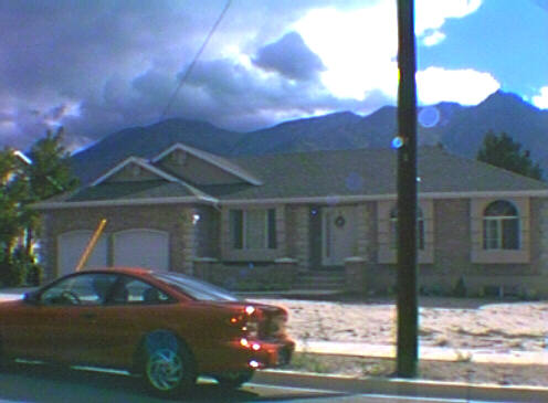
| Property Address: 694 E 1600 SOUTH - OREM |
|
| Mailing Address: 694 E 1600 S OREM, UT 84097 |
|
| Acreage: 0.226 |
|
| Last Document:
29021-2015
|
|
| Subdivision Map Filing |
|
| Taxing Description:
LOT 3, PLAT D, ROSE LANE SUBDV. AREA 0.226 AC.
*Taxing description NOT FOR LEGAL DOCUMENTS
|
|
- Owner Names
- Value History
- Tax History
- Location
- Photos
- Documents
- Aerial Image
| |
----- Real Estate Values ----- |
---Improvements--- |
---Greenbelt--- |
Total |
| Year |
Com |
Res |
Agr |
Tot |
Com |
Res |
Agr |
Tot |
Land |
Homesite |
Tot |
Market Value |
| 2024 |
$0 |
$191,100 |
$0 |
$191,100 |
$0 |
$372,400 |
$0 |
$372,400 |
$0 |
$0 |
$0 |
$563,500 |
| 2023 |
$0 |
$191,100 |
$0 |
$191,100 |
$0 |
$354,600 |
$0 |
$354,600 |
$0 |
$0 |
$0 |
$545,700 |
| 2022 |
$0 |
$203,800 |
$0 |
$203,800 |
$0 |
$302,100 |
$0 |
$302,100 |
$0 |
$0 |
$0 |
$505,900 |
| 2021 |
$0 |
$119,900 |
$0 |
$119,900 |
$0 |
$279,700 |
$0 |
$279,700 |
$0 |
$0 |
$0 |
$399,600 |
| 2020 |
$0 |
$95,900 |
$0 |
$95,900 |
$0 |
$271,600 |
$0 |
$271,600 |
$0 |
$0 |
$0 |
$367,500 |
| 2019 |
$0 |
$95,900 |
$0 |
$95,900 |
$0 |
$258,100 |
$0 |
$258,100 |
$0 |
$0 |
$0 |
$354,000 |
| 2018 |
$0 |
$89,000 |
$0 |
$89,000 |
$0 |
$258,100 |
$0 |
$258,100 |
$0 |
$0 |
$0 |
$347,100 |
| 2017 |
$0 |
$78,800 |
$0 |
$78,800 |
$0 |
$224,400 |
$0 |
$224,400 |
$0 |
$0 |
$0 |
$303,200 |
| 2016 |
$0 |
$58,200 |
$0 |
$58,200 |
$0 |
$243,500 |
$0 |
$243,500 |
$0 |
$0 |
$0 |
$301,700 |
| 2015 |
$0 |
$57,500 |
$0 |
$57,500 |
$0 |
$223,900 |
$0 |
$223,900 |
$0 |
$0 |
$0 |
$281,400 |
| 2014 |
$0 |
$54,100 |
$0 |
$54,100 |
$0 |
$0 |
$0 |
$0 |
$0 |
$0 |
$0 |
$54,100 |
| 2013 |
$0 |
$44,800 |
$0 |
$44,800 |
$0 |
$0 |
$0 |
$0 |
$0 |
$0 |
$0 |
$44,800 |
| 2012 |
$0 |
$43,000 |
$0 |
$43,000 |
$0 |
$0 |
$0 |
$0 |
$0 |
$0 |
$0 |
$43,000 |
| 2011 |
$0 |
$45,900 |
$0 |
$45,900 |
$0 |
$0 |
$0 |
$0 |
$0 |
$0 |
$0 |
$45,900 |
| 2010 |
$0 |
$61,339 |
$0 |
$61,339 |
$0 |
$0 |
$0 |
$0 |
$0 |
$0 |
$0 |
$61,339 |
| 2009 |
$0 |
$73,200 |
$0 |
$73,200 |
$0 |
$0 |
$0 |
$0 |
$0 |
$0 |
$0 |
$73,200 |
| 2008 |
$0 |
$76,200 |
$0 |
$76,200 |
$0 |
$0 |
$0 |
$0 |
$0 |
$0 |
$0 |
$76,200 |
| Year |
General Taxes |
Adjustments |
Net Taxes |
Fees |
Payments |
Tax Balance* |
Balance Due |
Tax District |
| 2025 |
$0.00 |
$0.00 |
$0.00 |
$0.00 |
|
$0.00
|
$0.00 |
090 - OREM CITY |
| 2024 |
$0.00 |
$0.00 |
$0.00 |
$0.00 |
|
$0.00
|
$0.00 |
090 - OREM CITY |
| 2023 |
$2,283.73 |
$0.00 |
$2,283.73 |
$0.00 |
|
$0.00
|
$0.00 |
090 - OREM CITY |
| 2022 |
$2,185.34 |
$0.00 |
$2,185.34 |
$0.00 |
|
$0.00
|
$0.00 |
090 - OREM CITY |
| 2021 |
$2,072.09 |
$0.00 |
$2,072.09 |
$0.00 |
|
$0.00
|
$0.00 |
090 - OREM CITY |
| 2020 |
$1,938.99 |
$0.00 |
$1,938.99 |
$0.00 |
|
$0.00
|
$0.00 |
090 - OREM CITY |
| 2019 |
$1,796.11 |
$0.00 |
$1,796.11 |
$0.00 |
|
$0.00
|
$0.00 |
090 - OREM CITY |
| 2018 |
$1,843.19 |
$0.00 |
$1,843.19 |
$0.00 |
|
$0.00
|
$0.00 |
090 - OREM CITY |
| 2017 |
$1,653.09 |
$0.00 |
$1,653.09 |
$0.00 |
|
$0.00
|
$0.00 |
090 - OREM CITY |
| 2016 |
$1,783.80 |
$0.00 |
$1,783.80 |
$0.00 |
|
$0.00
|
$0.00 |
090 - OREM CITY |
| 2015 |
$1,759.27 |
$0.00 |
$1,759.27 |
$0.00 |
|
$0.00
|
$0.00 |
090 - OREM CITY |
| 2014 |
$617.77 |
$0.00 |
$617.77 |
$0.00 |
|
$0.00
|
$0.00 |
090 - OREM CITY |
| 2013 |
$551.67 |
$0.00 |
$551.67 |
$0.00 |
|
$0.00
|
$0.00 |
090 - OREM CITY |
| 2012 |
$540.42 |
$0.00 |
$540.42 |
$0.00 |
|
$0.00
|
$0.00 |
090 - OREM CITY |
| 2011 |
$574.12 |
$0.00 |
$574.12 |
$0.00 |
|
$0.00
|
$0.00 |
090 - OREM CITY |
| 2010 |
$718.28 |
$0.00 |
$718.28 |
$0.00 |
|
$0.00
|
$0.00 |
090 - OREM CITY |
| 2009 |
$794.59 |
$0.00 |
$794.59 |
$0.00 |
|
$0.00
|
$0.00 |
090 - OREM CITY |
| 2008 |
$766.50 |
$0.00 |
$766.50 |
$0.00 |
|
$0.00
|
$0.00 |
090 - OREM CITY |
* Note: Original tax amount (Does not include applicable interest and/or fees).
| Entry # |
Date |
Recorded |
Type |
Party1 (Grantor) |
Party2 (Grantee) |
| 6596-2023 |
01/28/2023 |
02/02/2023 |
RSUBTEE |
MORTGAGE ELECTRONIC REGISTRATION SYSTEMS INC (ET AL) |
WASHBURN, DANIEL |
| 29021-2015 |
04/06/2015 |
04/08/2015 |
WD |
WASHBURN, DANIEL |
WASHBURN, DANIEL & HEIDI (ET AL) |
| 29020-2015 |
04/07/2015 |
04/08/2015 |
D TR |
WASHBURN, DANIEL |
LASER LENDING LLC |
| 29001-2015 |
04/08/2015 |
04/08/2015 |
WD |
ANDREWS, CHASE |
WASHBURN, DANIEL |
| 22351-2015 |
03/12/2015 |
03/19/2015 |
AF |
CITY OF OREM |
WHOM OF INTEREST |
| 22350-2015 |
12/04/2014 |
03/19/2015 |
N |
ANDREWS, CHASE |
WHOM OF INTEREST |
| 21040-2014 |
03/28/2014 |
03/31/2014 |
WD |
MURRAY, SCOTT & KAREN G TEE (ET AL) |
ANDREWS, CHASE |
| 10270-2011 |
02/01/2011 |
02/02/2011 |
WD |
MURRAY, SCOTT |
MURRAY, SCOTT & KAREN G TEE |
| 104525-2010 |
12/01/2010 |
12/01/2010 |
WD |
MURRAY, SCOTT |
MURRAY, SCOTT & KAREN G TEE |
| 125674-2007 |
11/15/2006 |
08/27/2007 |
S PLAT |
MURRAY, SCOTT |
ROSE LANE PLAT D |
Main Menu Comments or Concerns on Value/Appraisal - Assessor's Office
Documents/Owner/Parcel information - Recorder's Office
Address Change for Tax Notice
This page was created on 7/16/2024 7:45:13 AM |